
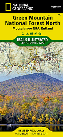
Green Mountains Natl Forest, Moosalamoo NRA-Rutland, Map 747 by National Geographic Maps
• Waterproof • Tear-Resistant • Topographic Map
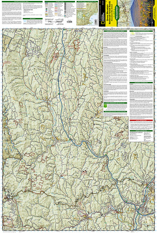
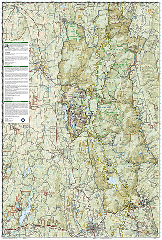
National Geographics Green Mountain National Forest North Trails Illustrated topographic map is comprehensive for outdoor enthusiasts of all types. Designed to be easy-to-read, yet highly detailed - this map includes a comprehensive road and trail network distinguishing between major, secondary and 4x4 roads, hiking, horse, biking, multi-use and non-motorized winter trails. All forest roads are labeled with their official road number and trails are clearly identified with their given name. Land management boundaries are color-coded showing National Forest, Ranger District, Wilderness Areas, Conservation Areas and more, plus the locations of private land within the Green Mountain National Forest. The renowned Appalachian Trail, Catamount Trail, and Long Trails are highlighted on the map.
An extensive collection of important and unique locations are pinpointed on the map including: visitor centers, campgrounds and backcountry shelters, picnic facilities, parking areas, RV dump sites, interpretive trails, boat launches, swimming holes, fishing areas, downhill and cross-country ski areas, waterfalls, viewpoints, museums, concessions, and Vermonts scenic covered bridges.
Every National Geographic Trails Illustrated map is an essential tool for safely navigating the backcountry with GPS or compass as they are clearly marked with both Latitude/Longitude and UTM coordinate grids, compass rose with magnetic declination, scale bar, and full legend.
Some of the places shown on the west side of the Green Mountain N.F. map are: Moosalamoo National Recreation Area, Joseph Battell Wilderness, Bristol Cliffs Wilderness, Breadloaf Wilderness, Rutland, Killington, Pico Ski Area, Sugarbush Ski Area, Lake Bomoseen, and more.
The east side of the map features: Hanover (NH), White River Junction, Woodstock, Quechee, Killington, White River, Connecticut River, Suicide Six Ski Area, Les Newell Wildlife Management Area, Granville Reservation, Roxbury State Forest, and more.
This Trails Illustrated map is printed in the U.S.A. on a durable synthetic paper, making it waterproof, tear-resistant, and capable for withstanding any condition mother nature can dish out. The map is two-sided, and can be folded to a packable size of (4.25 x 9.25), unfolded size is (26 x 38).
Green Mountains National Forest North adjoins the Green Mountains National Forest South map providing seamless coverage of Vermonts Green Mountain National Forest.
- Product Number: 2053341M
- Product Code: TI_GRNMTN_N
- Publisher Product ID: TI00000747
- ISBN: 9781566955119
- Year of Publication: 2010
- Folded Size: 9.45 x 4.33 inches
- Unfolded Size: 37.01 x 24.8 inches
- Map type: Folded Map
- Geographical region: Vermont


