Beaumont Topo Map Texas
To zoom in, hover over the map of Beaumont
USGS Topo Map 30094a1 - 1:100,000 scale
| Topo Map Name: | Beaumont |
| USGS Topo Quad ID: | 30094a1 |
| Print Size: | ca. 39" wide x 24" high |
| Southeast Coordinates: | 30° N latitude / 94° W longitude |
| Map Center Coordinates: | 30.25° N latitude / 94.5° W longitude |
| U.S. State: | TX |
| Filename: | 30094a1.jpg |
| Download Map JPG Image: | Beaumont topo map 1:100,000 scale |
| Map Type: | Topographic |
| Topo Series: | 30´x60´ |
| Map Scale: | 1:100,000 |
| Source of Map Images: | United States Geological Survey (USGS) |
| Alternate Map Versions: |
Beaumont TX 1986, updated 1986 Download PDF Buy paper map |
1:100,000 Topos surrounding Beaumont
Huntsville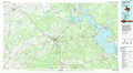 |
Livingston |
De Ridder |
Conroe |
Beaumont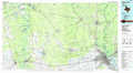 |
Lake Charles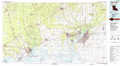 |
Houston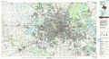 |
Anahuac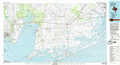 |
Port Arthur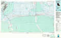 |
> Back to 30094a1 at 1:250,000 scale
> Back to U.S. Topo Maps home
1:24,000 Topo Quads covered by the spatial extent of this 100k map (Beaumont)
|
Rayburn 
|
Romayor 
|
Votaw 
|
Bragg 
|
Village Mills 
|
Kountze North 
|
Deserter Baygall 
|
Franklin Lake 
|
|
Tarkington Prairie 
|
Davis Hill 
|
Arizona Creek 
|
Saratoga 
|
Kountze Sw 
|
Kountze South 
|
Silsbee 
|
Evadale 
|
|
Simmons Bottom 
|
Capers Ridge 
|
Hardin 
|
Thorson Gully 
|
Sour Lake 
|
Bevil Oaks 
|
Voth 
|
Pine Forest 
|
|
Dayton 
|
Liberty 
|
Daisetta 
|
Devers 
|
Nome 
|
China 
|
Beaumont West 
|
Beaumont East 
|
