Chiricahua Peak Topo Map Arizona
To zoom in, hover over the map of Chiricahua Peak
USGS Topo Map 31109e1 - 1:100,000 scale
| Topo Map Name: | Chiricahua Peak |
| USGS Topo Quad ID: | 31109e1 |
| Print Size: | ca. 39" wide x 24" high |
| Southeast Coordinates: | 31.5° N latitude / 109° W longitude |
| Map Center Coordinates: | 31.75° N latitude / 109.5° W longitude |
| U.S. States: | AZ, NM |
| Filename: | 31109e1.jpg |
| Download Map JPG Image: | Chiricahua Peak topo map 1:100,000 scale |
| Map Type: | Topographic |
| Topo Series: | 30´x60´ |
| Map Scale: | 1:100,000 |
| Source of Map Images: | United States Geological Survey (USGS) |
| Alternate Map Versions: |
Chiricahua Peak AZ 1994, updated 1994 Download PDF Buy paper map Chiricahua Peak AZ 1994, updated 1994 Download PDF Buy paper map |
1:100,000 Topos surrounding Chiricahua Peak
Tucson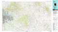 |
Willcox |
Lordsburg |
Fort Huachuca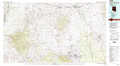 |
Chiricahua Peak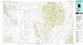 |
Animas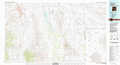 |
Nogales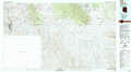 |
Douglas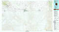 |
Alamo Hueco Mountains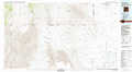 |
> Back to 31108a1 at 1:250,000 scale
> Back to U.S. Topo Maps home
1:24,000 Topo Quads covered by the spatial extent of this 100k map (Chiricahua Peak)
|
Cochise Stronghold 
|
Pearce 
|
Sulphur Hills 
|
Pat Hills South 
|
Fife Peak 
|
Rustler Park 
|
Portal 
|
Portal Ne 
|
|
Black Diamond Peak 
|
Turquoise Mountain 
|
Squaretop Hills West 
|
Squaretop Hills East 
|
Stanford Canyon 
|
Chiricahua Peak 
|
Portal Peak 
|
Rodeo 
|
|
Hay Mountain 
|
Outlaw Mountain 
|
Elfrida 
|
Swisshelm Mountain 
|
Bruno Peak 
|
Swede Peak 
|
Apache 
|
Skull Canyon 
|
|
Potter Mountain 
|
Gleeson Se 
|
Mcneal 
|
Leslie Canyon 
|
Pedregosa Mountains West 
|
Pedregosa Mountains East 
|
Paramore Crater 
|
Skeleton Canyon 
|
