Tuskegee Topo Map Alabama
To zoom in, hover over the map of Tuskegee
USGS Topo Map 32085a1 - 1:100,000 scale
| Topo Map Name: | Tuskegee |
| USGS Topo Quad ID: | 32085a1 |
| Print Size: | ca. 39" wide x 24" high |
| Southeast Coordinates: | 32° N latitude / 85° W longitude |
| Map Center Coordinates: | 32.25° N latitude / 85.5° W longitude |
| U.S. States: | AL, GA |
| Filename: | 32085a1.jpg |
| Download Map JPG Image: | Tuskegee topo map 1:100,000 scale |
| Map Type: | Topographic |
| Topo Series: | 30´x60´ |
| Map Scale: | 1:100,000 |
| Source of Map Images: | United States Geological Survey (USGS) |
| Alternate Map Versions: |
Tuskegee AL 1981, updated 1982 Download PDF Buy paper map Tuskegee AL 1981, updated 1982 Download PDF Buy paper map |
1:100,000 Topos surrounding Tuskegee
Clanton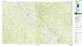 |
Opelika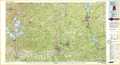 |
Thomaston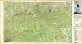 |
Montgomery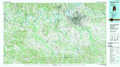 |
Tuskegee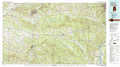 |
Americus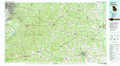 |
Greenville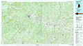 |
Troy |
Albany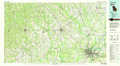 |
> Back to 32084a1 at 1:250,000 scale
> Back to U.S. Topo Maps home
1:24,000 Topo Quads covered by the spatial extent of this 100k map (Tuskegee)
|
Shorter 
|
La Place 
|
Tuskegee 
|
Little Texas 
|
Society Hill 
|
Marvyn 
|
Crawford 
|
Phenix City 
|
|
Chesson 
|
Hardaway 
|
Davisville 
|
Warriorstand 
|
Creek Stand 
|
Hatchechubbee 
|
Seale 
|
Fort Mitchell 
|
|
Fitzpatrick 
|
Thompson 
|
Union Springs 
|
Roba 
|
Hurtsboro 
|
Rutherford 
|
Pittsview 
|
Omaha 
|
|
China Grove 
|
Almeria 
|
Aberfoil 
|
Midway 
|
Comer 
|
Batesville 
|
Howe 
|
Twin Springs 
|
