Tyler Topo Map Texas
To zoom in, hover over the map of Tyler
USGS Topo Map 32095a1 - 1:100,000 scale
| Topo Map Name: | Tyler |
| USGS Topo Quad ID: | 32095a1 |
| Print Size: | ca. 39" wide x 24" high |
| Southeast Coordinates: | 32° N latitude / 95° W longitude |
| Map Center Coordinates: | 32.25° N latitude / 95.5° W longitude |
| U.S. State: | TX |
| Filename: | 32095a1.jpg |
| Download Map JPG Image: | Tyler topo map 1:100,000 scale |
| Map Type: | Topographic |
| Topo Series: | 30´x60´ |
| Map Scale: | 1:100,000 |
| Source of Map Images: | United States Geological Survey (USGS) |
| Alternate Map Versions: |
Tyler TX 1985, updated 1985 Download PDF Buy paper map Tyler TX 1991, updated 1991 Download PDF Buy paper map |
1:100,000 Topos surrounding Tyler
Dallas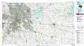 |
Mineola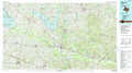 |
Marshall |
Corsicana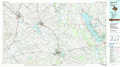 |
Tyler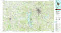 |
Henderson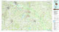 |
Mexia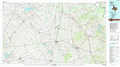 |
Palestine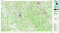 |
Nacogdoches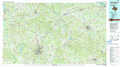 |
> Back to 32094a1 at 1:250,000 scale
> Back to U.S. Topo Maps home
1:24,000 Topo Quads covered by the spatial extent of this 100k map (Tyler)
|
Phalba 
|
Martins Mill 
|
Ben Wheeler 
|
Carroll 
|
Mount Sylvan 
|
Tyler North 
|
Winona 
|
Starrville 
|
|
Stockard 
|
Murchinson West 
|
Murchinson East 
|
Brownsboro 
|
Chandler 
|
Tyler South 
|
Bascom 
|
Hope Pond 
|
|
Mallard Hill 
|
Athens 
|
Leagueville 
|
Moore Station 
|
Saline Bay 
|
Bullard 
|
Troup West 
|
Troup East 
|
|
Cross Roads 
|
Coon Creek Lake 
|
La Rue 
|
Poynor 
|
Berryville 
|
Mount Selman 
|
Tecula 
|
Griffin 
|
