Long Beach Topo Map California
To zoom in, hover over the map of Long Beach
USGS Topo Map 33118e1 - 1:100,000 scale
| Topo Map Name: | Long Beach |
| USGS Topo Quad ID: | 33118e1 |
| Print Size: | ca. 39" wide x 24" high |
| Southeast Coordinates: | 33.5° N latitude / 118° W longitude |
| Map Center Coordinates: | 33.75° N latitude / 118.5° W longitude |
| U.S. State: | CA |
| Filename: | 33118e1.jpg |
| Download Map JPG Image: | Long Beach topo map 1:100,000 scale |
| Map Type: | Topographic |
| Topo Series: | 30´x60´ |
| Map Scale: | 1:100,000 |
| Source of Map Images: | United States Geological Survey (USGS) |
| Alternate Map Versions: |
Long Beach CA 1981, updated 1981 Download PDF Buy paper map Long Beach CA 1981, updated 1981 Download PDF Buy paper map Long Beach CA 1981, updated 1981 Download PDF Buy paper map |
1:100,000 Topos surrounding Long Beach
Santa Barbara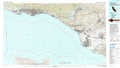 |
Los Angeles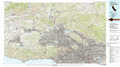 |
San Bernardino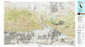 |
Laguna Harbor |
Long Beach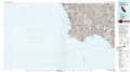 |
Santa Ana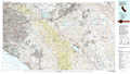 |
San Nicolas Island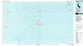 |
Santa Catalina Island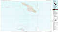 |
Oceanside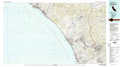 |
> Back to 33118a1 at 1:250,000 scale
> Back to U.S. Topo Maps home
1:24,000 Topo Quads covered by the spatial extent of this 100k map (Long Beach)
|
Venice 
|
Inglewood 
|
South Gate 
|
Whittier 
|
||||
|
Redondo Beach 
|
Torrance 
|
Long Beach 
|
Los Alamitos 
|
||||
|
San Pedro 
|
Seal Beach 
|
||||||
