Williams Topo Map Arizona
To zoom in, hover over the map of Williams
USGS Topo Map 35112a1 - 1:100,000 scale
| Topo Map Name: | Williams |
| USGS Topo Quad ID: | 35112a1 |
| Print Size: | ca. 39" wide x 24" high |
| Southeast Coordinates: | 35° N latitude / 112° W longitude |
| Map Center Coordinates: | 35.25° N latitude / 112.5° W longitude |
| U.S. State: | AZ |
| Filename: | 35112a1.jpg |
| Download Map JPG Image: | Williams topo map 1:100,000 scale |
| Map Type: | Topographic |
| Topo Series: | 30´x60´ |
| Map Scale: | 1:100,000 |
| Source of Map Images: | United States Geological Survey (USGS) |
| Alternate Map Versions: |
Williams AZ 1983, updated 1984 Download PDF Buy paper map Williams AZ 1983, updated 1984 Download PDF Buy paper map Williams AZ 1983, updated 1984 Download PDF Buy paper map |
1:100,000 Topos surrounding Williams
Peach Springs |
Valle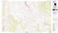 |
Cameron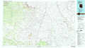 |
Valentine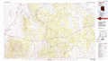 |
Williams |
Flagstaff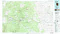 |
Bagdad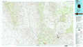 |
Prescott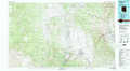 |
Sedona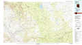 |
> Back to 35112a1 at 1:250,000 scale
> Back to U.S. Topo Maps home
1:24,000 Topo Quads covered by the spatial extent of this 100k map (Williams)
|
Red Mesa 
|
Trinity Mountain 
|
Mount Floyd 
|
Eagle Nest Mountain 
|
Stanford Tank 
|
Cataract Tank 
|
Howard Mesa 
|
Squaw Mountain 
|
|
Seligman West 
|
Seligman East 
|
Crookton 
|
Horse Trap Mesa 
|
Fitzgerald Hill 
|
Hearst Mountain 
|
Williams North 
|
Sitgreaves Mountain 
|
|
Purcell Canyon 
|
Turkey Canyon Ne 
|
Picacho Butte 
|
Cathedral Caves 
|
Ash Fork 
|
Mclellan Reservoir 
|
Williams South 
|
Davenport Hill 
|
|
Turkey Canyon 
|
Red Mountain 
|
South Butte 
|
Picacho Butte Se 
|
Meath Spring 
|
Matterhorn 
|
May Tank Pocket 
|
White Horse Lake 
|
