Valle Topo Map Arizona
To zoom in, hover over the map of Valle
USGS Topo Map 35112e1 - 1:100,000 scale
| Topo Map Name: | Valle |
| USGS Topo Quad ID: | 35112e1 |
| Print Size: | ca. 39" wide x 24" high |
| Southeast Coordinates: | 35.5° N latitude / 112° W longitude |
| Map Center Coordinates: | 35.75° N latitude / 112.5° W longitude |
| U.S. State: | AZ |
| Filename: | 35112e1.jpg |
| Download Map JPG Image: | Valle topo map 1:100,000 scale |
| Map Type: | Topographic |
| Topo Series: | 30´x60´ |
| Map Scale: | 1:100,000 |
| Source of Map Images: | United States Geological Survey (USGS) |
| Alternate Map Versions: |
Valle AZ 1983, updated 1983 Download PDF Buy paper map Valle AZ 1983, updated 1983 Download PDF Buy paper map |
1:100,000 Topos surrounding Valle
Mount Trumbull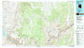 |
Grand Canyon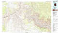 |
Tuba City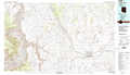 |
Peach Springs |
Valle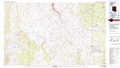 |
Cameron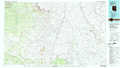 |
Valentine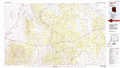 |
Williams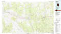 |
Flagstaff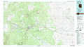 |
> Back to 35112a1 at 1:250,000 scale
> Back to U.S. Topo Maps home
1:24,000 Topo Quads covered by the spatial extent of this 100k map (Valle)
|
National Tank 
|
Supai Camp 
|
Hualapai Tank 
|
Baldy Basin 
|
Box K Ranch 
|
Metzger Tank 
|
Tusayan West 
|
Tusayan East 
|
|
Dike Tank 
|
Supai Camp Se 
|
Hazen Hole Tank 
|
Rosebud Tank 
|
Little Harpo Canyon 
|
Howard Hill 
|
Red Butte Sw 
|
Red Butte 
|
|
Rose Well Camp West 
|
Rose Well Camp East 
|
Black Tank 
|
Tin House 
|
Markham Dam 
|
Miller Tank 
|
Valle Tank 
|
Molly Ann Draw 
|
|
Rhodes Canyon 
|
Big Bud Tank 
|
Bishop Lake 
|
Howard Spring 
|
Red Hill Ranch 
|
Mixon Tank 
|
Howard Lake 
|
Hobble Tank 
|
