Paso Robles Topo Map California
To zoom in, hover over the map of Paso Robles
USGS Topo Map 35120e1 - 1:100,000 scale
| Topo Map Name: | Paso Robles |
| USGS Topo Quad ID: | 35120e1 |
| Print Size: | ca. 39" wide x 24" high |
| Southeast Coordinates: | 35.5° N latitude / 120° W longitude |
| Map Center Coordinates: | 35.75° N latitude / 120.5° W longitude |
| U.S. State: | CA |
| Filename: | 35120e1.jpg |
| Download Map JPG Image: | Paso Robles topo map 1:100,000 scale |
| Map Type: | Topographic |
| Topo Series: | 30´x60´ |
| Map Scale: | 1:100,000 |
| Source of Map Images: | United States Geological Survey (USGS) |
| Alternate Map Versions: |
Paso Robles CA 1989, updated 1989 Download PDF Buy paper map |
1:100,000 Topos surrounding Paso Robles
Point Sur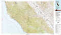 |
Coalinga |
Visalia |
Cambria |
Paso Robles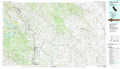 |
Delano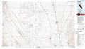 |
Point Estero |
San Luis Obispo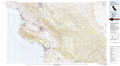 |
Taft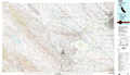 |
> Back to 35120a1 at 1:250,000 scale
> Back to U.S. Topo Maps home
1:24,000 Topo Quads covered by the spatial extent of this 100k map (Paso Robles)
|
Hames Valley 
|
Wunpost 
|
Valleton 
|
Stockdale Mountain 
|
Parkfield 
|
The Dark Hole 
|
Garza Peak 
|
Kettleman Plain 
|
|
Tierra Redondo Mountain 
|
Bradley 
|
San Miguel 
|
Ranchito Canyon 
|
Cholame Hills 
|
Cholame Valley 
|
Tent Hills 
|
Pyramid Hills 
|
|
Lime Mountain 
|
Adelaida 
|
Paso Robles 
|
Estrella 
|
Shandon 
|
Cholame 
|
Orchard Peak 
|
Sawtooth Ridge 
|
|
Cypress Mountain 
|
York Mountain 
|
Templeton 
|
Creston 
|
Shedd Canyon 
|
Camatta Canyon 
|
Holland Canyon 
|
Packwood Creek 
|
