Harrison Topo Map Arkansas
To zoom in, hover over the map of Harrison
USGS Topo Map 36093a1 - 1:100,000 scale
| Topo Map Name: | Harrison |
| USGS Topo Quad ID: | 36093a1 |
| Print Size: | ca. 39" wide x 24" high |
| Southeast Coordinates: | 36° N latitude / 93° W longitude |
| Map Center Coordinates: | 36.25° N latitude / 93.5° W longitude |
| U.S. States: | AR, MO |
| Filename: | 36093a1.jpg |
| Download Map JPG Image: | Harrison topo map 1:100,000 scale |
| Map Type: | Topographic |
| Topo Series: | 30´x60´ |
| Map Scale: | 1:100,000 |
| Source of Map Images: | United States Geological Survey (USGS) |
| Alternate Map Versions: |
Harrison AR 1985, updated 1985 Download PDF Buy paper map |
1:100,000 Topos surrounding Harrison
Neosho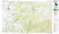 |
Table Rock Lake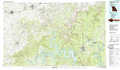 |
Ava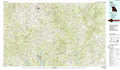 |
Fayetteville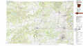 |
Harrison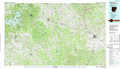 |
Bull Shoals Lake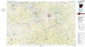 |
Stilwell |
Fly Gap Mountain |
Mountain View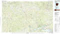 |
> Back to 36092a1 at 1:250,000 scale
> Back to U.S. Topo Maps home
1:24,000 Topo Quads covered by the spatial extent of this 100k map (Harrison)
|
Garfield 
|
Beaver 
|
Eureka Springs 
|
Grandview 
|
Blue Eye 
|
Denver 
|
Omaha 
|
Omaha Ne 
|
|
War Eagle 
|
Sandstone Mountain 
|
Rockhouse 
|
Berryville 
|
Green Forest 
|
Alpena 
|
Batavia 
|
Bergman 
|
|
Spring Valley 
|
Hindsville 
|
Forum 
|
Marble 
|
Osage 
|
Osage Ne 
|
Gaither 
|
Harrison 
|
|
Goshen 
|
Hartwell 
|
Huntsville 
|
Kingston 
|
Osage Sw 
|
Ponca 
|
Jasper 
|
Hasty 
|
