Kayenta Topo Map Arizona
To zoom in, hover over the map of Kayenta
USGS Topo Map 36110e1 - 1:100,000 scale
| Topo Map Name: | Kayenta |
| USGS Topo Quad ID: | 36110e1 |
| Print Size: | ca. 39" wide x 24" high |
| Southeast Coordinates: | 36.5° N latitude / 110° W longitude |
| Map Center Coordinates: | 36.75° N latitude / 110.5° W longitude |
| U.S. States: | AZ, UT |
| Filename: | 36110e1.jpg |
| Download Map JPG Image: | Kayenta topo map 1:100,000 scale |
| Map Type: | Topographic |
| Topo Series: | 30´x60´ |
| Map Scale: | 1:100,000 |
| Source of Map Images: | United States Geological Survey (USGS) |
| Alternate Map Versions: |
Kayenta AZ 1984, updated 1984 Download PDF Buy paper map |
1:100,000 Topos surrounding Kayenta
Smoky Mountain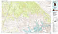 |
Navajo Mountain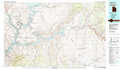 |
Bluff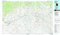 |
Glen Canyon Dam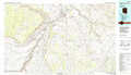 |
Kayenta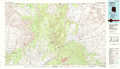 |
Rock Point |
Tuba City |
Pinon |
Canyon De Chelly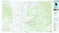 |
> Back to 36110a1 at 1:250,000 scale
> Back to U.S. Topo Maps home
1:24,000 Topo Quads covered by the spatial extent of this 100k map (Kayenta)
|
Chaiyahi Flat 
|
Chaiyahi Rim Ne 
|
Tall Mountain Nw 
|
Cattle Canyon 
|
Big Point 
|
Boot Mesa 
|
Mystery Valley 
|
Mitten Buttes 
|
|
Chaiyahi Rim Sw 
|
Chaiyahi Rim Se 
|
Oak Springs 
|
Tall Mountain 
|
Keet Seel Ruin 
|
Tseyi-Hatsosi 
|
Agathla Peak 
|
Baby Rocks 
|
|
Two Red Mesas 
|
Inscription House Ruin 
|
Shonto Nw 
|
Betatakin Ruin 
|
Marsh Pass 
|
Kayenta West 
|
Kayenta East 
|
Church Rock 
|
|
Square Butte 
|
Whirlwind Rock 
|
Shonto 
|
Shonto Se 
|
Long House Valley 
|
Marsh Pass Se 
|
Owl Spring 
|
Chilchinbito 
|
