Jerseyville Topo Map Illinois
To zoom in, hover over the map of Jerseyville
USGS Topo Map 39090a1 - 1:100,000 scale
| Topo Map Name: | Jerseyville |
| USGS Topo Quad ID: | 39090a1 |
| Print Size: | ca. 39" wide x 24" high |
| Southeast Coordinates: | 39° N latitude / 90° W longitude |
| Map Center Coordinates: | 39.25° N latitude / 90.5° W longitude |
| U.S. States: | IL, MO |
| Filename: | 39090a1.jpg |
| Download Map JPG Image: | Jerseyville topo map 1:100,000 scale |
| Map Type: | Topographic |
| Topo Series: | 30´x60´ |
| Map Scale: | 1:100,000 |
| Source of Map Images: | United States Geological Survey (USGS) |
| Alternate Map Versions: |
Jerseyville IL 1985, updated 1985 Download PDF Buy paper map Jerseyville IL 1985, updated 1985 Download PDF Buy paper map |
1:100,000 Topos surrounding Jerseyville
Quincy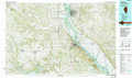 |
Meredosia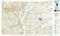 |
Springfield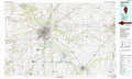 |
Mexico |
Jerseyville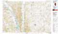 |
Litchfield |
Fulton |
Saint Louis |
Carlyle Lake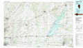 |
> Back to 39090a1 at 1:250,000 scale
> Back to U.S. Topo Maps home
1:24,000 Topo Quads covered by the spatial extent of this 100k map (Jerseyville)
|
Pleasant Hill West 
|
Pleasant Hill East 
|
Pearl West 
|
Pearl East 
|
Roodhouse West 
|
Roodhouse East 
|
Athensville 
|
Scottville 
|
|
Clarksville 
|
Annada 
|
Pleasant Dale Valley 
|
Kampsville 
|
Carrollton 
|
Daum 
|
Greenfield 
|
Hettick 
|
|
Auburn 
|
Elsberry 
|
Hamburg 
|
Hardin 
|
Boyer Creek 
|
Jerseyville North 
|
Medora 
|
Summerville 
|
|
Okete 
|
Luckett Ridge 
|
Foley 
|
Nutwood 
|
Otterville 
|
Jerseyville South 
|
Brighton 
|
Shipman 
|
