Nephi Topo Map Utah
To zoom in, hover over the map of Nephi
USGS Topo Map 39111e1 - 1:100,000 scale
| Topo Map Name: | Nephi |
| USGS Topo Quad ID: | 39111e1 |
| Print Size: | ca. 39" wide x 24" high |
| Southeast Coordinates: | 39.5° N latitude / 111° W longitude |
| Map Center Coordinates: | 39.75° N latitude / 111.5° W longitude |
| U.S. State: | UT |
| Filename: | 39111e1.jpg |
| Download Map JPG Image: | Nephi topo map 1:100,000 scale |
| Map Type: | Topographic |
| Topo Series: | 30´x60´ |
| Map Scale: | 1:100,000 |
| Source of Map Images: | United States Geological Survey (USGS) |
| Alternate Map Versions: |
Nephi UT 1981, updated 1981 Download PDF Buy paper map Nephi UT 1981, updated 1991 Download PDF Buy paper map Nephi UT 1981, updated 1991 Download PDF Buy paper map |
1:100,000 Topos surrounding Nephi
Rush Valley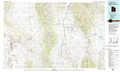 |
Provo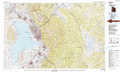 |
Duchesne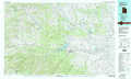 |
Lynndyl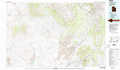 |
Nephi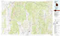 |
Price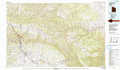 |
Delta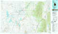 |
Manti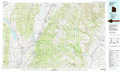 |
Huntington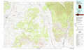 |
> Back to 39110a1 at 1:250,000 scale
> Back to U.S. Topo Maps home
1:24,000 Topo Quads covered by the spatial extent of this 100k map (Nephi)
|
Goshen 
|
Santaquin 
|
Payson Lakes 
|
Birdseye 
|
Thistle 
|
Mill Fork 
|
Tucker 
|
Soldier Summit 
|
|
Slate Jack Canyon 
|
Mona 
|
Nebo Basin 
|
Spencer Canyon 
|
Indianola 
|
C Canyon 
|
Scofield Reservoir 
|
Colton 
|
|
Sugarloaf 
|
Nephi 
|
Fountain Green North 
|
Big Hollow 
|
Fairview 
|
Fairview Lakes 
|
Scofield 
|
Jump Creek 
|
|
Juab 
|
Levan 
|
Fountain Green South 
|
Moroni 
|
Mount Pleasant 
|
Huntington Reservoir 
|
Candland Mountain 
|
Wattis 
|
