Danville Topo Map Illinois
To zoom in, hover over the map of Danville
USGS Topo Map 40087a1 - 1:100,000 scale
| Topo Map Name: | Danville |
| USGS Topo Quad ID: | 40087a1 |
| Print Size: | ca. 39" wide x 24" high |
| Southeast Coordinates: | 40° N latitude / 87° W longitude |
| Map Center Coordinates: | 40.25° N latitude / 87.5° W longitude |
| U.S. States: | IL, IN |
| Filename: | 40087a1.jpg |
| Download Map JPG Image: | Danville topo map 1:100,000 scale |
| Map Type: | Topographic |
| Topo Series: | 30´x60´ |
| Map Scale: | 1:100,000 |
| Source of Map Images: | United States Geological Survey (USGS) |
| Alternate Map Versions: |
Danville IL 1984, updated 1985 Download PDF Buy paper map Danville IL 1987, updated 1994 Download PDF Buy paper map |
1:100,000 Topos surrounding Danville
Fairbury |
Watseka |
Logansport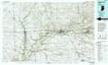 |
Champaign |
Danville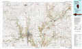 |
La Fayette |
Decatur |
Paris |
Indianapolis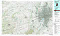 |
> Back to 40086a1 at 1:250,000 scale
> Back to U.S. Topo Maps home
1:24,000 Topo Quads covered by the spatial extent of this 100k map (Danville)
|
Rankin 
|
East Lynn 
|
Hoopeston 
|
Ambia 
|
Tab 
|
Pine Village 
|
Chatterton 
|
Otterbein 
|
|
Penfield 
|
Potomac 
|
Henning 
|
Bismarck 
|
West Lebanon 
|
Williamsport 
|
Attica 
|
Westpoint 
|
|
Royal 
|
Collison 
|
Danville Nw 
|
Danville Ne 
|
Covington 
|
Stone Bluff 
|
Mellott 
|
Wingate 
|
|
Homer 
|
Oakwood 
|
Danville Sw 
|
Danville Se 
|
Perrysville 
|
Veedersburg 
|
Hillsboro 
|
Waynetown 
|
