Cleveland South Topo Map Ohio
To zoom in, hover over the map of Cleveland South
USGS Topo Map 41081a1 - 1:100,000 scale
| Topo Map Name: | Cleveland South |
| USGS Topo Quad ID: | 41081a1 |
| Print Size: | ca. 39" wide x 24" high |
| Southeast Coordinates: | 41° N latitude / 81° W longitude |
| Map Center Coordinates: | 41.25° N latitude / 81.5° W longitude |
| U.S. State: | OH |
| Filename: | 41081a1.jpg |
| Download Map JPG Image: | Cleveland South topo map 1:100,000 scale |
| Map Type: | Topographic |
| Topo Series: | 30´x60´ |
| Map Scale: | 1:100,000 |
| Source of Map Images: | United States Geological Survey (USGS) |
| Alternate Map Versions: |
Cleveland South OH 1986, updated 1986 Download PDF Buy paper map Cleveland South OH 1994, updated 1994 Download PDF Buy paper map |
1:100,000 Topos surrounding Cleveland South
Put-In-Bay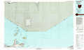 |
Cleveland North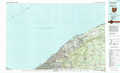 |
Ashtabula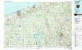 |
Lorain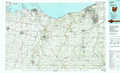 |
Cleveland South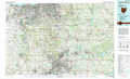 |
Youngstown |
Mansfield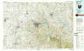 |
Canton |
East Liverpool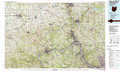 |
> Back to 41080a1 at 1:250,000 scale
> Back to U.S. Topo Maps home
1:24,000 Topo Quads covered by the spatial extent of this 100k map (Cleveland South)
|
North Olmsted 
|
Lakewood 
|
Cleveland South 
|
Shaker Heights 
|
Chagrin Falls 
|
South Russell 
|
Burton 
|
Middlefield 
|
|
West View 
|
Berea 
|
Broadview Heights 
|
Northfield 
|
Twinsburg 
|
Aurora 
|
Mantua 
|
Garrettsville 
|
|
Mallet Creek 
|
Medina 
|
West Richfield 
|
Peninsula 
|
Hudson 
|
Kent 
|
Ravenna 
|
Windham 
|
|
Westfield Center 
|
Seville 
|
Wadsworth 
|
Akron West 
|
Akron East 
|
Suffield 
|
Atwater 
|
Deerfield 
|