Gordon Topo Map Nebraska
To zoom in, hover over the map of Gordon
USGS Topo Map 42102e1 - 1:100,000 scale
| Topo Map Name: | Gordon |
| USGS Topo Quad ID: | 42102e1 |
| Print Size: | ca. 39" wide x 24" high |
| Southeast Coordinates: | 42.5° N latitude / 102° W longitude |
| Map Center Coordinates: | 42.75° N latitude / 102.5° W longitude |
| U.S. States: | NE, SD |
| Filename: | 42102e1.jpg |
| Download Map JPG Image: | Gordon topo map 1:100,000 scale |
| Map Type: | Topographic |
| Topo Series: | 30´x60´ |
| Map Scale: | 1:100,000 |
| Source of Map Images: | United States Geological Survey (USGS) |
| Alternate Map Versions: |
Gordon NE 1985, updated 1985 Download PDF Buy paper map Gordon NE 1985, updated 1989 Download PDF Buy paper map |
1:100,000 Topos surrounding Gordon
Hot Springs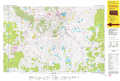 |
Pine Ridge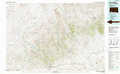 |
Martin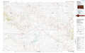 |
Crawford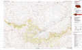 |
Gordon |
Cody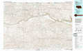 |
Hemingford |
Alliance |
Mullen |
> Back to 42102a1 at 1:250,000 scale
> Back to U.S. Topo Maps home
1:24,000 Topo Quads covered by the spatial extent of this 100k map (Gordon)
|
Isinglass Buttes 
|
Chadron Ne 
|
Beaver Wall 
|
Whiteclay 
|
Clinton Nw 
|
Clinton Ne 
|
Gordon Nw 
|
Hog Island 
|
|
Chadron East 
|
Bordeaux 
|
Whiteclay Sw 
|
Whiteclay Se 
|
Clinton Sw 
|
Clinton 
|
Gordon 
|
Gordon Se 
|
|
Chadron 3 Nw 
|
Chadron 3 Ne 
|
Hay Springs 
|
Hay Springs Ne 
|
Rushville 
|
Rushville Ne 
|
Rushville 4 Nw 
|
Rushville 4 Ne 
|
|
Chadron 3 Sw 
|
Chadron 3 Se 
|
Hay Springs Sw 
|
Hay Springs Se 
|
Rushville Sw 
|
Rushville Se 
|
Rushville 4 Sw 
|
Rushville 4 Se 
|
