Twin Falls Topo Map Idaho
To zoom in, hover over the map of Twin Falls
USGS Topo Map 42114e1 - 1:100,000 scale
| Topo Map Name: | Twin Falls |
| USGS Topo Quad ID: | 42114e1 |
| Print Size: | ca. 39" wide x 24" high |
| Southeast Coordinates: | 42.5° N latitude / 114° W longitude |
| Map Center Coordinates: | 42.75° N latitude / 114.5° W longitude |
| U.S. State: | ID |
| Filename: | 42114e1.jpg |
| Download Map JPG Image: | Twin Falls topo map 1:100,000 scale |
| Map Type: | Topographic |
| Topo Series: | 30´x60´ |
| Map Scale: | 1:100,000 |
| Source of Map Images: | United States Geological Survey (USGS) |
| Alternate Map Versions: | none available in database |
1:100,000 Topos surrounding Twin Falls
Mountain Home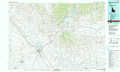 |
Fairfield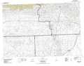 |
Craters Of The Moon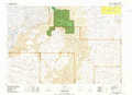 |
Glenns Ferry |
Twin Falls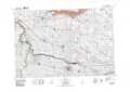 |
Lake Walcott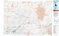 |
Sheep Creek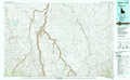 |
Rogerson |
Oakley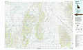 |
> Back to 42114a1 at 1:250,000 scale
> Back to U.S. Topo Maps home
1:24,000 Topo Quads covered by the spatial extent of this 100k map (Twin Falls)
|
Bliss 
|
Gooding Butte 
|
Gooding 
|
Tunupa 
|
Shoshone 
|
Dietrich 
|
Dietrich Butte 
|
Owinza 
|
|
Hagerman 
|
Tuttle 
|
Wendell 
|
Gooding Se 
|
Shoshone Sw 
|
Shoshone Se 
|
Star Lake 
|
Owinza Butte 
|
|
Yahoo Creek 
|
Thousand Springs 
|
Niagara Springs 
|
Jerome 
|
Falls City 
|
Twin Falls Ne 
|
Hunt 
|
Eden Ne 
|
|
Balanced Rock 
|
Buhl 
|
Clover 
|
Filer 
|
Twin Falls 
|
Kimberly 
|
Eden 
|
Milner 
|
