Medford Topo Map Oregon
To zoom in, hover over the map of Medford
USGS Topo Map 42122a1 - 1:100,000 scale
| Topo Map Name: | Medford |
| USGS Topo Quad ID: | 42122a1 |
| Print Size: | ca. 39" wide x 24" high |
| Southeast Coordinates: | 42° N latitude / 122° W longitude |
| Map Center Coordinates: | 42.25° N latitude / 122.5° W longitude |
| U.S. States: | OR, CA |
| Filename: | 42122a1.jpg |
| Download Map JPG Image: | Medford topo map 1:100,000 scale |
| Map Type: | Topographic |
| Topo Series: | 30´x60´ |
| Map Scale: | 1:100,000 |
| Source of Map Images: | United States Geological Survey (USGS) |
| Alternate Map Versions: |
Medford OR 1978, updated 1994 Download PDF Buy paper map |
1:100,000 Topos surrounding Medford
Canyonville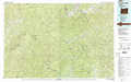 |
Crater Lake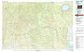 |
Williamson River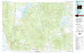 |
Grants Pass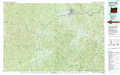 |
Medford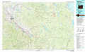 |
Klamath Falls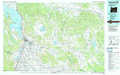 |
Happy Camp |
Yreka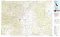 |
Tulelake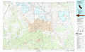 |
> Back to 42122a1 at 1:250,000 scale
> Back to U.S. Topo Maps home
1:24,000 Topo Quads covered by the spatial extent of this 100k map (Medford)
|
Sams Valley 
|
Eagle Point 
|
Brownsboro 
|
Lakecreek 
|
Willow Lake 
|
Mount Mcloughlin 
|
Lake Of The Woods North 
|
Pelican Bay 
|
|
Medford West 
|
Medford East 
|
Rio Canyon 
|
Grizzly Peak 
|
Robinson Butte 
|
Brown Mountain 
|
Lake Of The Woods South 
|
Aspen Lake 
|
|
Sterling Creek 
|
Talent 
|
Ashland 
|
Emigrant Lake 
|
Hyatt Reservoir 
|
Little Chinquapin Mountain 
|
Surveyor Mountain 
|
Spencer Creek 
|
|
Dutchman Peak 
|
Siskiyou Peak 
|
Mount Ashland 
|
Siskiyou Pass 
|
Soda Mountain 
|
Parker Mountain 
|
Mule Hill 
|
Chicken Hills 
|
