Canyonville Topo Map Oregon
To zoom in, hover over the map of Canyonville
USGS Topo Map 42123e1 - 1:100,000 scale
| Topo Map Name: | Canyonville |
| USGS Topo Quad ID: | 42123e1 |
| Print Size: | ca. 39" wide x 24" high |
| Southeast Coordinates: | 42.5° N latitude / 123° W longitude |
| Map Center Coordinates: | 42.75° N latitude / 123.5° W longitude |
| U.S. State: | OR |
| Filename: | 42123e1.jpg |
| Download Map JPG Image: | Canyonville topo map 1:100,000 scale |
| Map Type: | Topographic |
| Topo Series: | 30´x60´ |
| Map Scale: | 1:100,000 |
| Source of Map Images: | United States Geological Survey (USGS) |
| Alternate Map Versions: |
Canyonville OR 1989, updated 1989 Download PDF Buy paper map Canyonville OR 1989, updated 1989 Download PDF Buy paper map |
1:100,000 Topos surrounding Canyonville
Coos Bay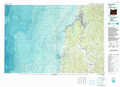 |
Roseburg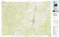 |
Diamond Lake |
Port Orford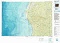 |
Canyonville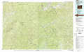 |
Crater Lake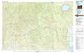 |
Gold Beach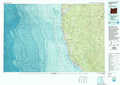 |
Grants Pass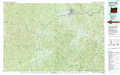 |
Medford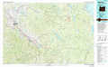 |
> Back to 42122a1 at 1:250,000 scale
> Back to U.S. Topo Maps home
1:24,000 Topo Quads covered by the spatial extent of this 100k map (Canyonville)
|
Rasler Creek 
|
Bone Mountain 
|
Chipmunk Ridge 
|
Live Oak Mountain 
|
Nickel Mountain 
|
Canyonville 
|
Days Creek 
|
Milo 
|
|
Eden Ridge Valley 
|
Mount Bolivar 
|
Dutchman Butte 
|
Rabbit Mountain 
|
Mccullough Creek 
|
Quines Creek 
|
Starvout Creek 
|
Cedar Springs Mountain 
|
|
Marial 
|
Kelsey Peak 
|
Bunker Creek 
|
Mount Reuben 
|
Glendale 
|
Golden 
|
King Mountain 
|
Skeleton Mountain 
|
|
Brandy Peak 
|
Hobson Horn 
|
Mount Peavine 
|
Galice 
|
Merlin 
|
Sexton Mountain 
|
Wimer 
|
Mcconville Peak 
|
