Albert Lea Topo Map Minnesota
To zoom in, hover over the map of Albert Lea
USGS Topo Map 43093e1 - 1:100,000 scale
| Topo Map Name: | Albert Lea |
| USGS Topo Quad ID: | 43093e1 |
| Print Size: | ca. 39" wide x 24" high |
| Southeast Coordinates: | 43.5° N latitude / 93° W longitude |
| Map Center Coordinates: | 43.75° N latitude / 93.5° W longitude |
| U.S. State: | MN |
| Filename: | 43093e1.jpg |
| Download Map JPG Image: | Albert Lea topo map 1:100,000 scale |
| Map Type: | Topographic |
| Topo Series: | 30´x60´ |
| Map Scale: | 1:100,000 |
| Source of Map Images: | United States Geological Survey (USGS) |
| Alternate Map Versions: |
Albert Lea MN 1985, updated 1985 Download PDF Buy paper map Albert Lea MN 1985, updated 1994 Download PDF Buy paper map |
1:100,000 Topos surrounding Albert Lea
New Ulm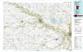 |
Faribault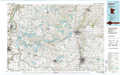 |
Rochester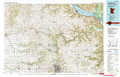 |
Fairmont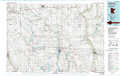 |
Albert Lea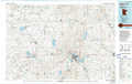 |
Austin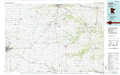 |
Estherville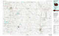 |
Mason City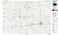 |
Charles City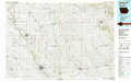 |
> Back to 43092a1 at 1:250,000 scale
> Back to U.S. Topo Maps home
1:24,000 Topo Quads covered by the spatial extent of this 100k map (Albert Lea)
|
Mapleton 
|
Mapleton Ne 
|
Waldorf 
|
Otisco 
|
New Richland 
|
Hope 
|
Steele Center 
|
Bixby 
|
|
Easton 
|
Minnesota Lake 
|
Matawan 
|
Freeborn 
|
Hartland 
|
Ellendale 
|
Hollandale 
|
Blooming Prairie 
|
|
Oza Tanka Lakebed 
|
Brush Creek 
|
Wells 
|
Alden 
|
Albert Lea West 
|
Albert Lea East 
|
Hayward 
|
Austin West 
|
|
Frost 
|
Bricelyn 
|
Kiester 
|
Conger 
|
Emmons 
|
Glenville 
|
Myrtle 
|
London 
|
