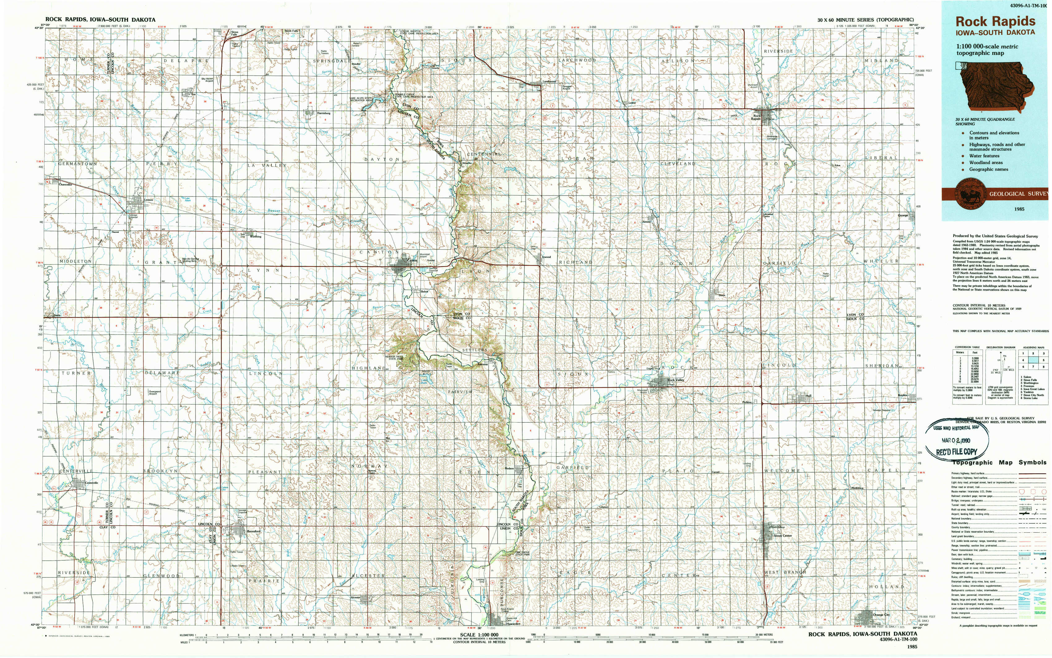
Rock Rapids Topo Map Iowa
To zoom in, hover over the map of Rock Rapids
USGS Topo Map 43096a1 - 1:100,000 scale
| Topo Map Name: | Rock Rapids |
| USGS Topo Quad ID: | 43096a1 |
| Print Size: | ca. 39" wide x 24" high |
| Southeast Coordinates: | 43° N latitude / 96° W longitude |
| Map Center Coordinates: | 43.25° N latitude / 96.5° W longitude |
| U.S. States: | IA, SD |
| Filename: | 43096a1.jpg |
| Download Map JPG Image: | Rock Rapids topo map 1:100,000 scale |
| Map Type: | Topographic |
| Topo Series: | 30´x60´ |
| Map Scale: | 1:100,000 |
| Source of Map Images: | United States Geological Survey (USGS) |
| Alternate Map Versions: |
Rock Rapids IA 1985, updated 1985 Download PDF Buy paper map Rock Rapids IA 1985, updated 1989 Download PDF Buy paper map |
1:100,000 Topos surrounding Rock Rapids
Salem |
Sioux Falls |
Worthington |
Freeman |
Rock Rapids |
Iowa Great Lakes |
Yankton |
Sioux City North |
Storm Lake |
> Back to 43096a1 at 1:250,000 scale
> Back to U.S. Topo Maps home
1:24,000 Topo Quads covered by the spatial extent of this 100k map (Rock Rapids)
|
Lennox Nw 
|
Tea 
|
Harrisburg 
|
Klondike 
|
Larchwood 
|
Lester 
|
Rock Rapids 
|
Edna 
|
|
Lennox 
|
Worthing 
|
Canton Sw 
|
Canton 
|
Inwood 
|
Alvord 
|
Doon 
|
George West 
|
|
Beresford Nw 
|
Beresford Ne 
|
Alcester Nw 
|
Alcester Ne 
|
Fairview 
|
Rock Valley 
|
Hull 
|
Boyden 
|
|
Centerville 
|
Beresford 
|
Alcester 
|
Alcester Se 
|
Hawarden North 
|
Lebanon 
|
Sioux Center 
|
Orange City 
|