Appleton Topo Map Wisconsin
To zoom in, hover over the map of Appleton
USGS Topo Map 44088a1 - 1:100,000 scale
| Topo Map Name: | Appleton |
| USGS Topo Quad ID: | 44088a1 |
| Print Size: | ca. 39" wide x 24" high |
| Southeast Coordinates: | 44° N latitude / 88° W longitude |
| Map Center Coordinates: | 44.25° N latitude / 88.5° W longitude |
| U.S. State: | WI |
| Filename: | 44088a1.jpg |
| Download Map JPG Image: | Appleton topo map 1:100,000 scale |
| Map Type: | Topographic |
| Topo Series: | 30´x60´ |
| Map Scale: | 1:100,000 |
| Source of Map Images: | United States Geological Survey (USGS) |
| Alternate Map Versions: |
Appleton WI 1984, updated 1985 Download PDF Buy paper map Appleton WI 1984, updated 1989 Download PDF Buy paper map |
1:100,000 Topos surrounding Appleton
Wausau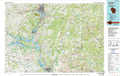 |
Shawano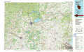 |
Sturgeon Bay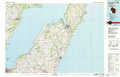 |
Wisconsin Rapids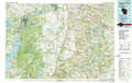 |
Appleton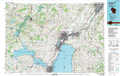 |
Manitowoc |
Wisconsin Dells |
Fond Du Lac |
Sheboygan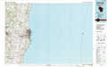 |
> Back to 44088a1 at 1:250,000 scale
> Back to U.S. Topo Maps home
1:24,000 Topo Quads covered by the spatial extent of this 100k map (Appleton)
|
Manawa 
|
Northport 
|
New London 
|
Shiocton 
|
Black Creek 
|
Freedom 
|
Oneida South 
|
De Pere 
|
|
Weyauwega 
|
Readfield 
|
Hortonville 
|
Greenville 
|
Appleton 
|
Kaukauna 
|
Wrightstown 
|
Greenleaf 
|
|
Poy Sippi 
|
Lake Poygan 
|
Oshkosh Nw 
|
Oshkosh Ne 
|
Neenah 
|
Sherwood 
|
Hilbert 
|
Brillion 
|
|
Auroraville 
|
Eureka 
|
Omro 
|
Oshkosh 
|
Indian Point 
|
Stockbridge 
|
Chilton 
|
Potter 
|
