Birney Topo Map Montana
To zoom in, hover over the map of Birney
USGS Topo Map 45106a1 - 1:100,000 scale
| Topo Map Name: | Birney |
| USGS Topo Quad ID: | 45106a1 |
| Print Size: | ca. 39" wide x 24" high |
| Southeast Coordinates: | 45° N latitude / 106° W longitude |
| Map Center Coordinates: | 45.25° N latitude / 106.5° W longitude |
| U.S. State: | MT |
| Filename: | 45106a1.jpg |
| Download Map JPG Image: | Birney topo map 1:100,000 scale |
| Map Type: | Topographic |
| Topo Series: | 30´x60´ |
| Map Scale: | 1:100,000 |
| Source of Map Images: | United States Geological Survey (USGS) |
| Alternate Map Versions: |
Birney MT 1980, updated 1980 Download PDF Buy paper map |
1:100,000 Topos surrounding Birney
Hardin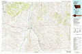 |
Lame Deer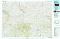 |
Powderville |
Lodge Grass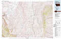 |
Birney |
Broadus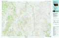 |
Burgess Junction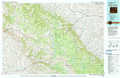 |
Sheridan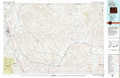 |
Recluse |
> Back to 45106a1 at 1:250,000 scale
> Back to U.S. Topo Maps home
1:24,000 Topo Quads covered by the spatial extent of this 100k map (Birney)
|
Birdseye Spring 
|
Bull Creek Lookout 
|
Cook Creek Butte 
|
Clubfoot Creek 
|
Birney Day School 
|
Green Creek 
|
King Mountain 
|
Yager Butte 
|
|
Kirby 
|
Taintor Desert 
|
Birney Sw 
|
Birney 
|
Browns Mountain 
|
Poker Jim Butte 
|
Fort Howes 
|
Goodspeed Butte 
|
|
Half Moon Hill 
|
Tongue River Dam 
|
Spring Gulch 
|
Lacey Gulch 
|
Stroud Creek 
|
Hamilton Draw 
|
Otter 
|
Reanus Cone 
|
|
Pearl School 
|
Decker 
|
Holmes Ranch 
|
Pine Butte School 
|
Forks Ranch 
|
Quietus 
|
Bear Creek School 
|
Sayle Hall 
|
