L'Anse Topo Map Michigan
To zoom in, hover over the map of L'Anse
USGS Topo Map 46088e1 - 1:100,000 scale
| Topo Map Name: | L'Anse |
| USGS Topo Quad ID: | 46088e1 |
| Print Size: | ca. 39" wide x 24" high |
| Southeast Coordinates: | 46.5° N latitude / 88° W longitude |
| Map Center Coordinates: | 46.75° N latitude / 88.5° W longitude |
| U.S. State: | MI |
| Filename: | 46088e1.jpg |
| Download Map JPG Image: | L'Anse topo map 1:100,000 scale |
| Map Type: | Topographic |
| Topo Series: | 30´x60´ |
| Map Scale: | 1:100,000 |
| Source of Map Images: | United States Geological Survey (USGS) |
| Alternate Map Versions: |
L'Anse MI 1991, updated 1991 Download PDF Buy paper map L'Anse MI 1991, updated 1991 Download PDF Buy paper map |
1:100,000 Topos surrounding L'Anse
North Of Ontonagon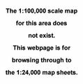 |
Hancock |
Copper Harbor |
Ontonagon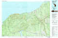 |
L'Anse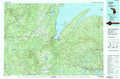 |
Marquette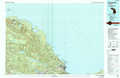 |
Wakefield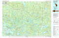 |
Iron River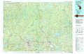 |
Gwinn |
> Back to 46088a1 at 1:250,000 scale
> Back to U.S. Topo Maps home
1:24,000 Topo Quads covered by the spatial extent of this 100k map (L'Anse)
|
Winona North 
|
Donken 
|
Pine Lake 
|
Otter Lake 
|
Portage Entry 
|
Keweenaw Bay Ne 
|
Skanee North 
|
Glovers Corner 
|
|
Winona South 
|
Nisula 
|
Pelkie 
|
Bear Town 
|
L'Anse 
|
Aura 
|
Skanee South 
|
Mccomb Corner 
|
|
Rousseau 
|
Vista Falls 
|
Prickett Lake 
|
Baraga Plains 
|
Alberta 
|
Herman 
|
Mount Curwood 
|
Summit Lake 
|
|
Sparrows Rapids 
|
Echo Lake 
|
Sidnaw 
|
Covington 
|
Vermilac 
|
Nestoria 
|
Three Lakes 
|
Michigamme 
|