Tacoma Topo Map Washington
To zoom in, hover over the map of Tacoma
USGS Topo Map 47122a1 - 1:100,000 scale
| Topo Map Name: | Tacoma |
| USGS Topo Quad ID: | 47122a1 |
| Print Size: | ca. 39" wide x 24" high |
| Southeast Coordinates: | 47° N latitude / 122° W longitude |
| Map Center Coordinates: | 47.25° N latitude / 122.5° W longitude |
| U.S. State: | WA |
| Filename: | 47122a1.jpg |
| Download Map JPG Image: | Tacoma topo map 1:100,000 scale |
| Map Type: | Topographic |
| Topo Series: | 30´x60´ |
| Map Scale: | 1:100,000 |
| Source of Map Images: | United States Geological Survey (USGS) |
| Alternate Map Versions: |
Tacoma WA 1975, updated 1977 Download PDF Buy paper map Tacoma WA 1991, updated 1991 Download PDF Buy paper map |
1:100,000 Topos surrounding Tacoma
Mount Olympus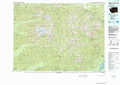 |
Seattle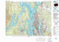 |
Skykomish River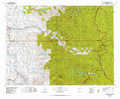 |
Shelton |
Tacoma |
Snoqualmie Pass |
Chehalis River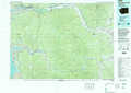 |
Centralia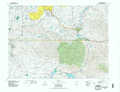 |
Mount Rainier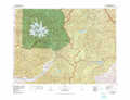 |
> Back to 47122a1 at 1:250,000 scale
> Back to U.S. Topo Maps home
1:24,000 Topo Quads covered by the spatial extent of this 100k map (Tacoma)
|
Lake Wooten 
|
Belfair 
|
Burley 
|
Olalla 
|
Vashon 
|
Des Moines 
|
Renton 
|
Maple Valley 
|
|
Mason Lake 
|
Vaughn 
|
Fox Island 
|
Gig Harbor 
|
Tacoma North 
|
Poverty Bay 
|
Auburn 
|
Black Diamond 
|
|
Squaxin Island 
|
Longbranch 
|
Mcneil Island 
|
Steilacoom 
|
Tacoma South 
|
Puyallup 
|
Sumner 
|
Buckley 
|
|
Olympia 
|
Lacey 
|
Nisqually 
|
Fort Lewis 
|
Spanaway 
|
Frederickson 
|
Orting 
|
Wilkeson 
|
