Glasgow Topo Map Montana
To zoom in, hover over the map of Glasgow
USGS Topo Map 48106a1 - 1:100,000 scale
| Topo Map Name: | Glasgow |
| USGS Topo Quad ID: | 48106a1 |
| Print Size: | ca. 39" wide x 24" high |
| Southeast Coordinates: | 48° N latitude / 106° W longitude |
| Map Center Coordinates: | 48.25° N latitude / 106.5° W longitude |
| U.S. State: | MT |
| Filename: | 48106a1.jpg |
| Download Map JPG Image: | Glasgow topo map 1:100,000 scale |
| Map Type: | Topographic |
| Topo Series: | 30´x60´ |
| Map Scale: | 1:100,000 |
| Source of Map Images: | United States Geological Survey (USGS) |
| Alternate Map Versions: |
Glasgow MT 1984, updated 1984 Download PDF Buy paper map |
1:100,000 Topos surrounding Glasgow
Whitewater |
Opheim |
Scobey |
Malta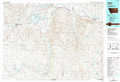 |
Glasgow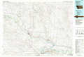 |
Wolf Point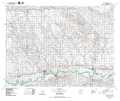 |
Fort Peck Lake West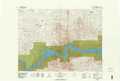 |
Fort Peck Lake East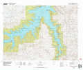 |
Richey |
> Back to 48106a1 at 1:250,000 scale
> Back to U.S. Topo Maps home
1:24,000 Topo Quads covered by the spatial extent of this 100k map (Glasgow)
|
Ellsworth Coulee 
|
Tampico Ne 
|
Cornwell Reservoir 
|
Chapman Coulee Ne 
|
Lookout 
|
Bullhead Reservoir 
|
Spring Valley West 
|
Spring Valley East 
|
|
Vandalia 
|
Tampico 
|
Chapman Coulee 
|
Hawk Coulee 
|
Uhlan Coulee 
|
Sargent Creek 
|
Spring Creek Sw 
|
Hauck Coulee 
|
|
Billick Coulee 
|
Engstrom Ranch 
|
Glasgow 
|
Whately 
|
Lindeke Coulee 
|
Nashua 
|
Milk River Coulee 
|
Dubbe Reservoir 
|
|
Miller Coulee West 
|
Miller Coulee East 
|
Blanchard Ranch 
|
Wheeler 
|
Fort Peck 
|
Milk River Hills 
|
Kintyre 
|
Frazer 
|
