Robinson Mountain Topo Map Washington
To zoom in, hover over the map of Robinson Mountain
USGS Topo Map 48120e1 - 1:100,000 scale
| Topo Map Name: | Robinson Mountain |
| USGS Topo Quad ID: | 48120e1 |
| Print Size: | ca. 39" wide x 24" high |
| Southeast Coordinates: | 48.5° N latitude / 120° W longitude |
| Map Center Coordinates: | 48.75° N latitude / 120.5° W longitude |
| U.S. State: | WA |
| Filename: | 48120e1.jpg |
| Download Map JPG Image: | Robinson Mountain topo map 1:100,000 scale |
| Map Type: | Topographic |
| Topo Series: | 30´x60´ |
| Map Scale: | 1:100,000 |
| Source of Map Images: | United States Geological Survey (USGS) |
| Alternate Map Versions: | none available in database |
1:100,000 Topos surrounding Robinson Mountain
Mount Baker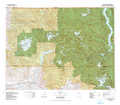 |
Robinson Mountain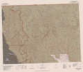 |
Oroville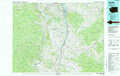 |
Sauk River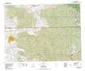 |
Twisp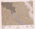 |
Omak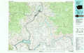 |
> Back to 48120a1 at 1:250,000 scale
> Back to U.S. Topo Maps home
1:24,000 Topo Quads covered by the spatial extent of this 100k map (Robinson Mountain)
|
Skagit Peak 
|
Castle Peak 
|
Frosty Creek 
|
Tatoosh Buttes 
|
Ashnola Mountain 
|
Ashnola Pass 
|
Remmel Mountain 
|
Bauerman Ridge 
|
|
Jack Mountain 
|
Shull Mountain 
|
Pasayten Peak 
|
Mount Lago 
|
Lost Peak 
|
Billy Goat Mountain 
|
Mount Barney 
|
Coleman Peak 
|
|
Crater Mountain 
|
Azurite Peak 
|
Slate Peak 
|
Robinson Mountain 
|
Mcleod Mountain 
|
Sweetgrass Butte 
|
Doe Mountain 
|
Spur Peak 
|
|
Mount Logan 
|
Mount Arriva 
|
Washington Pass 
|
Silver Star Mountain 
|
Mazama 
|
Rendevous Mountain 
|
Lewis Butte 
|
Pearrygin Peak 
|
