Long Key Topo Map Florida
To zoom in, hover over the map of Long Key
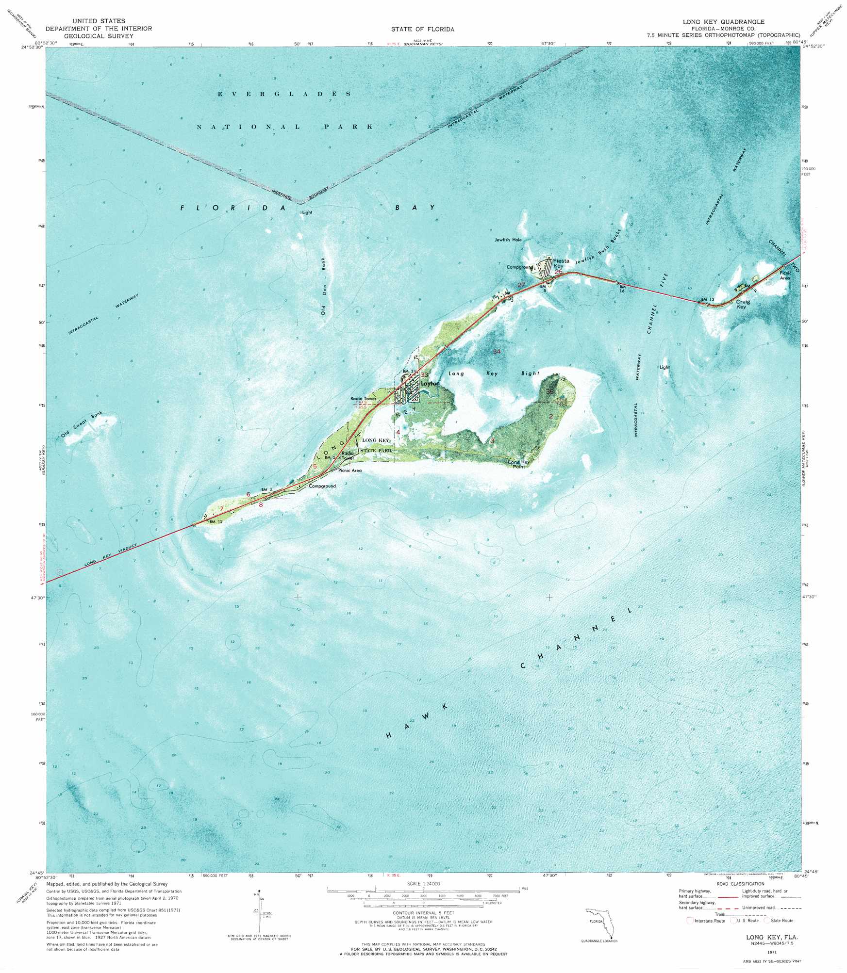
USGS Topo Quad 24080g7 - 1:24,000 scale
| Topo Map Name: | Long Key |
| USGS Topo Quad ID: | 24080g7 |
| Print Size: | ca. 21 1/4" wide x 27" high |
| Southeast Coordinates: | 24.75° N latitude / 80.75° W longitude |
| Map Center Coordinates: | 24.8125° N latitude / 80.8125° W longitude |
| U.S. State: | FL |
| Filename: | P24080G7.jpg |
| Download Map JPG Image: | Long Key topo map 1:24,000 scale |
| Map Type: | Orthophoto |
| Topo Series: | 7.5´ |
| Map Scale: | 1:24,000 |
| Source of Map Images: | United States Geological Survey (USGS) |
| Alternate Map Versions: |
Long Key FL 1971, updated 1973 Download PDF Buy paper map Long Key FL 2012 Download PDF Buy paper map Long Key FL 2015 Download PDF Buy paper map |
1:24,000 Topo Quads surrounding Long Key
Sandy Key |
Clive Key |
Pelican Keys |
Calusa Keys |
Tavernier |
East Bahia Honda Key Ne |
Schooner Bank |
Buchanan Keys |
Upper Matecumbe Key |
Plantation Key |
Bamboo Key |
Grassy Key |
Long Key |
Lower Matecumbe Key |
|
Marathon |
Crawl Key |
|||
> Back to 24080e1 at 1:100,000 scale
> Back to 24080a1 at 1:250,000 scale
> Back to U.S. Topo Maps home
Long Key topo map: Gazetteer
Long Key: Bars
Jewfish Bush Banks elevation 0m 0′Old Dan Bank elevation 0m 0′
Old Sweat Bank elevation 0m 0′
Tennessee Reef elevation 0m 0′
Tennessee Reef elevation 0m 0′
Long Key: Bays
Jewfish Hole elevation 0m 0′Long Key Bight elevation 0m 0′
Long Key: Bridges
Long Key Viaduct elevation 0m 0′Long Key: Capes
Long Key Point elevation 0m 0′Long Key: Channels
Channel Five elevation 0m 0′Channel Two elevation 0m 0′
Hawk Channel elevation 0m 0′
Long Key: Islands
Craig Key elevation 1m 3′Fiesta Key elevation 0m 0′
Long Key elevation 1m 3′
Long Key: Parks
Long Key State Park elevation 0m 0′Long Key: Populated Places
Craig (historical) elevation 2m 6′Layton elevation 0m 0′
Long Key: Post Offices
Craig Post Office (historical) elevation 7m 22′Long Key Post Office (historical) elevation 0m 0′
Long Key digital topo map on disk
Buy this Long Key topo map showing relief, roads, GPS coordinates and other geographical features, as a high-resolution digital map file on DVD: