Plantation Key Topo Map Florida
To zoom in, hover over the map of Plantation Key
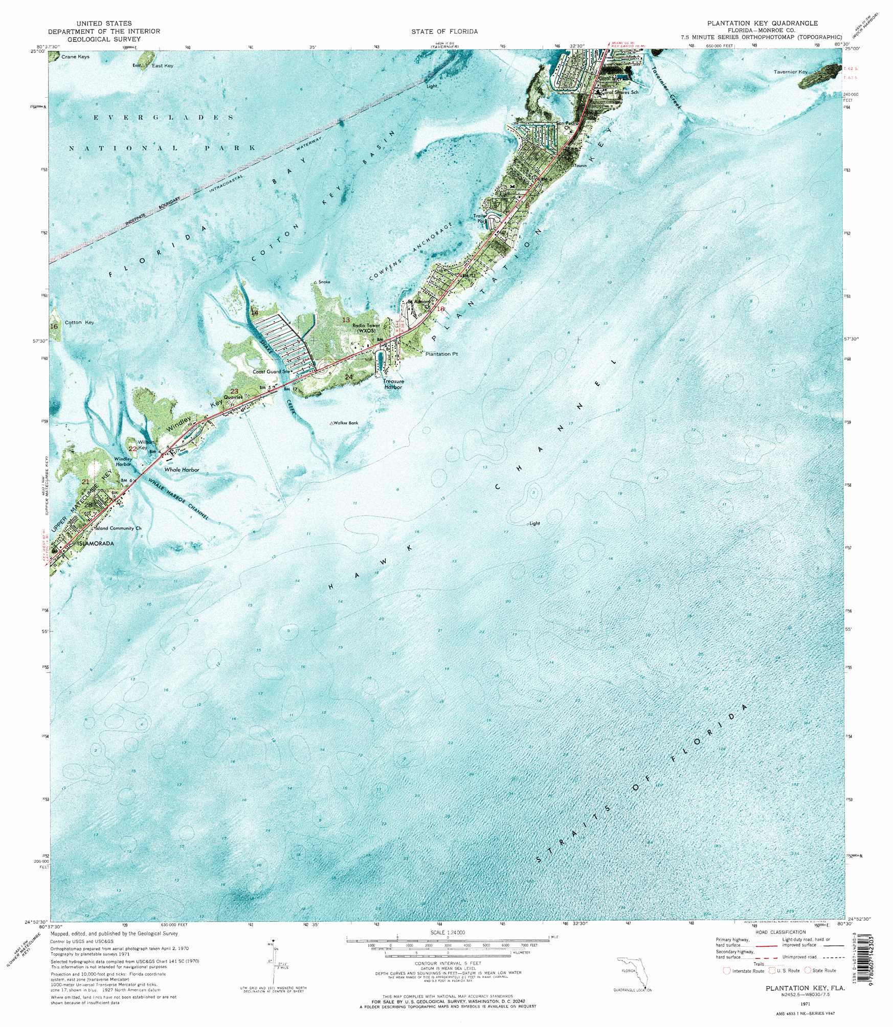
USGS Topo Quad 24080h5 - 1:24,000 scale
| Topo Map Name: | Plantation Key |
| USGS Topo Quad ID: | 24080h5 |
| Print Size: | ca. 21 1/4" wide x 27" high |
| Southeast Coordinates: | 24.875° N latitude / 80.5° W longitude |
| Map Center Coordinates: | 24.9375° N latitude / 80.5625° W longitude |
| U.S. State: | FL |
| Filename: | P24080H5.jpg |
| Download Map JPG Image: | Plantation Key topo map 1:24,000 scale |
| Map Type: | Orthophoto |
| Topo Series: | 7.5´ |
| Map Scale: | 1:24,000 |
| Source of Map Images: | United States Geological Survey (USGS) |
| Alternate Map Versions: |
Plantation Key FL 1971, updated 1973 Download PDF Buy paper map Plantation Key FL 1971, updated 1973 Download PDF Buy paper map Plantation Key FL 2012 Download PDF Buy paper map Plantation Key FL 2015 Download PDF Buy paper map |
1:24,000 Topo Quads surrounding Plantation Key
West Lake |
Madeira Bay |
Joe Bay |
Blackwater Sound |
Garden Cove |
Pelican Keys |
Calusa Keys |
Tavernier |
Rock Harbor |
|
Buchanan Keys |
Upper Matecumbe Key |
Plantation Key |
||
Long Key |
Lower Matecumbe Key |
|||
> Back to 24080e1 at 1:100,000 scale
> Back to 24080a1 at 1:250,000 scale
> Back to U.S. Topo Maps home
Plantation Key topo map: Gazetteer
Plantation Key: Airports
Holiday Isle Seaplane Base elevation 0m 0′Mariners Hospital Medical Emergency Heliport elevation 2m 6′
Plantation Key Seaplane Base elevation 0m 0′
Plantation Key: Bars
Crocker Reef elevation 0m 0′Davis Reef elevation 0m 0′
Hen and Chickens elevation 0m 0′
Hen and Chickens elevation 0m 0′
Islamorada Underwater Coral Gardens elevation 0m 0′
The Rocks elevation 0m 0′
Plantation Key: Bays
Cotton Key Basin elevation 0m 0′Treasure Harbor elevation 0m 0′
Whale Harbor elevation 0m 0′
Windley Harbor elevation 0m 0′
Plantation Key: Capes
Plantation Point elevation 0m 0′Plantation Key: Channels
Whale Harbor Channel elevation 0m 0′Plantation Key: Guts
Snake Creek elevation 0m 0′Plantation Key: Harbors
Cowpens Anchorage elevation 0m 0′Plantation Key: Islands
Cotton Key elevation 0m 0′East Key elevation 0m 0′
Kalteux Key elevation 0m 0′
Plantation Key elevation 3m 9′
Tavernier Key elevation 0m 0′
Wilson Key elevation 0m 0′
Windley Key elevation 1m 3′
Plantation Key: Populated Places
Plantation elevation 3m 9′Plantation Key elevation 0m 0′
Plantation Key Colony elevation 2m 6′
Seabreeze Trailer Park elevation 1m 3′
Plantation Key: Streams
Little Snake Creek elevation 0m 0′Plantation Key digital topo map on disk
Buy this Plantation Key topo map showing relief, roads, GPS coordinates and other geographical features, as a high-resolution digital map file on DVD: