Key West Topo Map Florida
To zoom in, hover over the map of Key West
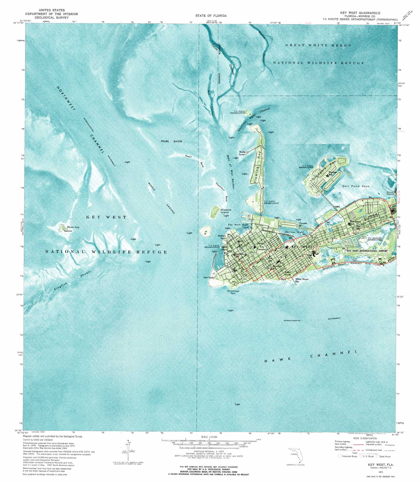
USGS Topo Quad 24081e7 - 1:24,000 scale
| Topo Map Name: | Key West |
| USGS Topo Quad ID: | 24081e7 |
| Print Size: | ca. 21 1/4" wide x 27" high |
| Southeast Coordinates: | 24.5° N latitude / 81.75° W longitude |
| Map Center Coordinates: | 24.5625° N latitude / 81.8125° W longitude |
| U.S. State: | FL |
| Filename: | P24081E7.jpg |
| Download Map JPG Image: | Key West topo map 1:24,000 scale |
| Map Type: | Orthophoto |
| Topo Series: | 7.5´ |
| Map Scale: | 1:24,000 |
| Source of Map Images: | United States Geological Survey (USGS) |
| Alternate Map Versions: |
Key West FL 1943 Download PDF Buy paper map Key West FL 1962, updated 1962 Download PDF Buy paper map Key West FL 1971, updated 1973 Download PDF Buy paper map Key West FL 1971, updated 1977 Download PDF Buy paper map Key West FL 2012 Download PDF Buy paper map Key West FL 2015 Download PDF Buy paper map |
1:24,000 Topo Quads surrounding Key West
Sawyer Key |
||||
Bay Keys |
Snipe Keys |
Sugarloaf Key |
||
Marquesas Keys East |
Cottrell Key |
Key West |
Boca Chica Key |
Saddlebunch Keys |
> Back to 24081e1 at 1:100,000 scale
> Back to 24080a1 at 1:250,000 scale
> Back to U.S. Topo Maps home
Key West topo map: Gazetteer
Key West: Airports
Chalks Key West Seaplane Base elevation 0m 0′Gulf of Mexico Seaplane Base elevation 0m 0′
Key West International Airport elevation 0m 0′
Key West: Bars
Calda Bank elevation 0m 0′Frankfort Bank elevation 0m 0′
Kingfish Shoals elevation 0m 0′
Middle Ground elevation 0m 0′
Pearl Bank elevation 0m 0′
Key West: Bays
Garrison Bight elevation 0m 0′Key West Bight elevation 0m 0′
Man of War Harbor elevation 0m 0′
Pearl Basin elevation 0m 0′
Key West: Beaches
Smathers Beach elevation 0m 0′Key West: Capes
Trumbo Point elevation 0m 0′Whitehead Spit elevation 1m 3′
Key West: Channels
Bluefish Channel elevation 0m 0′Calda Channel elevation 0m 0′
Fleming Key Cut elevation 0m 0′
Garrison Bight Channel elevation 0m 0′
Jack Channel elevation 0m 0′
Main Ship Channel elevation 0m 0′
Northwest Channel elevation 0m 0′
Key West: Islands
Dredgers Key elevation 2m 6′Fleming Key elevation 1m 3′
Key West elevation 1m 3′
Mule Key elevation 0m 0′
Salt Pond Keys elevation 0m 0′
Tank Island elevation 2m 6′
Wisteria Island elevation 2m 6′
Key West: Parks
Fort Zachary Taylor Historic State Park elevation 0m 0′Nancy Forrester's Secret Garden elevation 3m 9′
Key West: Populated Places
Key West elevation 1m 3′Stadium Mobile Home Park elevation 0m 0′
Key West: Post Offices
Key West Post Office elevation 2m 6′Key West digital topo map on disk
Buy this Key West topo map showing relief, roads, GPS coordinates and other geographical features, as a high-resolution digital map file on DVD: