Sugarloaf Key Topo Map Florida
To zoom in, hover over the map of Sugarloaf Key
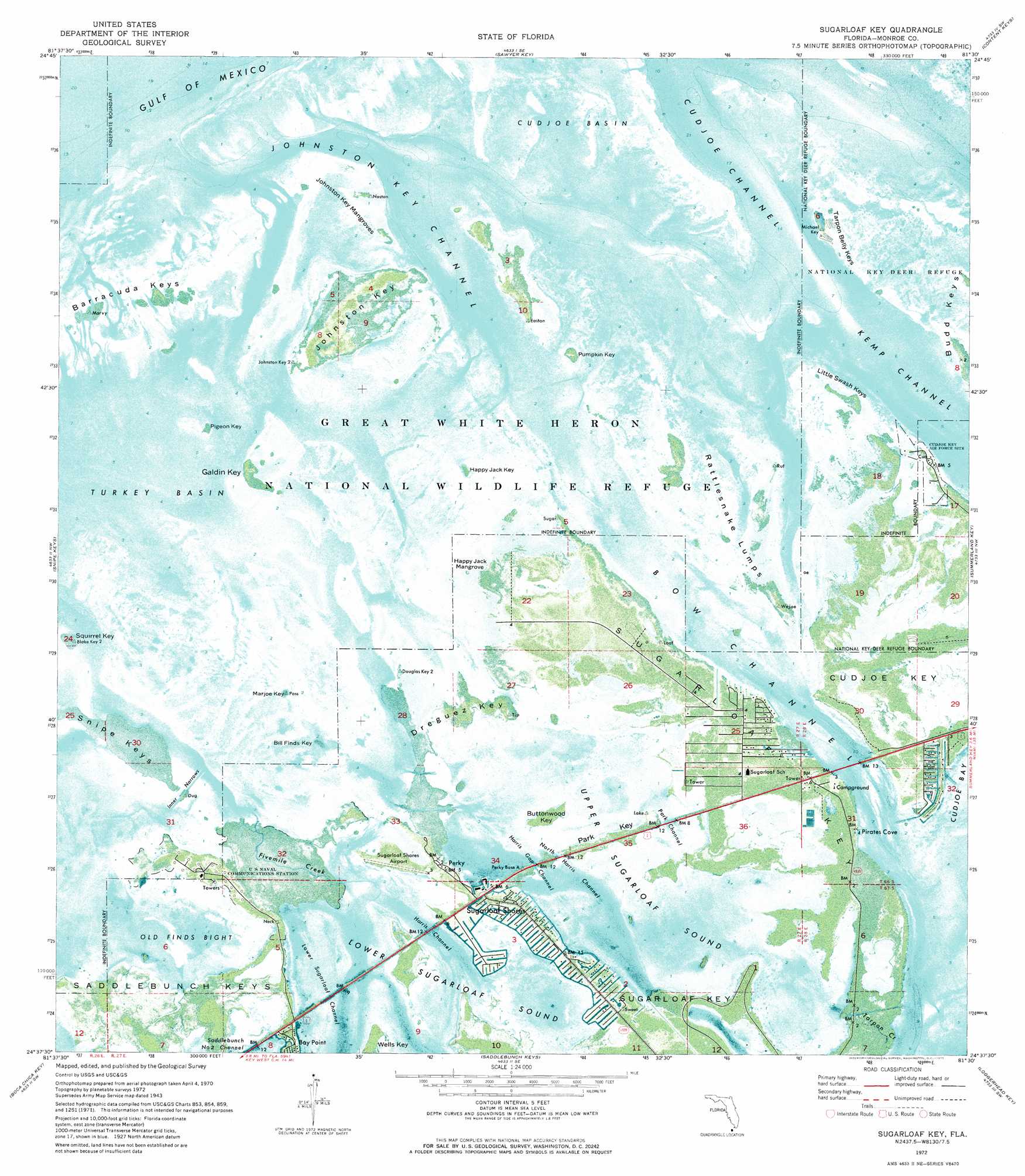
USGS Topo Quad 24081f5 - 1:24,000 scale
| Topo Map Name: | Sugarloaf Key |
| USGS Topo Quad ID: | 24081f5 |
| Print Size: | ca. 21 1/4" wide x 27" high |
| Southeast Coordinates: | 24.625° N latitude / 81.5° W longitude |
| Map Center Coordinates: | 24.6875° N latitude / 81.5625° W longitude |
| U.S. State: | FL |
| Filename: | P24081F5.jpg |
| Download Map JPG Image: | Sugarloaf Key topo map 1:24,000 scale |
| Map Type: | Orthophoto |
| Topo Series: | 7.5´ |
| Map Scale: | 1:24,000 |
| Source of Map Images: | United States Geological Survey (USGS) |
| Alternate Map Versions: |
Sugarloaf Key FL 1943 Download PDF Buy paper map Sugarloaf Key FL 1943, updated 1963 Download PDF Buy paper map Sugarloaf Key FL 1972, updated 1975 Download PDF Buy paper map Sugarloaf Key FL 2012 Download PDF Buy paper map Sugarloaf Key FL 2015 Download PDF Buy paper map |
1:24,000 Topo Quads surrounding Sugarloaf Key
Sawyer Key |
Content Keys |
Horseshoe Keys |
||
Bay Keys |
Snipe Keys |
Sugarloaf Key |
Summerland Key |
Big Pine Key |
Key West |
Boca Chica Key |
Saddlebunch Keys |
Key Lois |
> Back to 24081e1 at 1:100,000 scale
> Back to 24080a1 at 1:250,000 scale
> Back to U.S. Topo Maps home
Sugarloaf Key topo map: Gazetteer
Sugarloaf Key: Airports
Sugar Loaf Shores Airport elevation 0m 0′Sugarloaf Key: Bays
Cudjoe Basin elevation 0m 0′Lower Sugarloaf Sound elevation 0m 0′
Old Finds Bight elevation 0m 0′
Pirates Cove elevation 0m 0′
Turkey Basin elevation 0m 0′
Upper Sugarloaf Sound elevation 0m 0′
Sugarloaf Key: Channels
Bow Channel elevation 0m 0′Cudjoe Channel elevation 0m 0′
Harris Channel elevation 0m 0′
Harris Gap Channel elevation 0m 0′
Inner Narrows elevation 0m 0′
Johnston Key Channel elevation 0m 0′
Lower Sugarloaf Channel elevation 0m 0′
North Harris Channel elevation 0m 0′
Park Channel elevation 0m 0′
Saddlebunch Number Two Channel elevation 0m 0′
Sugarloaf Key: Guts
Fivemile Creek elevation 0m 0′Tarpon Creek elevation 0m 0′
Sugarloaf Key: Islands
Bill Finds Key elevation 0m 0′Budd Keys elevation 0m 0′
Buttonwood Key elevation 0m 0′
Dreguez Key elevation 0m 0′
Florida Keys elevation 0m 0′
Galdin Key elevation 0m 0′
Happy Jack Key elevation 0m 0′
Happy Jack Mangrove elevation 0m 0′
Johnston Key elevation 0m 0′
Johnston Key Mangroves elevation 0m 0′
Little Swash Keys elevation 0m 0′
Marjoe Key elevation 0m 0′
Park Key elevation 1m 3′
Pigeon Key elevation 0m 0′
Pumpkin Key elevation 0m 0′
Rattlesnake Lumps elevation 0m 0′
Squirrel Key elevation 0m 0′
Sugarloaf Key elevation 0m 0′
Tarpon Belly Keys elevation 0m 0′
Wells Key elevation 0m 0′
Sugarloaf Key: Parks
Great White Heron National Wildlife Refuge elevation 0m 0′Sugarloaf Key: Populated Places
Bay Point elevation 0m 0′Perky elevation 0m 0′
Pirates Cove elevation 0m 0′
Sugarloaf Shores elevation 1m 3′
Sugarloaf Key: Post Offices
Perky Post Office (historical) elevation 0m 0′Sugarloaf Key digital topo map on disk
Buy this Sugarloaf Key topo map showing relief, roads, GPS coordinates and other geographical features, as a high-resolution digital map file on DVD: