Key Biscayne Topo Map Florida
To zoom in, hover over the map of Key Biscayne
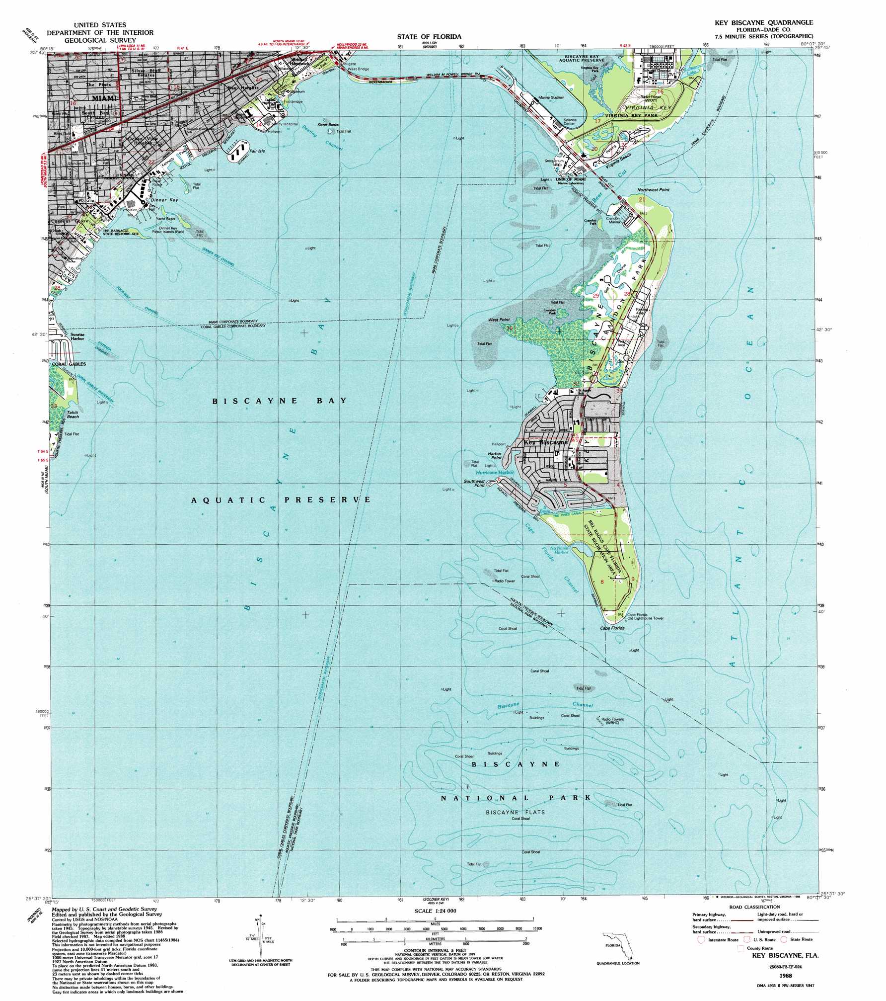
USGS Topo Quad 25080f2 - 1:24,000 scale
| Topo Map Name: | Key Biscayne |
| USGS Topo Quad ID: | 25080f2 |
| Print Size: | ca. 21 1/4" wide x 27" high |
| Southeast Coordinates: | 25.625° N latitude / 80.125° W longitude |
| Map Center Coordinates: | 25.6875° N latitude / 80.1875° W longitude |
| U.S. State: | FL |
| Filename: | O25080F2.jpg |
| Download Map JPG Image: | Key Biscayne topo map 1:24,000 scale |
| Map Type: | Topographic |
| Topo Series: | 7.5´ |
| Map Scale: | 1:24,000 |
| Source of Map Images: | United States Geological Survey (USGS) |
| Alternate Map Versions: |
Key Biscayne FL 1947, updated 1961 Download PDF Buy paper map Key Biscayne FL 1949, updated 1949 Download PDF Buy paper map Key Biscayne FL 1962, updated 1964 Download PDF Buy paper map Key Biscayne FL 1962, updated 1971 Download PDF Buy paper map Key Biscayne FL 1962, updated 1975 Download PDF Buy paper map Key Biscayne FL 1988, updated 1988 Download PDF Buy paper map Key Biscayne FL 1994, updated 1999 Download PDF Buy paper map Key Biscayne FL 2012 Download PDF Buy paper map Key Biscayne FL 2015 Download PDF Buy paper map |
1:24,000 Topo Quads surrounding Key Biscayne
Pennsuco |
Opa-Locka |
North Miami |
||
Hialeah Sw |
Hialeah |
Miami |
||
South Miami Nw |
South Miami |
Key Biscayne |
||
Goulds |
Perrine |
Soldier Key |
||
Homestead |
Arsenicker Keys |
Elliott Key |
> Back to 25080e1 at 1:100,000 scale
> Back to 25080a1 at 1:250,000 scale
> Back to U.S. Topo Maps home
Key Biscayne topo map: Gazetteer
Key Biscayne: Airports
Mercy Hospital Heliport elevation 1m 3′Key Biscayne: Bars
Biscayne Flats elevation 0m 0′Key Biscayne: Bays
South Basin elevation 0m 0′Key Biscayne: Beaches
Crandon Beach elevation 0m 0′Tahiti Beach elevation 0m 0′
Virginia Beach elevation 1m 3′
Key Biscayne: Bridges
Bay Bridge elevation 0m 0′Bear Cut Bridge elevation 0m 0′
West Bridge elevation 0m 0′
William M Powell Bridge elevation 0m 0′
Key Biscayne: Canals
The Pines Canal elevation 1m 3′Key Biscayne: Capes
Cape Florida elevation 1m 3′Harbor Point elevation 1m 3′
Northwest Point elevation 0m 0′
Southwest Point elevation 0m 0′
West Point elevation 0m 0′
Key Biscayne: Channels
Bear Cut elevation 0m 0′Biscayne Channel elevation 0m 0′
Cape Florida Channel elevation 0m 0′
Deering Channel elevation 0m 0′
Dinner Key Channel elevation 0m 0′
Entrada Channel elevation 0m 0′
Four-Way Channel elevation 0m 0′
Key Biscayne: Harbors
Cape Florida Anchorage elevation 0m 0′Crandon Marina elevation 0m 0′
Hurricane Harbor elevation 0m 0′
No Name Harbor elevation 0m 0′
Key Biscayne: Islands
Dinner Key elevation 1m 3′Grove Isle elevation 0m 0′
Key Biscayne elevation 1m 3′
Sister Banks elevation 0m 0′
Virginia Key elevation 5m 16′
Key Biscayne: Lakes
Duck Lake elevation 6m 19′Lamar Lake elevation 0m 0′
Key Biscayne: Parks
Alice C Wainwright Park elevation 4m 13′Bill Baggs Cape Florida State Park elevation 2m 6′
Biscayne National Park elevation 0m 0′
Blanche Park elevation 4m 13′
Coconut Grove Bay Front Park elevation 0m 0′
Coconut Grove Mini Park elevation 3m 9′
Crandon County Park elevation 1m 3′
Crandon Park elevation 1m 3′
Dinner Key Picnic Islands elevation 0m 0′
Douglas Mini Park elevation 4m 13′
Kennedy Park elevation 0m 0′
Lincoln Park elevation 4m 13′
Marine Stadium elevation 1m 3′
Miami Marine Stadium elevation 2m 6′
Monroe Park elevation 3m 9′
Myres Bayside Park elevation 1m 3′
Oak Avenue Park elevation 3m 9′
Peacock Park elevation 0m 0′
Steele Mini Park elevation 2m 6′
The Barnacle Historic State Park elevation 4m 13′
Virginia Beach County Park elevation 1m 3′
Virginia Key Park elevation 0m 0′
Vizcaya elevation 2m 6′
Vizcaya Gardens elevation 2m 6′
Vizcaya Park elevation 4m 13′
Wiscaya County Park elevation 3m 9′
Key Biscayne: Populated Places
Bay Heights elevation 4m 13′Key Biscayne elevation 1m 3′
Ocean View Heights elevation 4m 13′
Silver Bluff Estates elevation 3m 9′
South Bay Estates elevation 3m 9′
Sunrise Harbor elevation 0m 0′
The Pines elevation 3m 9′
Key Biscayne: Post Offices
Coconut Grove Post Office elevation 3m 9′Key Biscayne Post Office elevation 1m 3′
Key Biscayne digital topo map on disk
Buy this Key Biscayne topo map showing relief, roads, GPS coordinates and other geographical features, as a high-resolution digital map file on DVD: