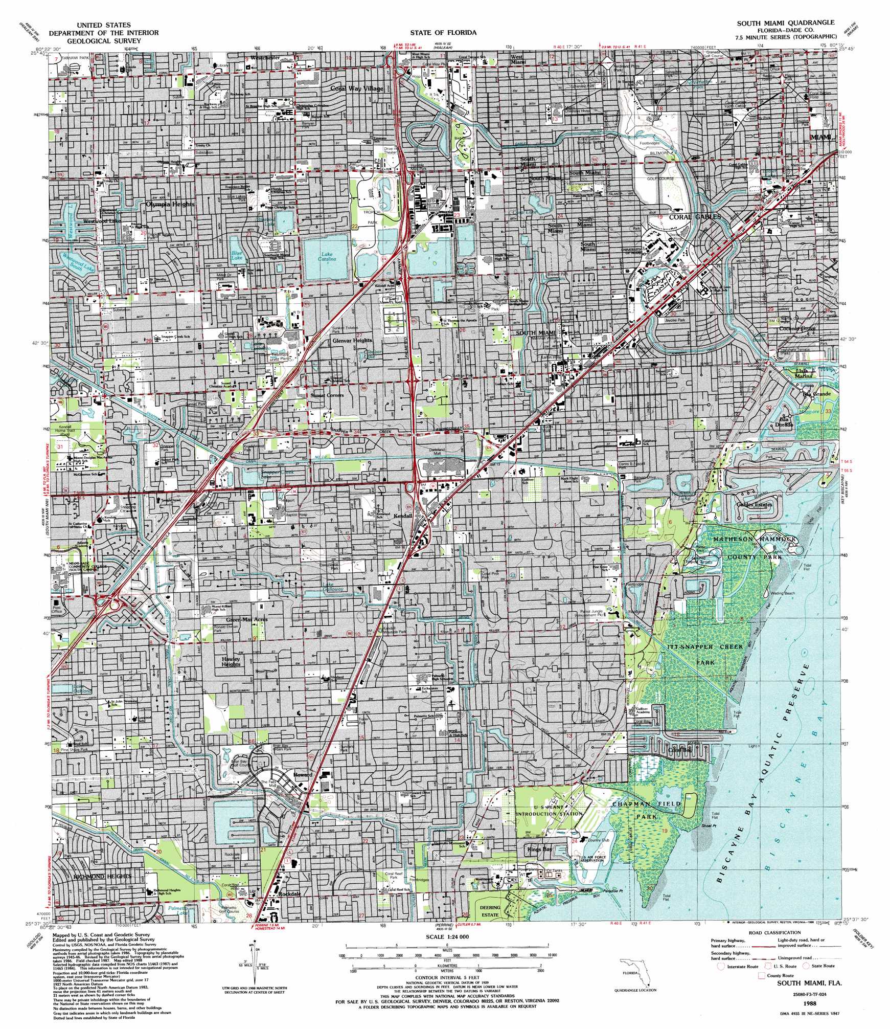
South Miami Topo Map Florida
To zoom in, hover over the map of South Miami
USGS Topo Quad 25080f3 - 1:24,000 scale
| Topo Map Name: | South Miami |
| USGS Topo Quad ID: | 25080f3 |
| Print Size: | ca. 21 1/4" wide x 27" high |
| Southeast Coordinates: | 25.625° N latitude / 80.25° W longitude |
| Map Center Coordinates: | 25.6875° N latitude / 80.3125° W longitude |
| U.S. State: | FL |
| Filename: | O25080F3.jpg |
| Download Map JPG Image: | South Miami topo map 1:24,000 scale |
| Map Type: | Topographic |
| Topo Series: | 7.5´ |
| Map Scale: | 1:24,000 |
| Source of Map Images: | United States Geological Survey (USGS) |
| Alternate Map Versions: |
South Miami FL 1950 Download PDF Buy paper map South Miami FL 1950 Download PDF Buy paper map South Miami FL 1956, updated 1957 Download PDF Buy paper map South Miami FL 1956, updated 1970 Download PDF Buy paper map South Miami FL 1988, updated 1988 Download PDF Buy paper map South Miami FL 1994, updated 2000 Download PDF Buy paper map South Miami FL 2012 Download PDF Buy paper map South Miami FL 2015 Download PDF Buy paper map |
1:24,000 Topo Quads surrounding South Miami
West Of Pennsuco |
Pennsuco |
Opa-Locka |
North Miami |
|
Coopertown |
Hialeah Sw |
Hialeah |
Miami |
|
South Of Coopertown |
South Miami Nw |
South Miami |
Key Biscayne |
|
Grossman Hammock |
Goulds |
Perrine |
Soldier Key |
|
Royal Palm Ranger Station |
Homestead |
Arsenicker Keys |
Elliott Key |
> Back to 25080e1 at 1:100,000 scale
> Back to 25080a1 at 1:250,000 scale
> Back to U.S. Topo Maps home
South Miami topo map: Gazetteer
South Miami: Airports
Baptist Hospital Heliport elevation 3m 9′Miami Childrens Hospital Heliport elevation 2m 6′
South Miami: Canals
Broad Canal elevation 1m 3′Coral Gables Canal elevation 1m 3′
Cutler Drain Canal Number C-100 elevation 1m 3′
Cutler Drain Canal Number C-100 A elevation 1m 3′
Cutler Drain Canal Number C-100 C elevation 1m 3′
Twin Lakes Canal elevation 1m 3′
South Miami: Capes
Paradise Point elevation 0m 0′Shoal Point elevation 0m 0′
South Miami: Channels
Coral Gables Waterway elevation 0m 0′Cutler Channel elevation 0m 0′
South Miami: Guts
Mahi Waterway elevation 1m 3′South Miami: Harbors
Yacht Basin elevation 1m 3′South Miami: Islands
Isla Dorada elevation 1m 3′Isla Grande elevation 0m 0′
South Miami: Lakes
Blue Lake elevation 1m 3′Bluebird Lake elevation 1m 3′
Coral Lake elevation 2m 6′
Glenvar Lake elevation 3m 9′
Hammock Lake elevation 1m 3′
Ixlater Lake elevation 1m 3′
Lago Maggiore elevation 0m 0′
Lago Minore elevation 0m 0′
Lago Monaco elevation 0m 0′
Lake Catalina elevation 0m 0′
Lake Galloway elevation 1m 3′
Lake Loladero elevation 2m 6′
Lake Oakland elevation 1m 3′
Palmetto Lake elevation 2m 6′
Snapper Creek Lake elevation 1m 3′
University Lake elevation 1m 3′
Westwood Lake elevation 1m 3′
Westwood Lake South elevation 1m 3′
South Miami: Parks
A D Barnes County Park elevation 1m 3′Banyan Drive Park elevation 1m 3′
Banyan Park elevation 2m 6′
Bird Drive Park elevation 2m 6′
Blue Lakes Park elevation 1m 3′
Brewer Park elevation 1m 3′
Briar Bay Urban Park elevation 3m 9′
Cartagena Plaza elevation 5m 16′
Chapman Field Park elevation 0m 0′
Continental Park elevation 3m 9′
Coral Bay Park elevation 1m 3′
Coral Gables Wayside Park elevation 2m 6′
Coral Pine Park elevation 2m 6′
Coral Reef Park elevation 1m 3′
Coral Way Park elevation 2m 6′
Dante B Fassell Park elevation 1m 3′
Deering Estate elevation 4m 13′
Douglas Park elevation 3m 9′
Fairchild Tropical Garden elevation 0m 0′
Ferdinand Plaza elevation 4m 13′
Fuchs Park elevation 2m 6′
Gifford Arboretum elevation 4m 13′
Grand Avenue Park elevation 3m 9′
Grapeland Heights Park elevation 4m 13′
Humble Mini Park elevation 3m 9′
I T T - Snapper Creek Park elevation 0m 0′
Ingraham Terrace elevation 1m 3′
Jaycee Park elevation 3m 9′
Kendale Park elevation 1m 3′
Kendall Home Tract elevation 3m 9′
Kendall Wayside Park elevation 0m 0′
Kendalwood Park elevation 3m 9′
K-Land Park elevation 1m 3′
Marshall Williams Park elevation 2m 6′
Matheson Hammock County Park elevation 0m 0′
Merrick Park elevation 3m 9′
Merrie Christmas Park elevation 2m 6′
Miller Drive Park elevation 2m 6′
Murray Park elevation 3m 9′
Palermo Park elevation 3m 9′
Parrot Jungle elevation 3m 9′
Pine Shore Park elevation 2m 6′
R Hardy Matheson County Preserve elevation 0m 0′
Riviera Park elevation 2m 6′
Rockdale Park elevation 3m 9′
Rockland Pineland County Preserve elevation 4m 13′
Rockway Park elevation 2m 6′
Ronald Ehman Park elevation 4m 13′
Salvadore Park elevation 4m 13′
Schenly Park elevation 4m 13′
Snapper Creek Park elevation 1m 3′
South Miami Recreation Area elevation 4m 13′
Suniland Park elevation 3m 9′
Sunkist Estates Park elevation 4m 13′
Sunrise Park elevation 1m 3′
Sunset Park elevation 3m 9′
Tamiami Park Stadium elevation 2m 6′
Trinity Pineland County Park elevation 3m 9′
Tropical Estates Park elevation 1m 3′
University Park elevation 4m 13′
Virrick Park elevation 3m 9′
Water Plant Park elevation 3m 9′
Young Park elevation 3m 9′
South Miami: Populated Places
Coconut Grove elevation 4m 13′Coral Gables elevation 3m 9′
Coral Terrace elevation 1m 3′
Coral Way Village elevation 2m 6′
Deering Bay elevation 0m 0′
Gables by the Sea elevation 1m 3′
Gables Estates elevation 1m 3′
Glenvar Heights elevation 4m 13′
Green-Mar Acres elevation 3m 9′
Hawley Heights elevation 3m 9′
Howard elevation 3m 9′
Kendall elevation 4m 13′
Kings Bay elevation 4m 13′
Ludlam elevation 2m 6′
Olympia Heights elevation 2m 6′
Pinecrest elevation 1m 3′
Pioneer Park elevation 2m 6′
Richmond Heights elevation 3m 9′
Rockdale elevation 4m 13′
South Miami elevation 3m 9′
Suniland elevation 3m 9′
Sunset elevation 2m 6′
Sunset Corners elevation 3m 9′
University Park elevation 1m 3′
Westwood Lake elevation 1m 3′
South Miami: Post Offices
Coral Gables Post Office elevation 3m 9′Ludlam Post Office elevation 2m 6′
South Miami Post Office elevation 3m 9′
South Miami: Reservoirs
Venetian Pool elevation 3m 9′South Miami digital topo map on disk
Buy this South Miami topo map showing relief, roads, GPS coordinates and other geographical features, as a high-resolution digital map file on DVD: