South Miami Nw Topo Map Florida
To zoom in, hover over the map of South Miami Nw
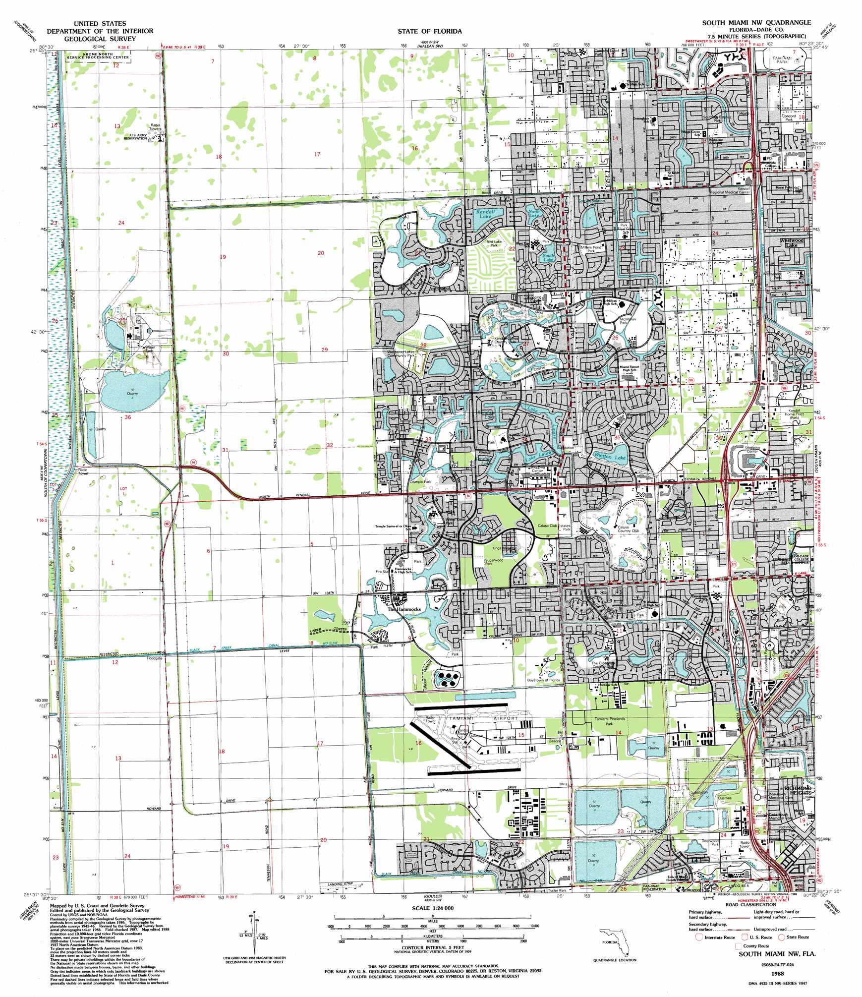
USGS Topo Quad 25080f4 - 1:24,000 scale
| Topo Map Name: | South Miami Nw |
| USGS Topo Quad ID: | 25080f4 |
| Print Size: | ca. 21 1/4" wide x 27" high |
| Southeast Coordinates: | 25.625° N latitude / 80.375° W longitude |
| Map Center Coordinates: | 25.6875° N latitude / 80.4375° W longitude |
| U.S. State: | FL |
| Filename: | O25080F4.jpg |
| Download Map JPG Image: | South Miami Nw topo map 1:24,000 scale |
| Map Type: | Topographic |
| Topo Series: | 7.5´ |
| Map Scale: | 1:24,000 |
| Source of Map Images: | United States Geological Survey (USGS) |
| Alternate Map Versions: |
South Miami NW FL 1949 Download PDF Buy paper map South Miami NW FL 1949 Download PDF Buy paper map South Miami NW FL 1955, updated 1957 Download PDF Buy paper map South Miami NW FL 1955, updated 1970 Download PDF Buy paper map South Miami NW FL 1994, updated 2000 Download PDF Buy paper map South Miami NW FL 2012 Download PDF Buy paper map South Miami NW FL 2015 Download PDF Buy paper map |
1:24,000 Topo Quads surrounding South Miami Nw
Custard Apple Hammock |
West Of Pennsuco |
Pennsuco |
Opa-Locka |
North Miami |
Long Island |
Coopertown |
Hialeah Sw |
Hialeah |
Miami |
Chekika Island |
South Of Coopertown |
South Miami Nw |
South Miami |
Key Biscayne |
Black Hammock |
Grossman Hammock |
Goulds |
Perrine |
Soldier Key |
Long Pine Key |
Royal Palm Ranger Station |
Homestead |
Arsenicker Keys |
Elliott Key |
> Back to 25080e1 at 1:100,000 scale
> Back to 25080a1 at 1:250,000 scale
> Back to U.S. Topo Maps home
South Miami Nw topo map: Gazetteer
South Miami Nw: Airports
Kendall District Station Heliport elevation 2m 6′Kendall-Tamiami Executive Airport elevation 2m 6′
Southwest Police Sub Station Heliport elevation 2m 6′
Tamiami Airport elevation 2m 6′
South Miami Nw: Canals
Bel Aire Canal Number C 1-N elevation 2m 6′Black Creek Canal NO C-1W elevation 1m 3′
Cutler Drain Canal Number C-100 elevation 1m 3′
Snapper Creek Canal Number C-100 elevation 3m 9′
South Miami Nw: Lakes
Kendale Lake elevation 1m 3′Kendale Lake elevation 1m 3′
Kendall Lake elevation 1m 3′
Lake Laura elevation 1m 3′
Lake Louise elevation 1m 3′
North Lake elevation 1m 3′
Republic Lake elevation 1m 3′
San Sebastian Lake elevation 0m 0′
South Lake elevation 1m 3′
Winston Lake elevation 1m 3′
South Miami Nw: Parks
Arvida Park elevation 3m 9′Bent Tree Park elevation 1m 3′
Big & Little George Hammocks County Park elevation 3m 9′
Bird Lake Park elevation 1m 3′
Boystown Pineland County Park elevation 2m 6′
Calusa Club Estates Park elevation 2m 6′
Concord Park elevation 1m 3′
Deerwood Park elevation 3m 9′
Devon Aire Park elevation 2m 6′
Kendale Lakes Park elevation 2m 6′
Kendall Indian Hammocks County Park elevation 2m 6′
Kings Meadow Park elevation 2m 6′
McMillian Park elevation 1m 3′
Millers Pond Park elevation 1m 3′
Nixon Smiley Pineland Preserve elevation 2m 6′
Olympic Park elevation 2m 6′
Richmond Park elevation 3m 9′
Royal Green Park elevation 2m 6′
Sabal Chase Park elevation 3m 9′
Southern Estates Park elevation 1m 3′
Sugarwood Park elevation 2m 6′
Tamiami Lakes Park elevation 1m 3′
Tamiami Park elevation 1m 3′
Tamiami Pinelands Park elevation 2m 6′
Water Oaks Park elevation 2m 6′
Westwind Lakes Community Park elevation 2m 6′
Westwood Park elevation 1m 3′
Winston Park elevation 1m 3′
South Miami Nw: Populated Places
Country Walk elevation 2m 6′Kendale Lakes elevation 1m 3′
Kendall Lakes elevation 1m 3′
Lindgren Acres elevation 2m 6′
The Crossings elevation 2m 6′
The Hammocks elevation 1m 3′
Three Lakes elevation 2m 6′
South Miami Nw: Post Offices
Country Lakes Post Office elevation 2m 6′Olympia Heights Post Office elevation 1m 3′
Sunset Post Office elevation 2m 6′
South Miami Nw digital topo map on disk
Buy this South Miami Nw topo map showing relief, roads, GPS coordinates and other geographical features, as a high-resolution digital map file on DVD: