Marco Island Topo Map Florida
To zoom in, hover over the map of Marco Island
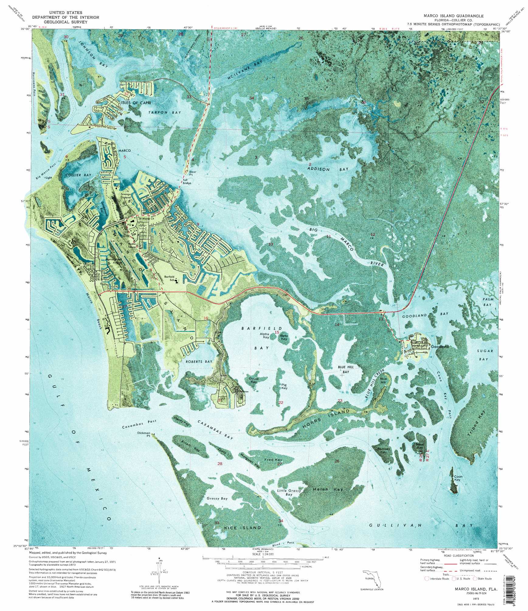
USGS Topo Quad 25081h6 - 1:24,000 scale
| Topo Map Name: | Marco Island |
| USGS Topo Quad ID: | 25081h6 |
| Print Size: | ca. 21 1/4" wide x 27" high |
| Southeast Coordinates: | 25.875° N latitude / 81.625° W longitude |
| Map Center Coordinates: | 25.9375° N latitude / 81.6875° W longitude |
| U.S. State: | FL |
| Filename: | P25081H6.jpg |
| Download Map JPG Image: | Marco Island topo map 1:24,000 scale |
| Map Type: | Orthophoto |
| Topo Series: | 7.5´ |
| Map Scale: | 1:24,000 |
| Source of Map Images: | United States Geological Survey (USGS) |
| Alternate Map Versions: |
Marco Island FL 1973, updated 1976 Download PDF Buy paper map Marco Island FL 1973, updated 1989 Download PDF Buy paper map Marco Island FL 1973, updated 1989 Download PDF Buy paper map Marco Island FL 1995, updated 1999 Download PDF Buy paper map Marco Island FL 2012 Download PDF Buy paper map Marco Island FL 2015 Download PDF Buy paper map |
1:24,000 Topo Quads surrounding Marco Island
Naples North |
Belle Meade Nw |
Belle Meade Ne |
Catherine Island |
|
Naples South |
Belle Meade |
Belle Meade Se |
Deep Lake Sw |
|
Marco Island |
Royal Palm Hammock |
Weavers Station |
||
Cape Romano |
Panther Key |
Everglades City |
||
> Back to 25081e1 at 1:100,000 scale
> Back to 25080a1 at 1:250,000 scale
> Back to U.S. Topo Maps home
Marco Island topo map: Gazetteer
Marco Island: Airports
Marco Island Airport elevation 0m 0′Marco Island: Bars
Clam Factory Shoal elevation 0m 0′Railroad Shoals elevation 0m 0′
Marco Island: Bays
Addison Bay elevation 0m 0′Barfield Bay elevation 0m 0′
Bear Point Cove elevation 0m 0′
Blue Hill Bay elevation 0m 0′
Caxambas Bay elevation 0m 0′
Collier Bay elevation 0m 0′
East Marco Bay elevation 0m 0′
Factory Bay elevation 0m 0′
Goodland Bay elevation 0m 0′
Grassy Bay elevation 0m 0′
Gullivan Bay elevation 0m 0′
Lighter Bay elevation 0m 0′
Little Grassy Bay elevation 0m 0′
Marco Bay elevation 0m 0′
McIlvane Bay elevation 0m 0′
One Island Bay elevation 0m 0′
Roberts Bay elevation 0m 0′
Sanctuary Sound elevation 0m 0′
Smokehouse Bay elevation 0m 0′
Sugar Bay elevation 0m 0′
Tarpon Bay elevation 0m 0′
The Muddies elevation 0m 0′
Three Island Cove elevation 0m 0′
Unknown Bay elevation 0m 0′
Upper Addison Bay elevation 0m 0′
Marco Island: Beaches
Marco Beach elevation 0m 0′Marco Island: Canals
Flotilla Passage elevation 1m 3′Marco Island: Capes
Bear Point elevation 0m 0′Bob Everett Point elevation 0m 0′
Dickmans Point elevation 0m 0′
Highland Point elevation 3m 9′
North Point elevation 0m 0′
Marco Island: Channels
Big Marco Pass elevation 0m 0′Blind Pass elevation 0m 0′
Cannon Channel elevation 0m 0′
Caxambas Pass elevation 0m 0′
Coon Key Pass elevation 0m 0′
Hells Gate elevation 0m 0′
Hurricane Pass elevation 0m 0′
Northwest Gate elevation 0m 0′
Snook Hole Channel elevation 0m 0′
Whiskey Creek elevation 0m 0′
Marco Island: Flats
Pink Curlew Flats elevation 0m 0′Sunfish Flat elevation 0m 0′
Marco Island: Guts
Big Marco River elevation 0m 0′Blue Hill Creek elevation 0m 0′
Capri Pass elevation 0m 0′
Smokehouse Creek elevation 0m 0′
Marco Island: Islands
Albert Island elevation 0m 0′Alpha Key elevation 0m 0′
Beta Key elevation 0m 0′
Big Key elevation 0m 0′
Charity Island elevation 0m 0′
Coconut Island elevation 0m 0′
Coon Key elevation 0m 0′
Currys Island elevation 0m 0′
David Key elevation 0m 0′
Dickmans Island elevation 0m 0′
Fred Key elevation 0m 0′
Helen Key elevation 0m 0′
Henry Key elevation 0m 0′
Horrs Island elevation 2m 6′
Johnson Island elevation 0m 0′
Kice Island elevation 0m 0′
Little Tide Key elevation 0m 0′
Marco Island elevation 1m 3′
Margaret Key elevation 0m 0′
Neal Key elevation 0m 0′
Pass Key elevation 0m 0′
Pig Key elevation 0m 0′
Railroad Islet elevation 0m 0′
Ramsey Key elevation 0m 0′
Rookery Island elevation 0m 0′
Sea Oat Island elevation 0m 0′
Stingaree Island elevation 0m 0′
Tripod Key elevation 0m 0′
Turtle Island elevation 0m 0′
Marco Island: Lakes
Johnson Snapper Hole elevation 0m 0′Marco Island: Parks
Cape Ramano - Ten Thousand Islands State Aquatic Preserve elevation 0m 0′Marco Island: Populated Places
Caxambas elevation 2m 6′Drop Anchor Mobile Home Park elevation 0m 0′
Goodland elevation 2m 6′
Isles of Capri elevation 0m 0′
Marco elevation 0m 0′
Marco Island: Streams
Angelwing Creek elevation 0m 0′Georgia Fruit Farm Creek elevation 0m 0′
South Marsh Creek elevation 0m 0′
Stanton Creek elevation 0m 0′
Turtle Creek elevation 0m 0′
Marco Island: Summits
Blue Hill elevation 0m 0′Marco Island digital topo map on disk
Buy this Marco Island topo map showing relief, roads, GPS coordinates and other geographical features, as a high-resolution digital map file on DVD: