Greenacres City Topo Map Florida
To zoom in, hover over the map of Greenacres City
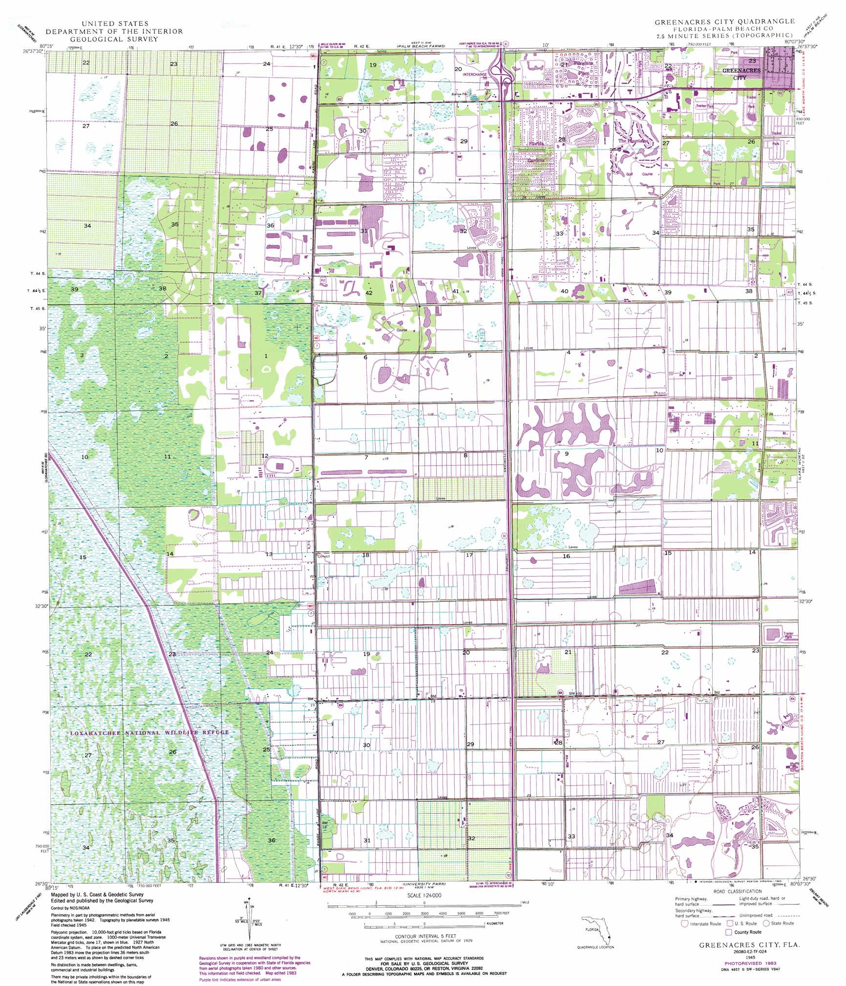
USGS Topo Quad 26080e2 - 1:24,000 scale
| Topo Map Name: | Greenacres City |
| USGS Topo Quad ID: | 26080e2 |
| Print Size: | ca. 21 1/4" wide x 27" high |
| Southeast Coordinates: | 26.5° N latitude / 80.125° W longitude |
| Map Center Coordinates: | 26.5625° N latitude / 80.1875° W longitude |
| U.S. State: | FL |
| Filename: | O26080E2.jpg |
| Download Map JPG Image: | Greenacres City topo map 1:24,000 scale |
| Map Type: | Topographic |
| Topo Series: | 7.5´ |
| Map Scale: | 1:24,000 |
| Source of Map Images: | United States Geological Survey (USGS) |
| Alternate Map Versions: |
Greenacres City FL 1945, updated 1961 Download PDF Buy paper map Greenacres City FL 1945, updated 1968 Download PDF Buy paper map Greenacres City FL 1945, updated 1976 Download PDF Buy paper map Greenacres City FL 1945, updated 1983 Download PDF Buy paper map Greenacres City FL 1950 Download PDF Buy paper map Greenacres City FL 2012 Download PDF Buy paper map Greenacres City FL 2015 Download PDF Buy paper map |
1:24,000 Topo Quads surrounding Greenacres City
Big Mound South |
West of Delta |
Delta |
Riviera Beach |
|
Loxahatchee Nw |
Loxahatchee |
Palm Beach Farms |
Palm Beach |
|
Loxahatchee Sw |
Loxahatchee Se |
Greenacres City |
Lake Worth |
|
Fort Lauderdale 2 Nw |
Fort Lauderdale 2 Ne |
University Park |
Delray Beach |
|
Fort Lauderdale 2 Sw |
Fort Lauderdale 2 Se |
West Dixie Bend |
Boca Raton |
> Back to 26080e1 at 1:100,000 scale
> Back to 26080a1 at 1:250,000 scale
> Back to U.S. Topo Maps home
Greenacres City topo map: Gazetteer
Greenacres City: Airports
Willis Gliderport elevation 5m 16′Greenacres City: Canals
L-40 Canal elevation 3m 9′Greenacres City: Crossings
Lake Worth Interchange elevation 5m 16′Greenacres City: Populated Places
Aberdeen elevation 5m 16′Briarwood Mobile Home Park elevation 5m 16′
Colonial Estates Mobile Home Park elevation 5m 16′
Florida Gardens elevation 5m 16′
Greenacres City elevation 5m 16′
Hometown Lake Worth Village elevation 5m 16′
Lake Worth Village Mobile Home Park elevation 5m 16′
Mas Verde Mobile Home Estates elevation 5m 16′
Palm Beach Plantation Mobile Home Park elevation 5m 16′
Poincianna Place elevation 5m 16′
Rainbow Lakes elevation 5m 16′
Sun Valley elevation 6m 19′
Greenacres City: Post Offices
Greenacres Post Office elevation 5m 16′Jog Road Post Office elevation 5m 16′
Greenacres City digital topo map on disk
Buy this Greenacres City topo map showing relief, roads, GPS coordinates and other geographical features, as a high-resolution digital map file on DVD: