Riviera Beach Topo Map Florida
To zoom in, hover over the map of Riviera Beach
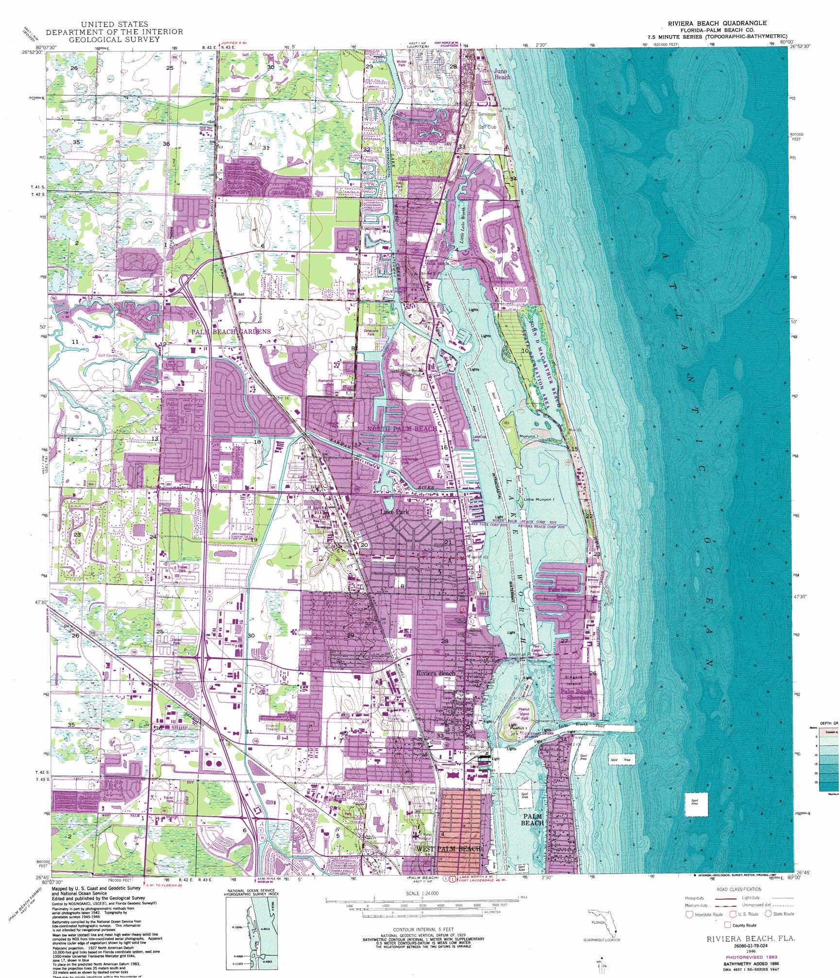
USGS Topo Quad 26080g1 - 1:24,000 scale
| Topo Map Name: | Riviera Beach |
| USGS Topo Quad ID: | 26080g1 |
| Print Size: | ca. 21 1/4" wide x 27" high |
| Southeast Coordinates: | 26.75° N latitude / 80° W longitude |
| Map Center Coordinates: | 26.8125° N latitude / 80.0625° W longitude |
| U.S. State: | FL |
| Filename: | O26080G1.jpg |
| Download Map JPG Image: | Riviera Beach topo map 1:24,000 scale |
| Map Type: | Topographic |
| Topo Series: | 7.5´ |
| Map Scale: | 1:24,000 |
| Source of Map Images: | United States Geological Survey (USGS) |
| Alternate Map Versions: |
Riviera Beach FL 1946, updated 1956 Download PDF Buy paper map Riviera Beach FL 1946, updated 1968 Download PDF Buy paper map Riviera Beach FL 1946, updated 1983 Download PDF Buy paper map Riviera Beach FL 1946, updated 1987 Download PDF Buy paper map Riviera Beach FL 1949 Download PDF Buy paper map Riviera Beach FL 2012 Download PDF Buy paper map Riviera Beach FL 2015 Download PDF Buy paper map |
1:24,000 Topo Quads surrounding Riviera Beach
Indiantown Se |
Gomez |
Hobe Sound |
||
West Palm Beach 2 Ne |
Rood |
Jupiter |
||
West of Delta |
Delta |
Riviera Beach |
||
Loxahatchee |
Palm Beach Farms |
Palm Beach |
||
Loxahatchee Se |
Greenacres City |
Lake Worth |
> Back to 26080e1 at 1:100,000 scale
> Back to 26080a1 at 1:250,000 scale
> Back to U.S. Topo Maps home
Riviera Beach topo map: Gazetteer
Riviera Beach: Airports
Brady Heliport elevation 2m 6′Braman Heliport elevation 0m 0′
Florida Power and Light-Juno Beach Heliport elevation 3m 9′
J and C MacArthur Foundation Heliport elevation 4m 13′
Palm Beach Gardens Medical Center Heliport elevation 3m 9′
Saint Marys Hospital Heliport elevation 6m 19′
WPEC Helistop elevation 5m 16′
Riviera Beach: Bridges
Parker Bridge elevation 2m 6′Riviera Beach Bridge elevation 0m 0′
Riviera Beach: Canals
Loxahatchee Canal elevation 4m 13′North Palm Beach Waterway elevation 0m 0′
Thompson elevation 3m 9′
Riviera Beach: Capes
Sherman Point elevation 0m 0′Riviera Beach: Channels
Entrance Channel elevation 0m 0′Lake Worth Inlet elevation 0m 0′
Lake Worth Inner Channel elevation 0m 0′
Riviera Beach: Crossings
Interchange 74 elevation 4m 13′Interchange 76 elevation 4m 13′
Interchange 77 elevation 4m 13′
Interchange 79A and 79B elevation 4m 13′
Riviera Beach: Harbors
Port of Palm Beach elevation 2m 6′Riviera Beach: Islands
Little Munyon Island elevation 0m 0′Munyon Island elevation 0m 0′
Peanut Island elevation 3m 9′
Singer Island elevation 1m 3′
Riviera Beach: Lakes
Lake Little Worth elevation 0m 0′Square Lake elevation 4m 13′
Riviera Beach: Parks
Alamanda Park elevation 2m 6′Delacorte Park elevation 0m 0′
John D MacArthur Beach State Park elevation 1m 3′
Juno Park elevation 5m 16′
Osborne Park elevation 2m 6′
Peanut Island Park elevation 1m 3′
Winter Park elevation 2m 6′
Riviera Beach: Populated Places
A Garden Walk Mobile Home Park elevation 4m 13′Akers Away Mobile Home Park elevation 4m 13′
Gramercy Park elevation 4m 13′
Hi Acres Park Mobile Home Park elevation 4m 13′
Hilltop Gardens Mobile Home Park elevation 3m 9′
Juno Isles elevation 1m 3′
Juno Ridge elevation 4m 13′
Lake Park elevation 4m 13′
Lehmans Court Mobile Home Park elevation 3m 9′
Mangonia Park elevation 5m 16′
Meadows Mobile Home Park elevation 1m 3′
Monet elevation 3m 9′
North Palm Beach elevation 3m 9′
Palm Beach Isles elevation 0m 0′
Palm Beach Shores elevation 3m 9′
Palm Lake Estates North Mobile Home Park elevation 4m 13′
Palm Lake Estates South elevation 4m 13′
Riviera Beach elevation 4m 13′
The Meadows Mobile Home Park elevation 2m 6′
Riviera Beach: Post Offices
Palm Beach Gardens Mall Post Office elevation 4m 13′Riviera Beach: Streams
Earman River elevation 0m 0′Riviera Beach digital topo map on disk
Buy this Riviera Beach topo map showing relief, roads, GPS coordinates and other geographical features, as a high-resolution digital map file on DVD: