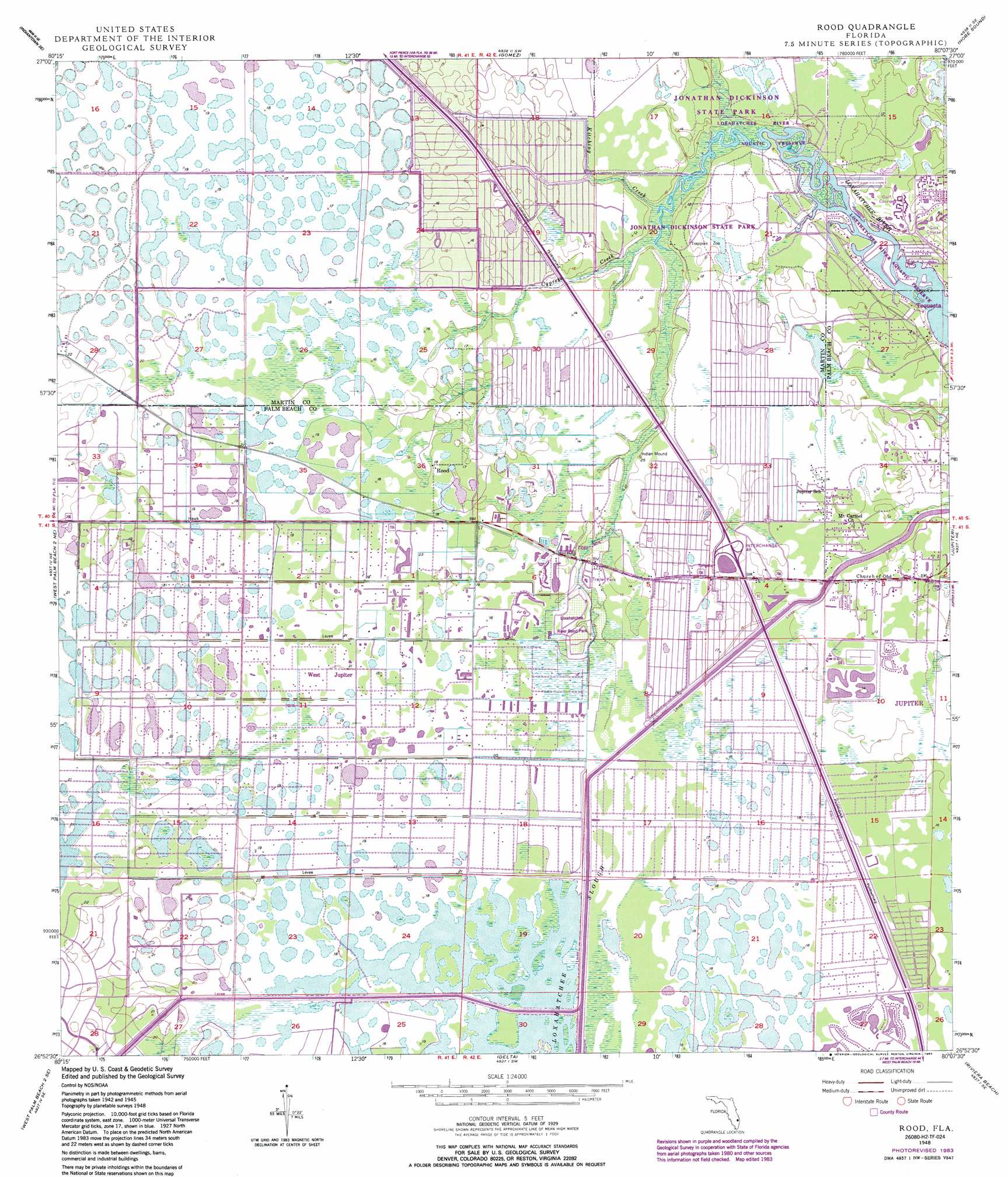
Rood Topo Map Florida
To zoom in, hover over the map of Rood
USGS Topo Quad 26080h2 - 1:24,000 scale
| Topo Map Name: | Rood |
| USGS Topo Quad ID: | 26080h2 |
| Print Size: | ca. 21 1/4" wide x 27" high |
| Southeast Coordinates: | 26.875° N latitude / 80.125° W longitude |
| Map Center Coordinates: | 26.9375° N latitude / 80.1875° W longitude |
| U.S. State: | FL |
| Filename: | O26080H2.jpg |
| Download Map JPG Image: | Rood topo map 1:24,000 scale |
| Map Type: | Topographic |
| Topo Series: | 7.5´ |
| Map Scale: | 1:24,000 |
| Source of Map Images: | United States Geological Survey (USGS) |
| Alternate Map Versions: |
Rood FL 1948, updated 1958 Download PDF Buy paper map Rood FL 1948, updated 1968 Download PDF Buy paper map Rood FL 1948, updated 1974 Download PDF Buy paper map Rood FL 1948, updated 1983 Download PDF Buy paper map Rood FL 1948, updated 1983 Download PDF Buy paper map Rood FL 1949 Download PDF Buy paper map Rood FL 2012 Download PDF Buy paper map Rood FL 2015 Download PDF Buy paper map |
1:24,000 Topo Quads surrounding Rood
Indian Town Nw |
Palm City |
Saint Lucie Inlet |
||
Indian Town |
Indiantown Se |
Gomez |
Hobe Sound |
|
West Palm Beach 2 Nw |
West Palm Beach 2 Ne |
Rood |
Jupiter |
|
Big Mound South |
West of Delta |
Delta |
Riviera Beach |
|
Loxahatchee Nw |
Loxahatchee |
Palm Beach Farms |
Palm Beach |
> Back to 26080e1 at 1:100,000 scale
> Back to 26080a1 at 1:250,000 scale
> Back to U.S. Topo Maps home
Rood topo map: Gazetteer
Rood: Airports
B R Ranch Airport elevation 6m 19′Flying H Heliport elevation 5m 16′
Tailwinds Airport elevation 5m 16′
Rood: Canals
Hungryland Slough Canal elevation 6m 19′Rood: Crossings
Interchange 48 elevation 4m 13′Interchange 83 elevation 5m 16′
Interchange 87 elevation 4m 13′
Rood: Parks
Loxahatchee River Aquatic Preserve elevation 0m 0′Loxahatchee River Bend Park elevation 4m 13′
Rood: Populated Places
Limestone Creek elevation 3m 9′North Palm Beach Heights elevation 5m 16′
Rood elevation 4m 13′
Tequesta elevation 3m 9′
West Jupiter elevation 4m 13′
West Jupiter Camping Resort elevation 5m 16′
Rood: Streams
Cypress Creek elevation 0m 0′Kitching Creek elevation 0m 0′
Rood digital topo map on disk
Buy this Rood topo map showing relief, roads, GPS coordinates and other geographical features, as a high-resolution digital map file on DVD: