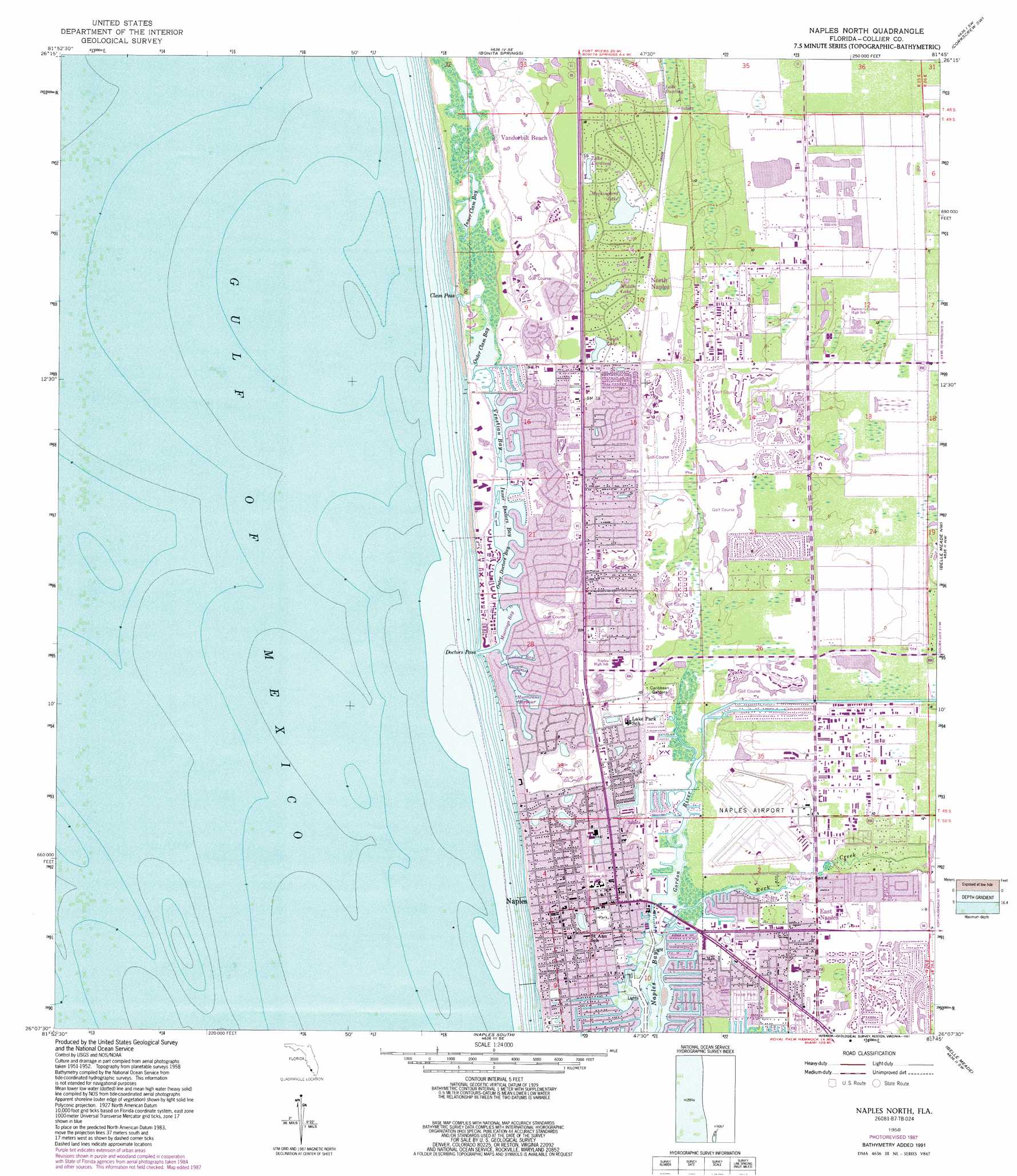
Naples North Topo Map Florida
To zoom in, hover over the map of Naples North
USGS Topo Quad 26081b7 - 1:24,000 scale
| Topo Map Name: | Naples North |
| USGS Topo Quad ID: | 26081b7 |
| Print Size: | ca. 21 1/4" wide x 27" high |
| Southeast Coordinates: | 26.125° N latitude / 81.75° W longitude |
| Map Center Coordinates: | 26.1875° N latitude / 81.8125° W longitude |
| U.S. State: | FL |
| Filename: | O26081B7.jpg |
| Download Map JPG Image: | Naples North topo map 1:24,000 scale |
| Map Type: | Topographic |
| Topo Series: | 7.5´ |
| Map Scale: | 1:24,000 |
| Source of Map Images: | United States Geological Survey (USGS) |
| Alternate Map Versions: |
Naples North FL 1958, updated 1959 Download PDF Buy paper map Naples North FL 1958, updated 1965 Download PDF Buy paper map Naples North FL 1958, updated 1973 Download PDF Buy paper map Naples North FL 1958, updated 1979 Download PDF Buy paper map Naples North FL 1958, updated 1988 Download PDF Buy paper map Naples North FL 1958, updated 1991 Download PDF Buy paper map Naples North FL 2012 Download PDF Buy paper map Naples North FL 2015 Download PDF Buy paper map |
1:24,000 Topo Quads surrounding Naples North
Sanibel |
Fort Myers Beach |
Estero |
Corkscrew Nw |
Corkscrew |
Bonita Springs |
Corkscrew Sw |
Corkscrew Se |
||
Naples North |
Belle Meade Nw |
Belle Meade Ne |
||
Naples South |
Belle Meade |
Belle Meade Se |
||
Marco Island |
Royal Palm Hammock |
> Back to 26081a1 at 1:100,000 scale
> Back to 26080a1 at 1:250,000 scale
> Back to U.S. Topo Maps home
Naples North topo map: Gazetteer
Naples North: Airports
Naples Hospital Heliport elevation 2m 6′Naples Municipal Airport elevation 1m 3′
Naples North: Bays
Crayton Cove elevation 0m 0′Hurricane Harbor elevation 0m 0′
Inner Clam Bay elevation 1m 3′
Inner Doctors Bay elevation 0m 0′
Moorings Bay elevation 0m 0′
Outer Clam Bay elevation 0m 0′
Outer Doctors Bay elevation 0m 0′
Venetian Bay elevation 0m 0′
Naples North: Channels
Clam Pass elevation 0m 0′Doctors Pass elevation 0m 0′
Naples North: Parks
Caribbean Gardens elevation 2m 6′Naples North: Populated Places
East Naples elevation 1m 3′Harmony Shores Mobile Home Port elevation 1m 3′
Naples elevation 1m 3′
North Naples elevation 4m 13′
Pelican Bay elevation 4m 13′
Pine Ridge elevation 3m 9′
The Moorings elevation 0m 0′
Naples North: Post Offices
Naples Post Office elevation 1m 3′Naples North: Streams
Gordon River elevation 0m 0′Rock Creek elevation 0m 0′
Naples North digital topo map on disk
Buy this Naples North topo map showing relief, roads, GPS coordinates and other geographical features, as a high-resolution digital map file on DVD: