Fort Myers Nw Topo Map Florida
To zoom in, hover over the map of Fort Myers Nw
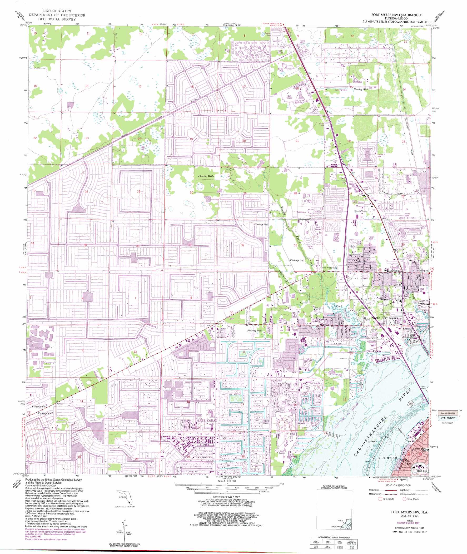
USGS Topo Quad 26081f8 - 1:24,000 scale
| Topo Map Name: | Fort Myers Nw |
| USGS Topo Quad ID: | 26081f8 |
| Print Size: | ca. 21 1/4" wide x 27" high |
| Southeast Coordinates: | 26.625° N latitude / 81.875° W longitude |
| Map Center Coordinates: | 26.6875° N latitude / 81.9375° W longitude |
| U.S. State: | FL |
| Filename: | O26081F8.jpg |
| Download Map JPG Image: | Fort Myers Nw topo map 1:24,000 scale |
| Map Type: | Topographic |
| Topo Series: | 7.5´ |
| Map Scale: | 1:24,000 |
| Source of Map Images: | United States Geological Survey (USGS) |
| Alternate Map Versions: |
Fort Myers NW FL 1958, updated 1959 Download PDF Buy paper map Fort Myers NW FL 1958, updated 1968 Download PDF Buy paper map Fort Myers NW FL 1958, updated 1973 Download PDF Buy paper map Fort Myers NW FL 1958, updated 1988 Download PDF Buy paper map Fort Myers NW FL 1958, updated 1991 Download PDF Buy paper map Fort Myers NW FL 2012 Download PDF Buy paper map Fort Myers NW FL 2015 Download PDF Buy paper map |
1:24,000 Topo Quads surrounding Fort Myers Nw
El Jobean |
Punta Gorda |
Cleveland |
Bermont |
Telegraph Swamp Nw |
Punta Gorda Sw |
Punta Gorda Se |
Gilchrist |
Tuckers Corner |
Telegraph Swamp |
Bokeelia |
Matlacha |
Fort Myers Nw |
Fort Myers |
Olga |
Captiva |
Pine Island Center |
Fort Myers Sw |
Fort Myers Se |
Alva Sw |
Wulfert |
Sanibel |
Fort Myers Beach |
Estero |
Corkscrew Nw |
> Back to 26081e1 at 1:100,000 scale
> Back to 26080a1 at 1:250,000 scale
> Back to U.S. Topo Maps home
Fort Myers Nw topo map: Gazetteer
Fort Myers Nw: Airports
Cape Coral Hospital Heliport elevation 3m 9′Pine Shadows Airpark elevation 5m 16′
Fort Myers Nw: Canals
Gator Slough Canal elevation 4m 13′Fort Myers Nw: Parks
Sun Splash Family Waterpark elevation 3m 9′Fort Myers Nw: Populated Places
Buccaneer Mobile Estates elevation 4m 13′Del Tura Country Club Mobile Home Park elevation 5m 16′
Evergreen Trailer Park elevation 1m 3′
Fox Mobile Home Park elevation 3m 9′
Holiday Acres Laynes 1 Mobile Home Park elevation 5m 16′
Horizon Mobile Home Village elevation 4m 13′
Island Vista Estates Mobile Home Park elevation 5m 16′
Jones Mobile Home Park elevation 4m 13′
Lake Fairways Country Club Mobile Home Park elevation 5m 16′
Lochmoor Waterway Estates elevation 1m 3′
Mere's Mobile Home Park elevation 2m 6′
North Fort Myers elevation 1m 3′
Palmona Park elevation 3m 9′
Robert's Trailer Park elevation 2m 6′
Serendipity Mobile Home Park elevation 4m 13′
Southern Villas Mobile Home Park elevation 4m 13′
Swan Lake Mobile Home Village elevation 4m 13′
Swifts Trailer Park elevation 3m 9′
Tara Woods Mobile Home Park elevation 5m 16′
The Heritage Mobile Home Park elevation 5m 16′
Tropical Palms Trailer Park elevation 2m 6′
Twin Pines Village Number 1 Mobile Home Park elevation 1m 3′
Twin Pines Village Number 2 Mobile Home Park elevation 1m 3′
W D Trailer Park elevation 5m 16′
Waterway Estates elevation 1m 3′
Windmill Village Mobile Home Park elevation 4m 13′
Fort Myers Nw: Post Offices
Cape Coral Central Post Office elevation 3m 9′North Fort Myers Post Office elevation 4m 13′
Fort Myers Nw: Streams
Hancock Creek elevation 0m 0′Manuel Branch elevation 0m 0′
Yellow Fever Creek elevation 1m 3′
Fort Myers Nw digital topo map on disk
Buy this Fort Myers Nw topo map showing relief, roads, GPS coordinates and other geographical features, as a high-resolution digital map file on DVD: