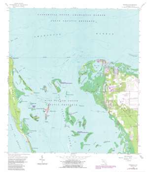
Bokeelia Topo Map Florida
To zoom in, hover over the map of Bokeelia
USGS Topo Quad 26082f2 - 1:24,000 scale
| Topo Map Name: | Bokeelia |
| USGS Topo Quad ID: | 26082f2 |
| Print Size: | ca. 21 1/4" wide x 27" high |
| Southeast Coordinates: | 26.625° N latitude / 82.125° W longitude |
| Map Center Coordinates: | 26.6875° N latitude / 82.1875° W longitude |
| U.S. State: | FL |
| Filename: | O26082F2.jpg |
| Download Map JPG Image: | Bokeelia topo map 1:24,000 scale |
| Map Type: | Topographic |
| Topo Series: | 7.5´ |
| Map Scale: | 1:24,000 |
| Source of Map Images: | United States Geological Survey (USGS) |
| Alternate Map Versions: |
Bokeelia FL 1958, updated 1959 Download PDF Buy paper map Bokeelia FL 1958, updated 1968 Download PDF Buy paper map Bokeelia FL 1958, updated 1972 Download PDF Buy paper map Bokeelia FL 1958, updated 1973 Download PDF Buy paper map Bokeelia FL 1958, updated 1987 Download PDF Buy paper map Bokeelia FL 1994, updated 1998 Download PDF Buy paper map Bokeelia FL 2012 Download PDF Buy paper map Bokeelia FL 2015 Download PDF Buy paper map |
1:24,000 Topo Quads surrounding Bokeelia
> Back to 26082e1 at 1:100,000 scale
> Back to 26082a1 at 1:250,000 scale
> Back to U.S. Topo Maps home
Bokeelia topo map: Gazetteer
Bokeelia: Airports
Bokeelia Helistop elevation 2m 6′Eagles Landing Airport elevation 2m 6′
Bokeelia: Bars
Jug Creek Point Shoal elevation 0m 0′Jug Creek Shoal elevation 0m 0′
Patricio Shoal elevation 0m 0′
Quarantine Rocks elevation 0m 0′
Useppa Oyster Bar elevation 0m 0′
Bokeelia: Bays
Back Bay elevation 0m 0′Little Bokeelia Bay elevation 0m 0′
Murdock Bayou elevation 0m 0′
Narrows Cove elevation 0m 0′
North Banks elevation 0m 0′
Old Tom Bayou elevation 0m 0′
Pelican Bay elevation 0m 0′
Primo Bay elevation 0m 0′
The Narrows elevation 0m 0′
Tom Bay elevation 0m 0′
Water Turkey Bayou elevation 0m 0′
Bokeelia: Capes
Platt Point elevation 0m 0′Primo Point elevation 0m 0′
Punta Blanca elevation 0m 0′
Bokeelia: Channels
Orange Pass elevation 0m 0′Pelican Pass elevation 0m 0′
Rocky Channel elevation 0m 0′
Shell Pass elevation 0m 0′
Wilson Cut elevation 0m 0′
Bokeelia: Guts
Big Jim Creek elevation 0m 0′Foster Bayou elevation 0m 0′
Jug Creek elevation 0m 0′
Bokeelia: Islands
Bird Key elevation 0m 0′Black Key elevation 0m 0′
Bokeelia Island elevation 0m 0′
Broken Islands elevation 0m 0′
Cabbage Key elevation 3m 9′
Camp Key elevation 0m 0′
Cat Key elevation 0m 0′
Cayo Costa elevation 1m 3′
Coon Key elevation 0m 0′
Cove Key elevation 0m 0′
Darling Key elevation 0m 0′
Josslyn Island elevation 0m 0′
Little Bokeelia Island elevation 1m 3′
Little Wood Key elevation 0m 0′
Middle Key elevation 0m 0′
Mondongo Island elevation 2m 6′
Mondongo Rocks elevation 0m 0′
Narrows Key elevation 0m 0′
Part Island elevation 0m 0′
Patricio Island elevation 1m 3′
Primo Island elevation 0m 0′
Punta Blanca Island elevation 0m 0′
Rat Key elevation 0m 0′
Useppa Island elevation 2m 6′
Whoopee Island elevation 0m 0′
Wood Key elevation 0m 0′
Bokeelia: Parks
Cayo Costa State Park elevation 1m 3′Pine Island National Wildlife Refuge elevation 0m 0′
Bokeelia: Populated Places
Bokeelia elevation 0m 0′Pineland elevation 0m 0′
Pink Citrus Mobile Home Park elevation 1m 3′
Bokeelia: Summits
Faulkner Mound elevation 3m 9′Howard Mound elevation 4m 13′
Bokeelia digital topo map on disk
Buy this Bokeelia topo map showing relief, roads, GPS coordinates and other geographical features, as a high-resolution digital map file on DVD:


