Punta Gorda Sw Topo Map Florida
To zoom in, hover over the map of Punta Gorda Sw
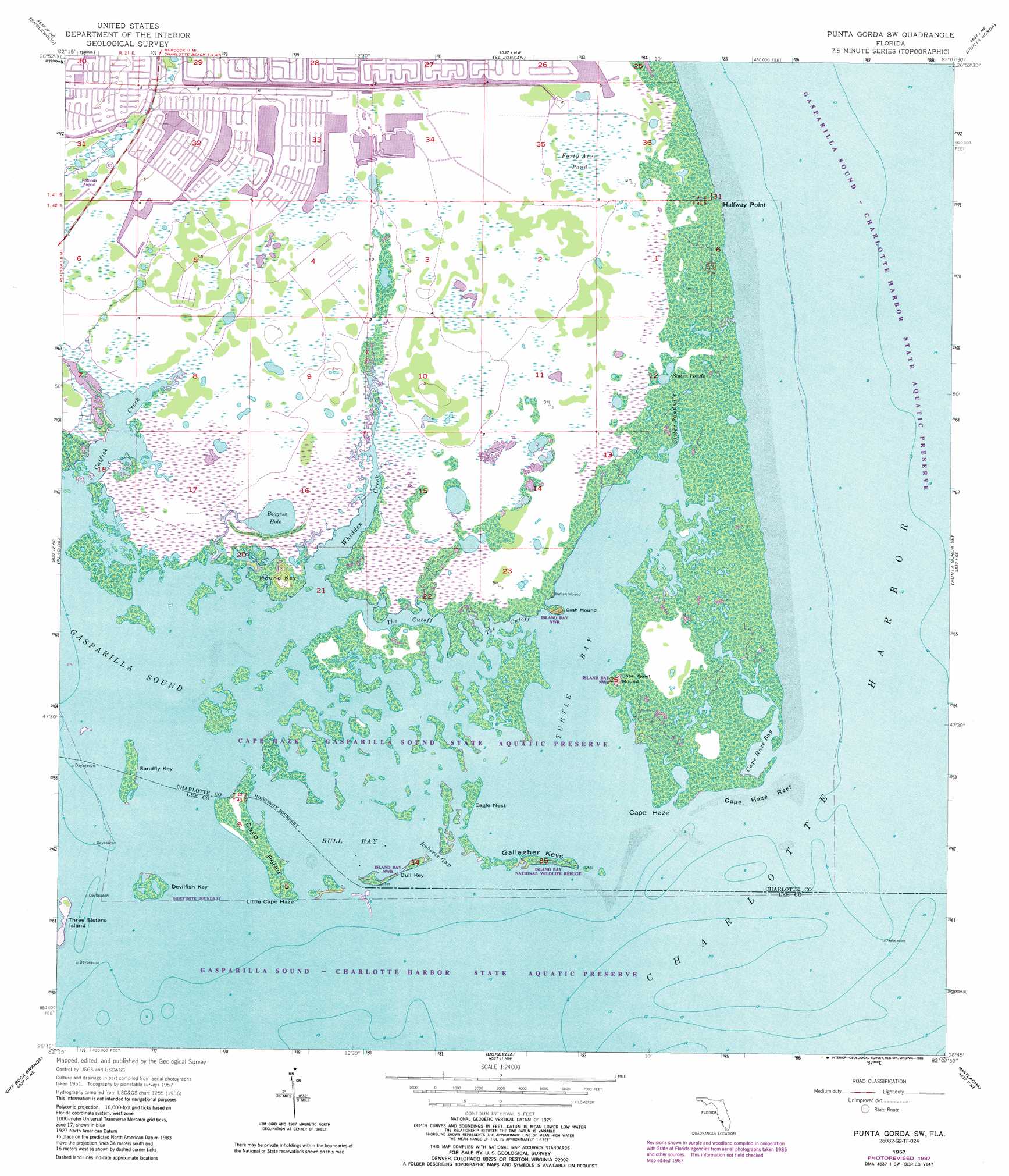
USGS Topo Quad 26082g2 - 1:24,000 scale
| Topo Map Name: | Punta Gorda Sw |
| USGS Topo Quad ID: | 26082g2 |
| Print Size: | ca. 21 1/4" wide x 27" high |
| Southeast Coordinates: | 26.75° N latitude / 82.125° W longitude |
| Map Center Coordinates: | 26.8125° N latitude / 82.1875° W longitude |
| U.S. State: | FL |
| Filename: | O26082G2.jpg |
| Download Map JPG Image: | Punta Gorda Sw topo map 1:24,000 scale |
| Map Type: | Topographic |
| Topo Series: | 7.5´ |
| Map Scale: | 1:24,000 |
| Source of Map Images: | United States Geological Survey (USGS) |
| Alternate Map Versions: |
Punta Gorda SW FL 1957, updated 1958 Download PDF Buy paper map Punta Gorda SW FL 1957, updated 1964 Download PDF Buy paper map Punta Gorda SW FL 1957, updated 1973 Download PDF Buy paper map Punta Gorda Sw FL 1957, updated 1988 Download PDF Buy paper map Punta Gorda SW FL 2012 Download PDF Buy paper map Punta Gorda SW FL 2015 Download PDF Buy paper map |
1:24,000 Topo Quads surrounding Punta Gorda Sw
Venice |
Myakka River |
Murdock |
Murdock Se |
Fort Ogden |
Englewood Nw |
Englewood |
El Jobean |
Punta Gorda |
Cleveland |
Placida |
Punta Gorda Sw |
Punta Gorda Se |
Gilchrist |
|
Port Boca Grande |
Bokeelia |
Matlacha |
Fort Myers Nw |
|
Captiva |
Pine Island Center |
Fort Myers Sw |
> Back to 26082e1 at 1:100,000 scale
> Back to 26082a1 at 1:250,000 scale
> Back to U.S. Topo Maps home
Punta Gorda Sw topo map: Gazetteer
Punta Gorda Sw: Bars
Cape Haze Reef elevation 0m 0′Punta Gorda Sw: Bays
Boggess Hole elevation 0m 0′Bull Bay elevation 0m 0′
Cape Haze Bay elevation 0m 0′
Charlotte Harbor elevation 0m 0′
Turtle Bay elevation 0m 0′
Punta Gorda Sw: Capes
Cape Haze elevation 0m 0′Halfway Point elevation 0m 0′
Little Cape Haze elevation 0m 0′
Punta Gorda Sw: Channels
The Cutoff elevation 0m 0′Punta Gorda Sw: Gaps
Roberts Gap elevation 0m 0′Punta Gorda Sw: Islands
Bull Key elevation 0m 0′Cayo Pelau elevation 0m 0′
Devilfish Key elevation 0m 0′
Eagle Nest elevation 0m 0′
Gallagher Keys elevation 0m 0′
Mound Key elevation 4m 13′
Sandfly Key elevation 0m 0′
Three Sisters Island elevation 0m 0′
Punta Gorda Sw: Lakes
Sister Pond elevation 0m 0′Punta Gorda Sw: Parks
Cape Haze-Gasparilla Sound Aquatic Preserve elevation 0m 0′Island Bay National Wildlife Refuge elevation 0m 0′
Punta Gorda Sw: Populated Places
Cayo Pelau elevation 0m 0′Punta Gorda Sw: Streams
Catfish Creek elevation 0m 0′Sister Pond Creek elevation 0m 0′
Whidden Creek elevation 0m 0′
Punta Gorda Sw: Summits
Cash Mound elevation 4m 13′John Quiet Mound elevation 2m 6′
Punta Gorda Sw: Swamps
Forty Acre Pond elevation 1m 3′Punta Gorda Sw digital topo map on disk
Buy this Punta Gorda Sw topo map showing relief, roads, GPS coordinates and other geographical features, as a high-resolution digital map file on DVD: