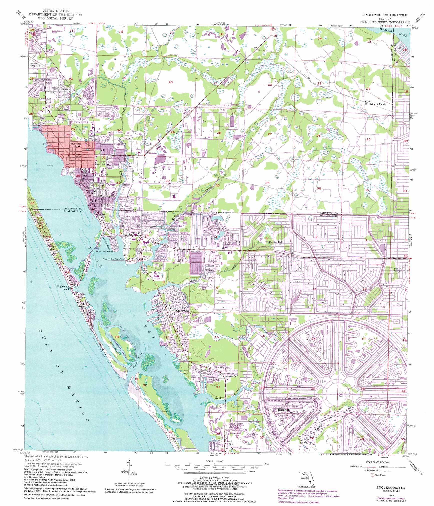
Englewood Topo Map Florida
To zoom in, hover over the map of Englewood
USGS Topo Quad 26082h3 - 1:24,000 scale
| Topo Map Name: | Englewood |
| USGS Topo Quad ID: | 26082h3 |
| Print Size: | ca. 21 1/4" wide x 27" high |
| Southeast Coordinates: | 26.875° N latitude / 82.25° W longitude |
| Map Center Coordinates: | 26.9375° N latitude / 82.3125° W longitude |
| U.S. State: | FL |
| Filename: | O26082H3.jpg |
| Download Map JPG Image: | Englewood topo map 1:24,000 scale |
| Map Type: | Topographic |
| Topo Series: | 7.5´ |
| Map Scale: | 1:24,000 |
| Source of Map Images: | United States Geological Survey (USGS) |
| Alternate Map Versions: |
Englewood FL 1956, updated 1958 Download PDF Buy paper map Englewood FL 1956, updated 1968 Download PDF Buy paper map Englewood FL 1956, updated 1973 Download PDF Buy paper map Englewood FL 1956, updated 1988 Download PDF Buy paper map Englewood NW FL 1957, updated 1988 Download PDF Buy paper map Englewood FL 2012 Download PDF Buy paper map Englewood FL 2015 Download PDF Buy paper map |
1:24,000 Topo Quads surrounding Englewood
Bird Keys |
Laurel |
Lower Myakka Lake |
Murdock Nw |
Murdock Ne |
Venice |
Myakka River |
Murdock |
Murdock Se |
|
Englewood Nw |
Englewood |
El Jobean |
Punta Gorda |
|
Placida |
Punta Gorda Sw |
Punta Gorda Se |
||
Port Boca Grande |
Bokeelia |
Matlacha |
> Back to 26082e1 at 1:100,000 scale
> Back to 26082a1 at 1:250,000 scale
> Back to U.S. Topo Maps home
Englewood topo map: Gazetteer
Englewood: Airports
Buchan Airport elevation 4m 13′Englewood: Bays
Knight Pass elevation 0m 0′Lemon Bay elevation 0m 0′
Redfish Cove elevation 0m 0′
Englewood: Beaches
Englewood Beach elevation 1m 3′Englewood: Bends
Deer Creek elevation 0m 0′Englewood: Bridges
Ainger Creek Bridge elevation 0m 0′Gottfried Creek Bridge elevation 1m 3′
Tom Adams Bridge elevation 0m 0′
Englewood: Canals
Bayou Canal elevation 1m 3′Boat Basin Canal elevation 1m 3′
Broadmoor Waterway elevation 2m 6′
Butterford Waterway elevation 3m 9′
Canal Number 1 elevation 1m 3′
Canal Number 2 elevation 1m 3′
Canal Number 3 elevation 0m 0′
Catfish Waterway elevation 1m 3′
De Charles Canal elevation 1m 3′
Eagle Nest Canal elevation 1m 3′
Gondolier Waterway elevation 2m 6′
Juno Canal elevation 1m 3′
Jupiter Canal elevation 1m 3′
Lake View Canal elevation 1m 3′
Long Meadow Creek elevation 1m 3′
March Waterway elevation 3m 9′
Mars Canal elevation 1m 3′
Memorial Waterway elevation 3m 9′
Minerva Canal elevation 1m 3′
Oakland Hills Creek elevation 2m 6′
Palm Canal elevation 0m 0′
Pebble Beach Creek elevation 2m 6′
Pine Valley Creek elevation 1m 3′
Pinehurst Creek elevation 2m 6′
Redfish Bayou elevation 1m 3′
Redfish Waterway elevation 2m 6′
Rotunda River elevation 3m 9′
San Victoria Canal elevation 1m 3′
Sea Mist Waterway elevation 3m 9′
Snook Bayou elevation 1m 3′
Trinitie Canal elevation 1m 3′
White Marsh Creek elevation 1m 3′
Englewood: Capes
Cedar Point elevation 0m 0′Point of Pines elevation 0m 0′
Englewood: Channels
Stump Pass elevation 0m 0′Englewood: Gaps
Peterson Cut elevation 0m 0′Englewood: Harbors
Yacht Basin elevation 0m 0′Englewood: Islands
Knight Island elevation 1m 3′Peterson Island elevation 0m 0′
Thorton Key elevation 0m 0′
Whidden Key elevation 0m 0′
Englewood: Lakes
Bass Lake elevation 2m 6′Lake Blueberry elevation 3m 9′
Lake Breeze Wood elevation 1m 3′
Lake Sturgeon elevation 3m 9′
Lake Sunapee elevation 3m 9′
Lake Van elevation 3m 9′
Palm Lake elevation 1m 3′
Troy Lake elevation 2m 6′
Englewood: Parks
Port Charlotte Beach State Park elevation 0m 0′Stump Pass Beach State Park elevation 0m 0′
Englewood: Populated Places
Deer Creek Mobile Home Park elevation 2m 6′Englewood elevation 3m 9′
Grove City elevation 3m 9′
Gulf to Bay Cooperative Mobile Home Park elevation 1m 3′
Manasota Key elevation 0m 0′
Mobile Gardens elevation 2m 6′
New Point Comfort elevation 1m 3′
Punta Gorda Beach elevation 1m 3′
Rotonda elevation 3m 9′
Sancassa elevation 3m 9′
Shaefer elevation 2m 6′
Englewood: Streams
Buck Creek elevation 0m 0′Goldfish Creek elevation 1m 3′
Gottfried Creek elevation 0m 0′
Lemon Creek elevation 0m 0′
Oyster Creek elevation 0m 0′
Rock Creek elevation 0m 0′
Englewood digital topo map on disk
Buy this Englewood topo map showing relief, roads, GPS coordinates and other geographical features, as a high-resolution digital map file on DVD: