Los Fresnos Topo Map Texas
To zoom in, hover over the map of Los Fresnos
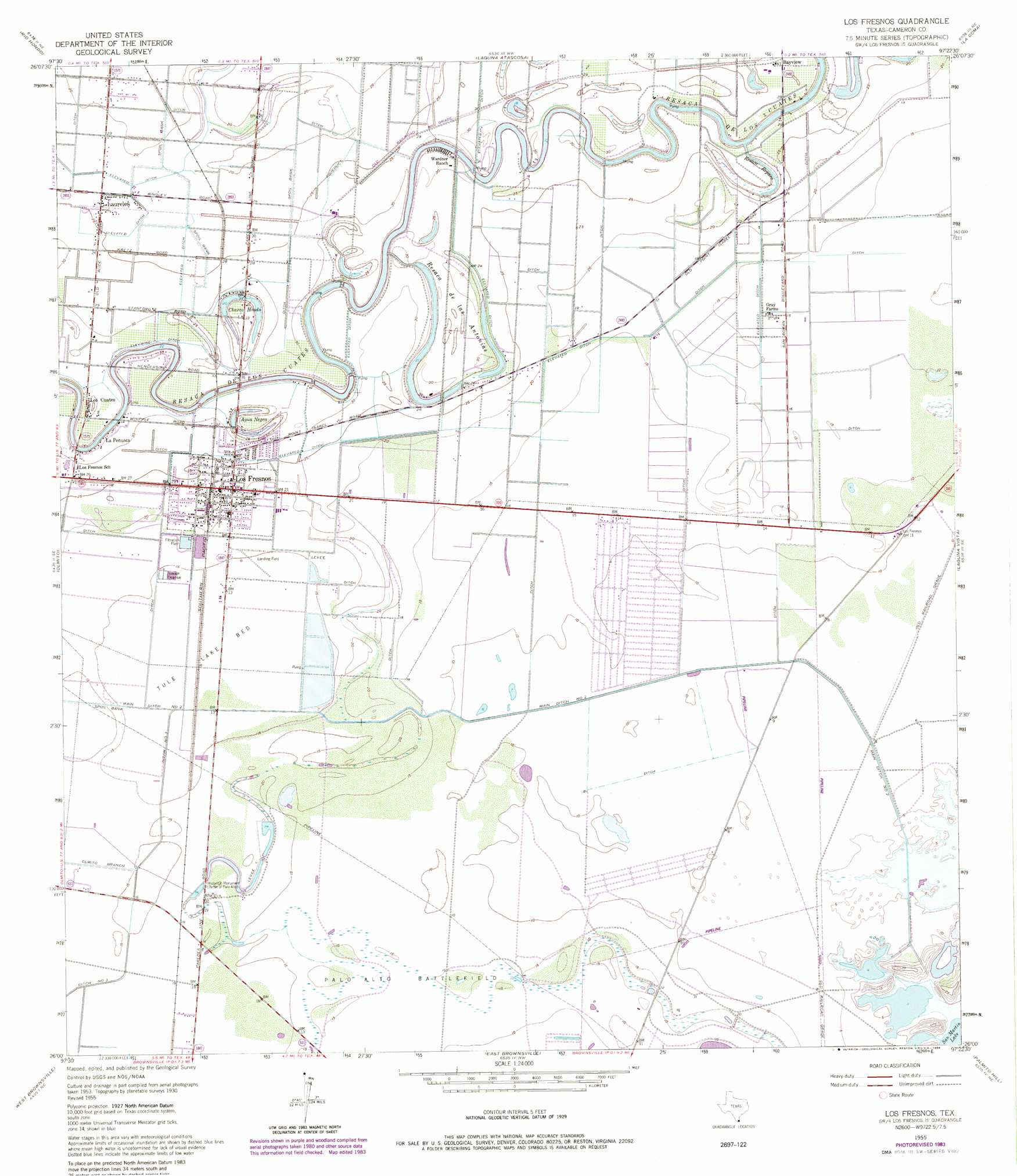
USGS Topo Quad 26097a4 - 1:24,000 scale
| Topo Map Name: | Los Fresnos |
| USGS Topo Quad ID: | 26097a4 |
| Print Size: | ca. 21 1/4" wide x 27" high |
| Southeast Coordinates: | 26° N latitude / 97.375° W longitude |
| Map Center Coordinates: | 26.0625° N latitude / 97.4375° W longitude |
| U.S. State: | TX |
| Filename: | o26097a4.jpg |
| Download Map JPG Image: | Los Fresnos topo map 1:24,000 scale |
| Map Type: | Topographic |
| Topo Series: | 7.5´ |
| Map Scale: | 1:24,000 |
| Source of Map Images: | United States Geological Survey (USGS) |
| Alternate Map Versions: |
Los Fresnos TX 1930 Download PDF Buy paper map Los Fresnos TX 1955, updated 1957 Download PDF Buy paper map Los Fresnos TX 1955, updated 1971 Download PDF Buy paper map Los Fresnos TX 1955, updated 1984 Download PDF Buy paper map Los Fresnos TX 2010 Download PDF Buy paper map Los Fresnos TX 2013 Download PDF Buy paper map Los Fresnos TX 2016 Download PDF Buy paper map |
1:24,000 Topo Quads surrounding Los Fresnos
Willamar Sw |
Paso Real |
La Leona |
Three Islands |
North Of Port Isabel Sw |
Harlingen |
Rio Hondo |
Laguna Atascosa |
La Coma |
Port Isabel Nw |
La Paloma |
Olmito |
Los Fresnos |
Laguna Vista |
Port Isabel |
West Brownsville |
East Brownsville |
Palmito Hill |
Mouth Of Rio Grande |
|
Southmost |
> Back to 26097a1 at 1:100,000 scale
> Back to 26096a1 at 1:250,000 scale
> Back to U.S. Topo Maps home
Los Fresnos topo map: Gazetteer
Los Fresnos: Airports
Drennan Farm Airport elevation 8m 26′Los Fresnos: Canals
Ditch Number Three elevation 5m 16′Main Ditch Number Two elevation 4m 13′
Los Fresnos: Dams
Dana-Tule Levee 1 Dam elevation 4m 13′Dana-Tule Levee 2 Dam elevation 5m 16′
Los Fresnos: Flats
Tule Lake Bed elevation 5m 16′Los Fresnos: Lakes
Agua Negra elevation 6m 19′Charco Hondo elevation 6m 19′
Resaca de las Antonias elevation 6m 19′
Resaca de los Cuates elevation 5m 16′
Resaca Reparo elevation 5m 16′
Los Fresnos: Parks
Historical Monument elevation 6m 19′Palo Alto Battlefield National Historic Site elevation 4m 13′
Los Fresnos: Populated Places
Chula Vista Colonia elevation 5m 16′Del Mar Heights elevation 3m 9′
Del Mar Heights Colonia elevation 3m 9′
La Peñusca elevation 10m 32′
Las Flores Colonia elevation 5m 16′
Laureles elevation 6m 19′
Los Cuates elevation 9m 29′
Los Fresnos elevation 7m 22′
Orason Acres Colonia elevation 6m 19′
Paredes Estates Colonia elevation 6m 19′
Shoemaker Acres Colonia elevation 5m 16′
Los Fresnos: Reservoirs
Dana-Tule Reservoir 1 elevation 4m 13′Dana-Tule Reservoir 2 elevation 5m 16′
Los Fresnos digital topo map on disk
Buy this Los Fresnos topo map showing relief, roads, GPS coordinates and other geographical features, as a high-resolution digital map file on DVD: