Three Islands Topo Map Texas
To zoom in, hover over the map of Three Islands
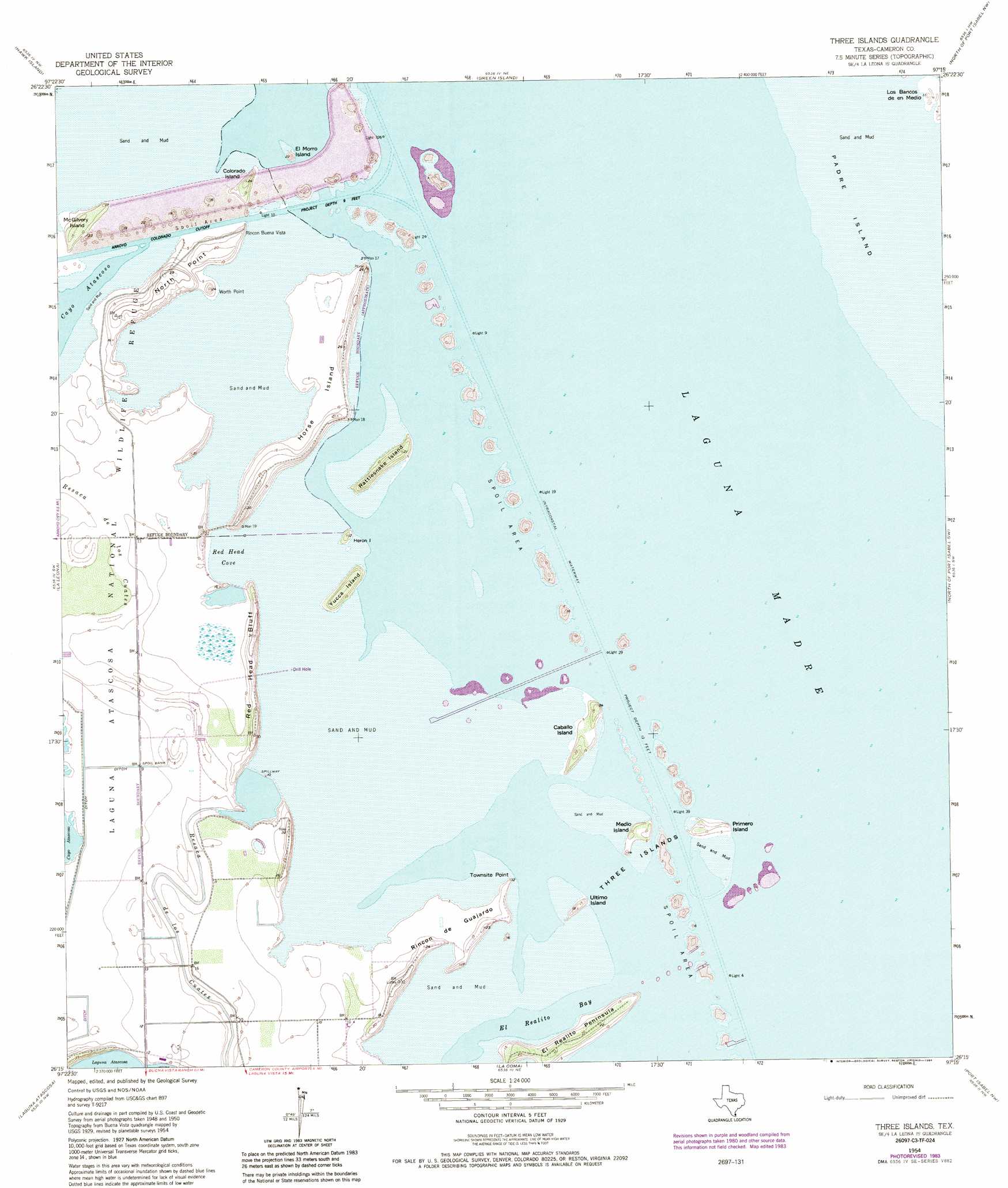
USGS Topo Quad 26097c3 - 1:24,000 scale
| Topo Map Name: | Three Islands |
| USGS Topo Quad ID: | 26097c3 |
| Print Size: | ca. 21 1/4" wide x 27" high |
| Southeast Coordinates: | 26.25° N latitude / 97.25° W longitude |
| Map Center Coordinates: | 26.3125° N latitude / 97.3125° W longitude |
| U.S. State: | TX |
| Filename: | o26097c3.jpg |
| Download Map JPG Image: | Three Islands topo map 1:24,000 scale |
| Map Type: | Topographic |
| Topo Series: | 7.5´ |
| Map Scale: | 1:24,000 |
| Source of Map Images: | United States Geological Survey (USGS) |
| Alternate Map Versions: |
Buena Vista TX 1929 Download PDF Buy paper map Three Islands TX 1954, updated 1957 Download PDF Buy paper map Three Islands TX 1954, updated 1971 Download PDF Buy paper map Three Islands TX 1954, updated 1984 Download PDF Buy paper map Three Islands TX 2010 Download PDF Buy paper map Three Islands TX 2013 Download PDF Buy paper map Three Islands TX 2016 Download PDF Buy paper map |
1:24,000 Topo Quads surrounding Three Islands
El Jardin |
Port Mansfield |
South Of Potrero Lopeno Se |
||
Willamar |
Hawk Island |
Green Island |
North Of Port Isabel Nw |
|
Paso Real |
La Leona |
Three Islands |
North Of Port Isabel Sw |
|
Rio Hondo |
Laguna Atascosa |
La Coma |
Port Isabel Nw |
|
Olmito |
Los Fresnos |
Laguna Vista |
Port Isabel |
> Back to 26097a1 at 1:100,000 scale
> Back to 26096a1 at 1:250,000 scale
> Back to U.S. Topo Maps home
Three Islands topo map: Gazetteer
Three Islands: Airports
Rancho Buena Vista Airport elevation 0m 0′Three Islands: Bays
El Realito Bay elevation 0m 0′Red Head Cove elevation 0m 0′
Three Islands: Capes
El Realito Peninsula elevation 6m 19′North Point elevation 8m 26′
Rincon Buena Vista elevation 3m 9′
Rincon de Guajardo elevation 3m 9′
Townsite Point elevation 0m 0′
Worth Point elevation 1m 3′
Three Islands: Cliffs
Red Head Bluff elevation 2m 6′Three Islands: Islands
Caballo Island elevation 2m 6′Colorado Island elevation 6m 19′
El Morro Island elevation 1m 3′
Heron Island elevation 2m 6′
Horse Island elevation 2m 6′
Los Bencos de en Medio elevation 1m 3′
McGilvery Island elevation 5m 16′
Medio Island elevation 3m 9′
Primero Island elevation 3m 9′
Rattlesnake Island elevation 6m 19′
Three Islands elevation 2m 6′
Ultimo Island elevation 4m 13′
Yucca Island elevation 6m 19′
Three Islands digital topo map on disk
Buy this Three Islands topo map showing relief, roads, GPS coordinates and other geographical features, as a high-resolution digital map file on DVD: