San Juan Se Topo Map Texas
To zoom in, hover over the map of San Juan Se
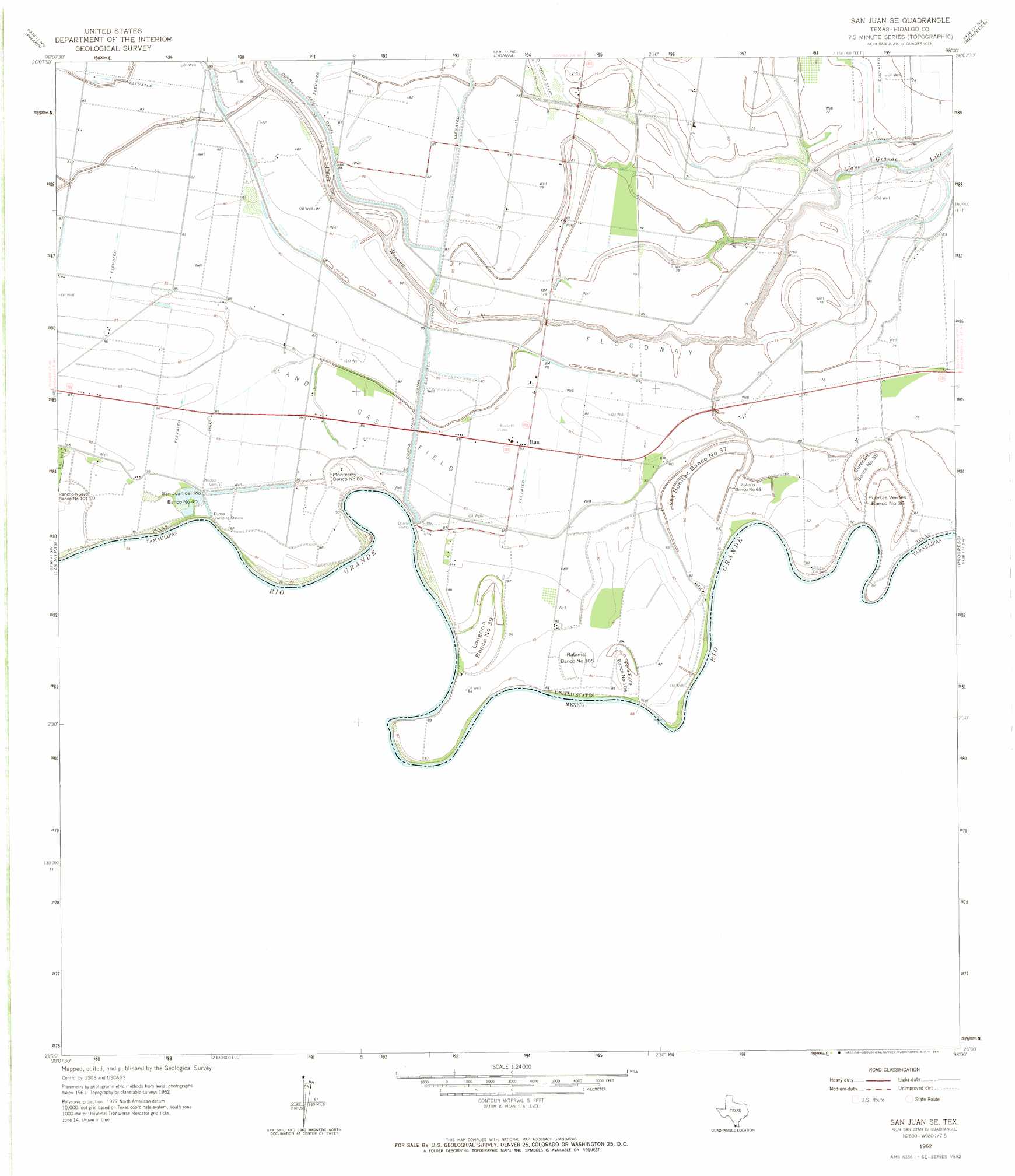
USGS Topo Quad 26098a1 - 1:24,000 scale
| Topo Map Name: | San Juan Se |
| USGS Topo Quad ID: | 26098a1 |
| Print Size: | ca. 21 1/4" wide x 27" high |
| Southeast Coordinates: | 26° N latitude / 98° W longitude |
| Map Center Coordinates: | 26.0625° N latitude / 98.0625° W longitude |
| U.S. State: | TX |
| Filename: | o26098a1.jpg |
| Download Map JPG Image: | San Juan Se topo map 1:24,000 scale |
| Map Type: | Topographic |
| Topo Series: | 7.5´ |
| Map Scale: | 1:24,000 |
| Source of Map Images: | United States Geological Survey (USGS) |
| Alternate Map Versions: |
San Juan SE TX 1962, updated 1965 Download PDF Buy paper map San Juan SE TX 2002, updated 2003 Download PDF Buy paper map San Juan SE TX 2010 Download PDF Buy paper map San Juan SE TX 2013 Download PDF Buy paper map San Juan SE TX 2016 Download PDF Buy paper map |
1:24,000 Topo Quads surrounding San Juan Se
Alton |
Edinburg |
La Blanca |
Edcouch |
Santa Rosa |
Mission |
Pharr |
Donna |
Mercedes |
La Feria |
Hidalgo |
Las Milpas |
San Juan Se |
Progreso |
Santa Maria |
> Back to 26098a1 at 1:100,000 scale
> Back to 26098a1 at 1:250,000 scale
> Back to U.S. Topo Maps home
San Juan Se topo map: Gazetteer
San Juan Se: Canals
Donna Main Canal elevation 24m 78′San Juan Se: Lakes
La Cruz Resaca elevation 25m 82′San Juan Se: Levees
Eurestes Banco Number 35 elevation 25m 82′La Bonitas Banco Number 37 elevation 23m 75′
Longoria Banco Number 39 elevation 26m 85′
Monterrey Banco Number 89 elevation 26m 85′
Peña Flora Banco Number 106 elevation 23m 75′
Puertas Verdes Banco Number 36 elevation 25m 82′
Rancho Nuevo Banco Number 101 elevation 26m 85′
Ratamal Banco Number 105 elevation 24m 78′
San Juan del Rio Banco Number 40 elevation 25m 82′
Zolezzi Banco Number 68 elevation 23m 75′
San Juan Se: Oilfields
Landa Gas Field elevation 25m 82′San Juan Se: Parks
Las Palomas Wildlife Management Area - Baird Unit elevation 23m 75′Las Palomas Wildlife Management Area - Champion Unit elevation 24m 78′
Las Palomas Wildlife Management Area - Chapote Unit elevation 22m 72′
Las Palomas Wildlife Management Area - McManus Unit elevation 24m 78′
Las Palomas Wildlife Management Area - Taormina Unit elevation 24m 78′
San Juan Se: Populated Places
9 North-East FM 493 Colonia elevation 24m 78′Runn elevation 25m 82′
Runn Colonia elevation 25m 82′
Vertress Colonia elevation 21m 68′
San Juan Se digital topo map on disk
Buy this San Juan Se topo map showing relief, roads, GPS coordinates and other geographical features, as a high-resolution digital map file on DVD: