Arroyo Miguel Topo Map Texas
To zoom in, hover over the map of Arroyo Miguel
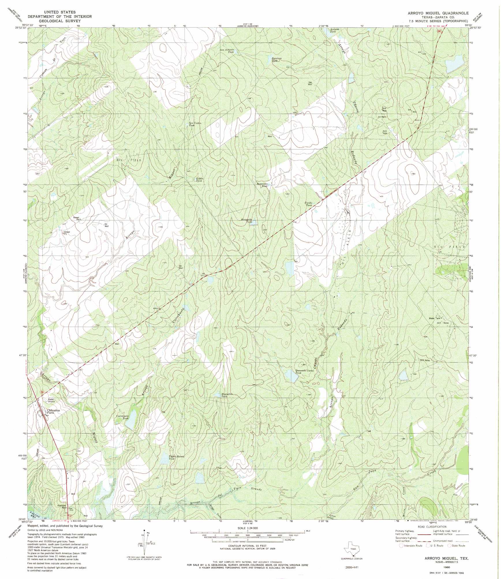
USGS Topo Quad 26099g1 - 1:24,000 scale
| Topo Map Name: | Arroyo Miguel |
| USGS Topo Quad ID: | 26099g1 |
| Print Size: | ca. 21 1/4" wide x 27" high |
| Southeast Coordinates: | 26.75° N latitude / 99° W longitude |
| Map Center Coordinates: | 26.8125° N latitude / 99.0625° W longitude |
| U.S. State: | TX |
| Filename: | o26099g1.jpg |
| Download Map JPG Image: | Arroyo Miguel topo map 1:24,000 scale |
| Map Type: | Topographic |
| Topo Series: | 7.5´ |
| Map Scale: | 1:24,000 |
| Source of Map Images: | United States Geological Survey (USGS) |
| Alternate Map Versions: |
Arroyo Miguel TX 1980, updated 1980 Download PDF Buy paper map Arroyo Miguel TX 2010 Download PDF Buy paper map Arroyo Miguel TX 2012 Download PDF Buy paper map Arroyo Miguel TX 2016 Download PDF Buy paper map |
1:24,000 Topo Quads surrounding Arroyo Miguel
Arroyo Burro |
Mogotes Hill |
Escobas |
Randado |
San Pablo Ranch |
Zapata |
Arroyo Veleno |
Arroyo Huisache |
Guerra |
San Antonio Viejo |
Zapata Se |
Arroyo Clareno |
Arroyo Miguel |
Cuevitas Sw |
Cuevitas |
Beckwith Arm |
Lopeno |
Las Escobas Ranch |
Viboras |
|
Falcon Village |
Salineno |
El Chapote Creek |
El Sauz |
> Back to 26099e1 at 1:100,000 scale
> Back to 26098a1 at 1:250,000 scale
> Back to U.S. Topo Maps home
Arroyo Miguel topo map: Gazetteer
Arroyo Miguel: Dams
Juan G Benavides Lake Dam elevation 104m 341′Lopez Lake Dam elevation 131m 429′
Quemada Corral Tank Dam elevation 108m 354′
Arroyo Miguel: Populated Places
Morales - Sanchez Colonia elevation 118m 387′Arroyo Miguel: Reservoirs
Arenosa Tank elevation 133m 436′Benevides Tank elevation 136m 446′
Correhuella Tank elevation 103m 337′
Esado Tank elevation 140m 459′
Juan G Benavides Lake elevation 104m 341′
Lopez Lake elevation 131m 429′
Maquelles Tank elevation 113m 370′
Margarita Tank elevation 134m 439′
Quemada Corral Tank elevation 110m 360′
San Antonio Tank elevation 144m 472′
San Ysidro Tank elevation 147m 482′
Tierra Blanca Tank elevation 104m 341′
Torido Tank elevation 123m 403′
Zacatoso Tank elevation 138m 452′
Arroyo Miguel: Springs
Charco Redondo Spring elevation 110m 360′Arroyo Miguel: Streams
Mexia Creek elevation 104m 341′San Juan Creek elevation 98m 321′
Arroyo Miguel: Valleys
Arroyo Charco Redondo elevation 98m 321′Arroyo Correhuella elevation 98m 321′
Arroyo Penas elevation 94m 308′
Arroyo Salado elevation 101m 331′
Arroyo Miguel digital topo map on disk
Buy this Arroyo Miguel topo map showing relief, roads, GPS coordinates and other geographical features, as a high-resolution digital map file on DVD: