Arroyo Huisache Topo Map Texas
To zoom in, hover over the map of Arroyo Huisache
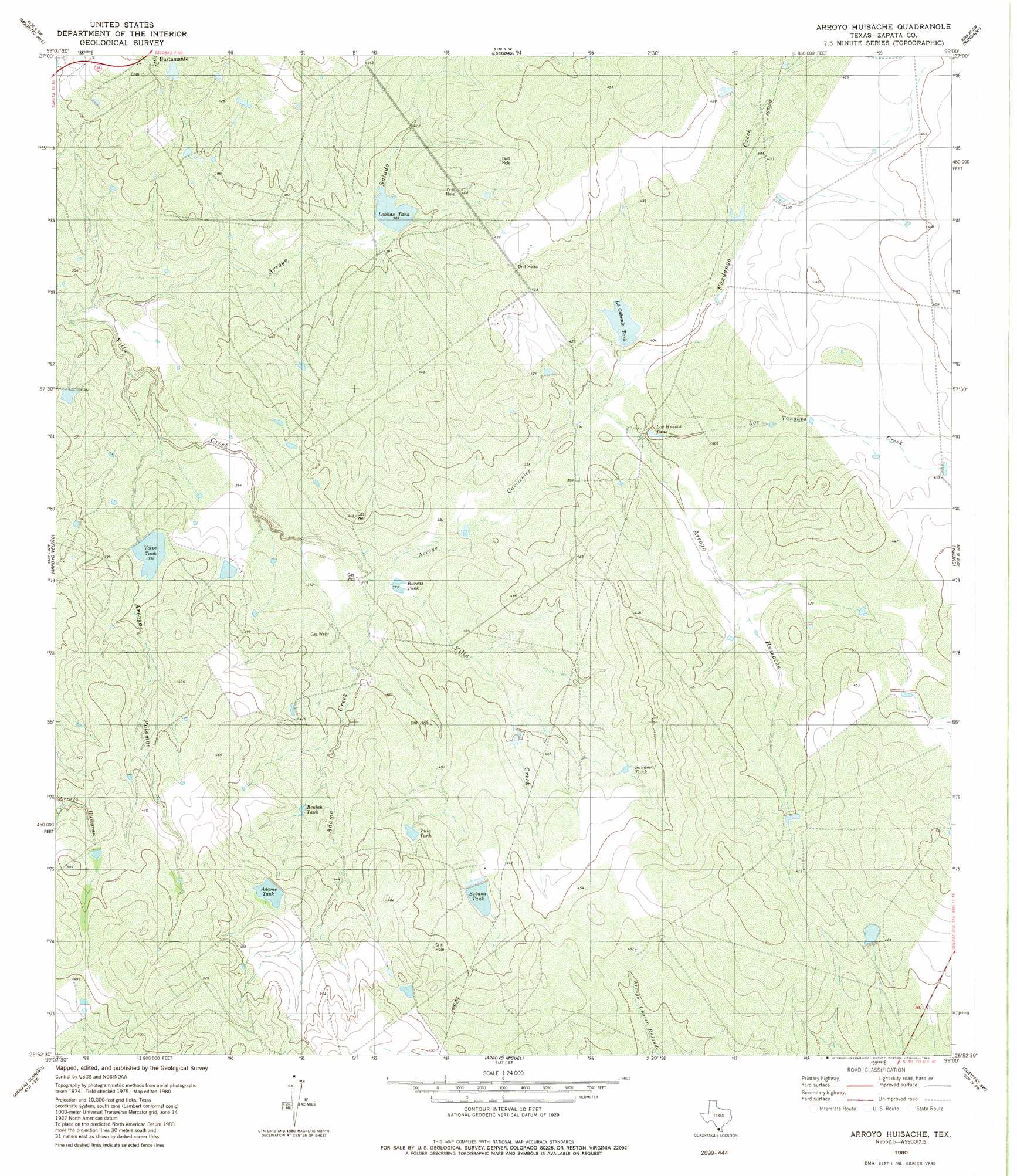
USGS Topo Quad 26099h1 - 1:24,000 scale
| Topo Map Name: | Arroyo Huisache |
| USGS Topo Quad ID: | 26099h1 |
| Print Size: | ca. 21 1/4" wide x 27" high |
| Southeast Coordinates: | 26.875° N latitude / 99° W longitude |
| Map Center Coordinates: | 26.9375° N latitude / 99.0625° W longitude |
| U.S. State: | TX |
| Filename: | o26099h1.jpg |
| Download Map JPG Image: | Arroyo Huisache topo map 1:24,000 scale |
| Map Type: | Topographic |
| Topo Series: | 7.5´ |
| Map Scale: | 1:24,000 |
| Source of Map Images: | United States Geological Survey (USGS) |
| Alternate Map Versions: |
Arroyo Huisache TX 1980, updated 1980 Download PDF Buy paper map Arroyo Huisache TX 2010 Download PDF Buy paper map Arroyo Huisache TX 2012 Download PDF Buy paper map Arroyo Huisache TX 2016 Download PDF Buy paper map |
1:24,000 Topo Quads surrounding Arroyo Huisache
Arroyo Salado East |
Las Ovejas Creek |
Chargos Creek |
Thompsonville |
Armstrong Ranch |
Arroyo Burro |
Mogotes Hill |
Escobas |
Randado |
San Pablo Ranch |
Zapata |
Arroyo Veleno |
Arroyo Huisache |
Guerra |
San Antonio Viejo |
Zapata Se |
Arroyo Clareno |
Arroyo Miguel |
Cuevitas Sw |
Cuevitas |
Beckwith Arm |
Lopeno |
Las Escobas Ranch |
Viboras |
> Back to 26099e1 at 1:100,000 scale
> Back to 26098a1 at 1:250,000 scale
> Back to U.S. Topo Maps home
Arroyo Huisache topo map: Gazetteer
Arroyo Huisache: Dams
Adame Tank Dam elevation 142m 465′Jones and Flores Lake Dam elevation 115m 377′
La Cabrada Tank Dam elevation 122m 400′
Vidaurri Lake Dam elevation 118m 387′
Volpe Tank Dam elevation 116m 380′
Arroyo Huisache: Reservoirs
Adame Tank elevation 141m 462′Beulah Tank elevation 128m 419′
Burras Tank elevation 114m 374′
Cuatus Tank elevation 148m 485′
Jones and Flores Lake elevation 115m 377′
La Cabrada Tank elevation 124m 406′
Lobitas Tank elevation 118m 387′
Los Huesos Tank elevation 122m 400′
Sabana Tank elevation 129m 423′
Sandoval Tank elevation 130m 426′
Vidaurri Lake elevation 118m 387′
Villa Tank elevation 132m 433′
Volpe Tank elevation 119m 390′
Arroyo Huisache: Streams
Adame Creek elevation 114m 374′Fandango Creek elevation 120m 393′
Los Tanques Creek elevation 122m 400′
Arroyo Huisache: Valleys
Arroyo Carizales elevation 114m 374′Arroyo Huisache elevation 120m 393′
Arroyo Palomas elevation 106m 347′
Arroyo Salado elevation 104m 341′
Arroyo Huisache digital topo map on disk
Buy this Arroyo Huisache topo map showing relief, roads, GPS coordinates and other geographical features, as a high-resolution digital map file on DVD: