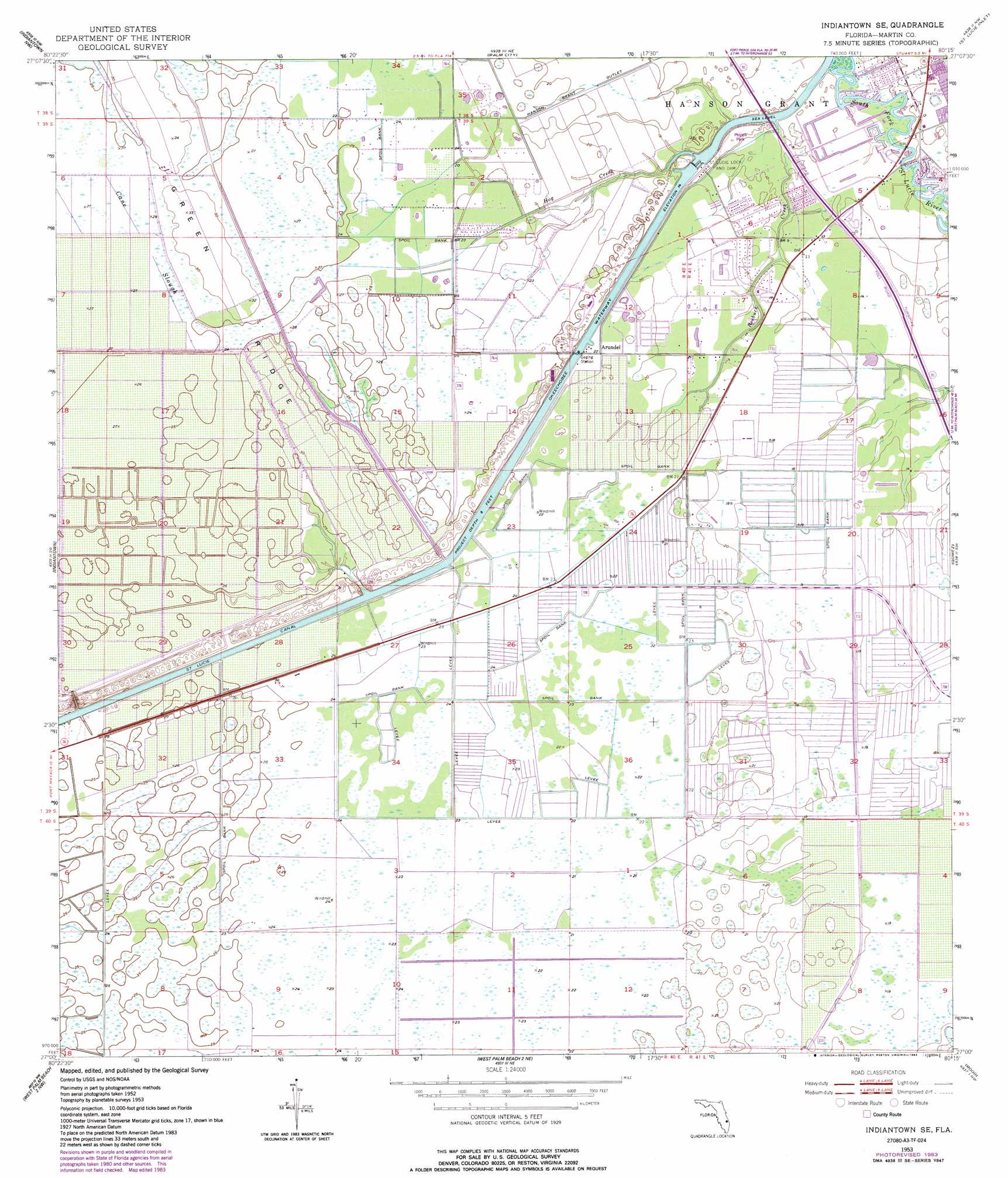
Indiantown Se Topo Map Florida
To zoom in, hover over the map of Indiantown Se
USGS Topo Quad 27080a3 - 1:24,000 scale
| Topo Map Name: | Indiantown Se |
| USGS Topo Quad ID: | 27080a3 |
| Print Size: | ca. 21 1/4" wide x 27" high |
| Southeast Coordinates: | 27° N latitude / 80.25° W longitude |
| Map Center Coordinates: | 27.0625° N latitude / 80.3125° W longitude |
| U.S. State: | FL |
| Filename: | O27080A3.jpg |
| Download Map JPG Image: | Indiantown Se topo map 1:24,000 scale |
| Map Type: | Topographic |
| Topo Series: | 7.5´ |
| Map Scale: | 1:24,000 |
| Source of Map Images: | United States Geological Survey (USGS) |
| Alternate Map Versions: |
Indian Town SE FL 1953, updated 1955 Download PDF Buy paper map Indian Town SE FL 1953, updated 1967 Download PDF Buy paper map Indian Town SE FL 1953, updated 1971 Download PDF Buy paper map Indiantown SE FL 1953, updated 1977 Download PDF Buy paper map Indiantown SE FL 1953, updated 1983 Download PDF Buy paper map Indiantown SE FL 1953, updated 1983 Download PDF Buy paper map Indiantown SE FL 2012 Download PDF Buy paper map Indiantown SE FL 2015 Download PDF Buy paper map |
1:24,000 Topo Quads surrounding Indiantown Se
Okeechobee 1 Se |
Fort Pierce Sw |
Ankona |
Eden |
|
Okeechobee 4 Ne |
Indian Town Nw |
Palm City |
Saint Lucie Inlet |
|
Okeechobee 4 Se |
Indian Town |
Indiantown Se |
Gomez |
Hobe Sound |
Port Mayaca |
West Palm Beach 2 Nw |
West Palm Beach 2 Ne |
Rood |
Jupiter |
Bryant |
Big Mound South |
West of Delta |
Delta |
Riviera Beach |
> Back to 27080a1 at 1:100,000 scale
> Back to 27080a1 at 1:250,000 scale
> Back to U.S. Topo Maps home
Indiantown Se topo map: Gazetteer
Indiantown Se: Airports
Tropical Plantation Airport elevation 8m 26′Indiantown Se: Bridges
Thomas Mauvel Bridge elevation 1m 3′Indiantown Se: Canals
Hanson Grant Outlet elevation 5m 16′Indiantown Se: Dams
Saint Lucie Lock and Dam elevation 3m 9′Indiantown Se: Populated Places
Ackel Mobile Home Estates elevation 4m 13′Arundel elevation 6m 19′
Queens Park elevation 3m 9′
Towering Pines Mobile Home Park elevation 5m 16′
Tropical Park elevation 4m 13′
Indiantown Se: Ridges
Green Ridge elevation 9m 29′Indiantown Se: Streams
Hog Creek elevation 1m 3′Roebuck Creek elevation 1m 3′
Indiantown Se digital topo map on disk
Buy this Indiantown Se topo map showing relief, roads, GPS coordinates and other geographical features, as a high-resolution digital map file on DVD: