Okeechobee Topo Map Florida
To zoom in, hover over the map of Okeechobee
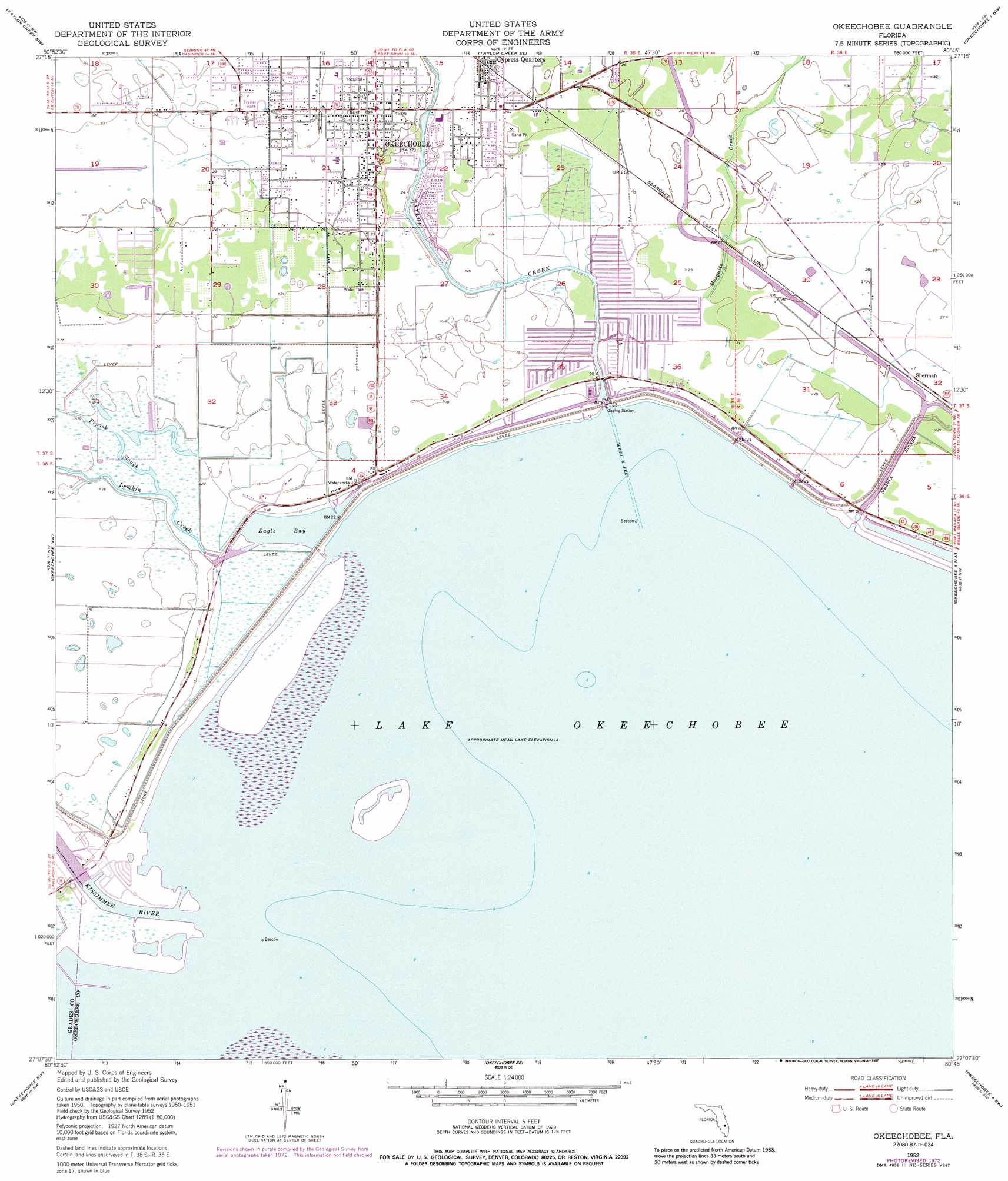
USGS Topo Quad 27080b7 - 1:24,000 scale
| Topo Map Name: | Okeechobee |
| USGS Topo Quad ID: | 27080b7 |
| Print Size: | ca. 21 1/4" wide x 27" high |
| Southeast Coordinates: | 27.125° N latitude / 80.75° W longitude |
| Map Center Coordinates: | 27.1875° N latitude / 80.8125° W longitude |
| U.S. State: | FL |
| Filename: | O27080B7.jpg |
| Download Map JPG Image: | Okeechobee topo map 1:24,000 scale |
| Map Type: | Topographic |
| Topo Series: | 7.5´ |
| Map Scale: | 1:24,000 |
| Source of Map Images: | United States Geological Survey (USGS) |
| Alternate Map Versions: |
Okeechobee FL 1952, updated 1954 Download PDF Buy paper map Okeechobee FL 1952, updated 1969 Download PDF Buy paper map Okeechobee FL 1952, updated 1973 Download PDF Buy paper map Okeechobee FL 1952, updated 1987 Download PDF Buy paper map Okeechobee FL 2012 Download PDF Buy paper map Okeechobee FL 2015 Download PDF Buy paper map |
1:24,000 Topo Quads surrounding Okeechobee
Basinger |
Taylor Creek Nw |
Taylor Creek Ne |
Okeechobee 1 Nw |
Okeechobee 1 Ne |
Fort Basinger |
Taylor Creek Sw |
Taylor Creek Se |
Okeechobee 1 Sw |
Okeechobee 1 Se |
Brighton |
Okeechobee Nw |
Okeechobee |
Okeechobee 4 Nw |
Okeechobee 4 Ne |
Brighton Se |
Okeechobee Sw |
Okeechobee Se |
Okeechobee 4 Sw |
Okeechobee 4 Se |
Fisheating Bay |
Cochrans Pass |
Port Mayaca |
> Back to 27080a1 at 1:100,000 scale
> Back to 27080a1 at 1:250,000 scale
> Back to U.S. Topo Maps home
Okeechobee topo map: Gazetteer
Okeechobee: Lakes
Eagle Bay elevation 4m 13′Okeechobee: Populated Places
Casablanca Mobile Home Park elevation 4m 13′Chapman Trailer Park elevation 5m 16′
Emily Park Mobile Home Park elevation 5m 16′
Florida Palm Mobile Park elevation 6m 19′
Four Acres Mobile Home Park elevation 5m 16′
Gator Park Mobile Home Park elevation 5m 16′
Georges Lucky Seven Mobile Home Park Number 1 elevation 5m 16′
Globe Mobile Home Park elevation 4m 13′
Hebel Acres Mobile Home Park elevation 5m 16′
J and W Trailer Park elevation 6m 19′
Jacobs Trailer Park elevation 9m 29′
Jims Place Mobile Home Park elevation 4m 13′
Johnsons Trailer Park elevation 5m 16′
Journey End Mobile Home Park elevation 4m 13′
La Fiesta Trailer Park elevation 9m 29′
Lighthouse Park Mobile Home Park elevation 5m 16′
Lone Oak Mobile Home Park elevation 5m 16′
Mayberry's Mobile Home Park elevation 5m 16′
Okeechobee elevation 8m 26′
River Bend Mobile Home Park elevation 5m 16′
S and K Mobile Home Park elevation 9m 29′
Seminole Village Mobile Home Park elevation 5m 16′
Shady Oaks Mobile Home Park elevation 4m 13′
Sherman elevation 8m 26′
Stephen's Winter Resort Mobile Home Park elevation 4m 13′
Taylor Creek elevation 5m 16′
Taylor Creek Lodge Mobile Home Park elevation 5m 16′
Town and Country Mobile Home Park elevation 4m 13′
Twin Palms Mobile Home Park elevation 5m 16′
Vantage Oaks Mobile Home Park elevation 6m 19′
Whispering Cove Mobile Home Park elevation 5m 16′
Okeechobee: Streams
Kissimmee River elevation 4m 13′Lemkin Creek elevation 4m 13′
Mosquito Creek elevation 6m 19′
Nubbin Slough elevation 4m 13′
Popash Slough elevation 5m 16′
Taylor Creek elevation 4m 13′
Okeechobee digital topo map on disk
Buy this Okeechobee topo map showing relief, roads, GPS coordinates and other geographical features, as a high-resolution digital map file on DVD: